Hello everyone, welcome to the Sunday edition of the CCN Daily Weather Update.
Your CCN Weather Update is sponsored by Freedom Insurance in Whiteville. Call 910-640-2828 or visit their office, and their experts will provide you with the peace of mind you need for whatever you need covered. From life to vehicle to homeowner, Freedom Insurance has your back.
STATISTICS FOR WHITEVILLE – Saturday February 15, 2025.
High: 69.6°F at 12:23 PM (normal is 58)
Low: 36.6°F at 6:41 AM (normal is 34)
Precip: 0.09 in
View live, real-time weather data for Whiteville on my College Street Weather Station.
Here’s your Bottom Line for today…
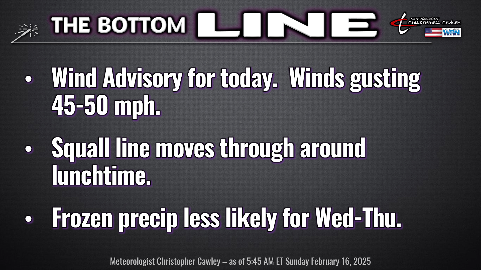
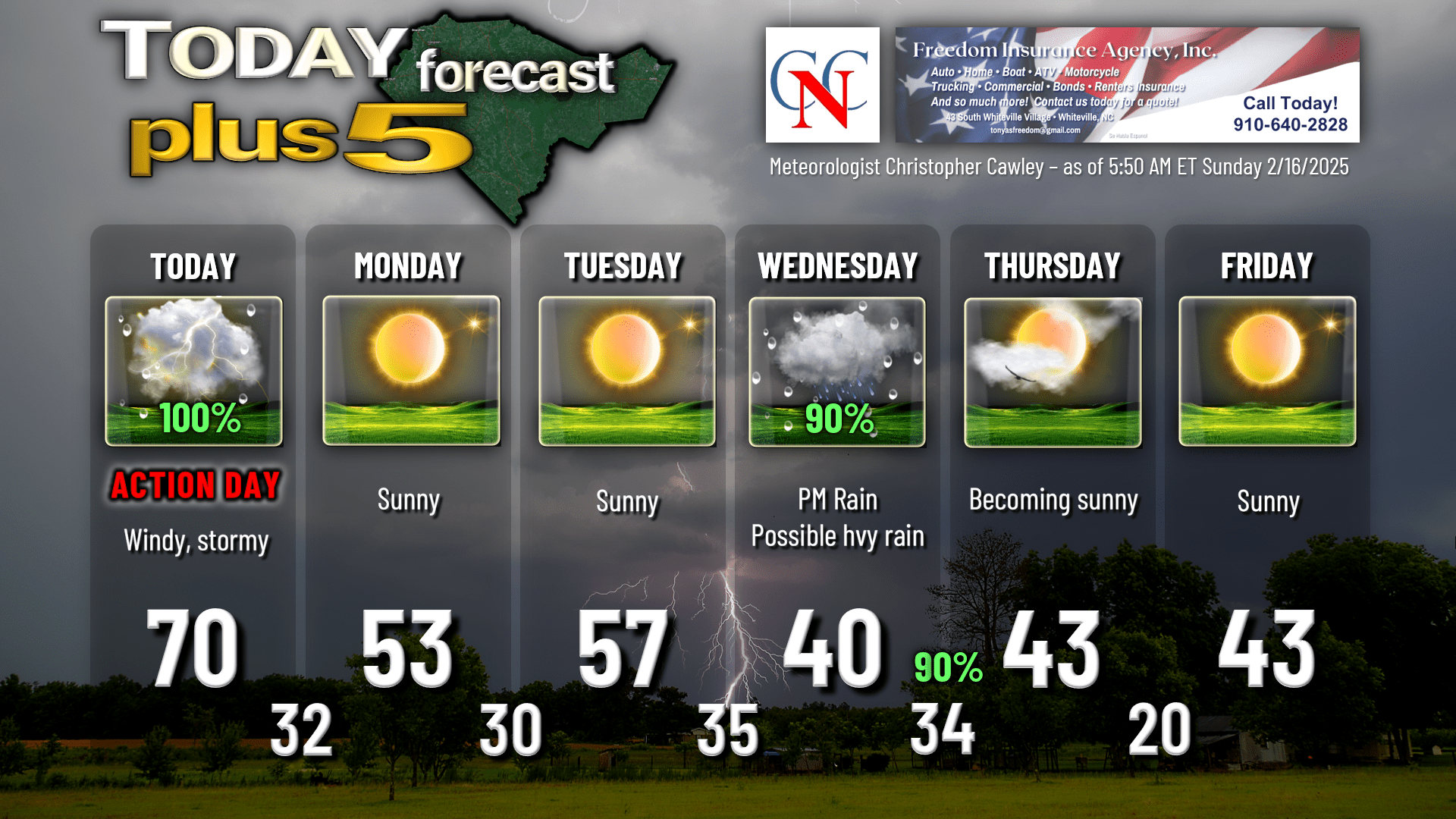
WEATHER ACTION DAY FOR TODAY.
Wind advisory is in effect until 6 PM today. Sustained winds shouldn’t be too bad, generally in the 15-25 mph range, but winds could gust 45-50 mph late this morning and then again later this afternoon.
A strong cold front will move through the area late this afternoon. Well ahead of the front, a pre-frontal squall line is likely to whisk across the state, likely moving through Columbus County between 11 AM and 1 PM.
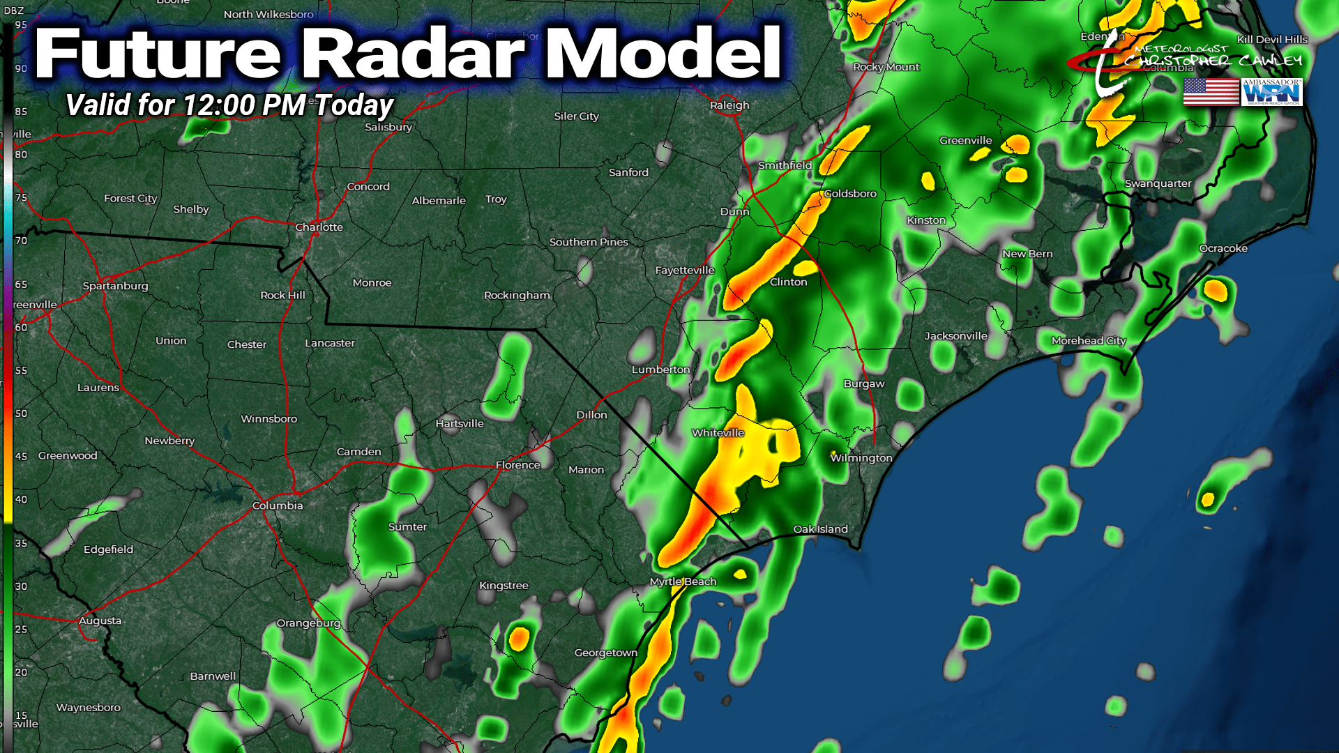
There is meager instability but a dramatic low-level jet of 70-80 mph only a couple thousand feet off the ground. The “convective showers” moving through should be somewhat low-topped; however, any updrafts pushing into that low-level jet could result in the isolated damaging wind gusts here at the surface.
I think the convective line will be largely bereft of lightning. There may be one or two rumbles of thunder but on the whole, these won’t be “thunderstorms” like we would see in the summertime.
The line moves through fairly quickly, dropping a burst of intense rainfall, and then that’s it. The whole “event” lasts about an hour, beginning to end. We should be mainly dry after the squall line moves through… perhaps an isolated light rain shower during the afternoon. Some breaks of sunshine are likely as dry air pushes in with the cold front, but another crescendo of gusty winds is possible with the actual frontal passage.
We’re crystal clear and SHARPLY COLDER tonight. We will remain somewhat breezy overnight as our lows drop to around the freezing mark.
Dry weather will be the rule Monday and Tuesday. Monday will be a touch on the cool side with highs around 50, but on Tuesday our highs should be around seasonable normal, in the upper 50s. Lows Monday night drop back to around 30… possibly some upper 20s in the outlying areas.
SIGNIFICANT STORM TO IMPACT OUR AREA WEDNESDAY AFTERNOON AND WEDNESDAY NIGHT.
It is looking more and more like this is going to be a bone-cutting-cold rain through the entire event… but that still isn’t quite gospel yet.
Low pressure is likely to organize on the southern branch of the jet stream sometime Tuesday. This low moves off the Georgia coast and rapidly strengthens. The low is then likely to lift northeast along the coast.
Meanwhile a northern-stream “shortwave” (disturbance) dives south into the Ohio Valley, and then crosses the mid-Atlantic and moves off the coast. This will bring colder air down into the Carolinas.
The exact track of the low and the magnitude of the cold air will determine precipitation types. All three deterministic models keep the low close enough to the coast that we’re all rain Wednesday afternoon, although the European model has ice precariously close to our area — north of a line from Dillon through Tar Heel through Clinton. The GFS has the ice much farther to the north.
These deterministic plots are still going to change a multitude of times between now and the actual event.
If you have travel plans into central and northern NC Wednesday and Wednesday night, prepare for a significant winter storm producing icing across central NC, and snow/ice for northern NC. As of this writing (5:50 AM Sunday), it looks like it’s juuuuust going to miss us here.
The way I see things as of this morning, we’ll have COLD rain developing Wednesday afternoon, with moderate to heavy rain possible late Wednesday into Wednesday night. Our highs occur early on Wednesday; as the rain moves in, temps fall into the middle and upper 30s in the afternoon. Rain continues Wednesday night… heavy at times during the evening…. then tapering off after midnight. As the storm pulls away, wrap-around cold air will funnel in and we could end as a little bit of wet snow during the pre-dawn hours Thursday, but the ground will be too warm and far too wet for any of the potential snow to actually stick.
I’m going with a 90% probability of precipitation Wednesday afternoon and Wednesday night. It’s a near-certainty. Again, I believe we’ll be mostly rain… but “stay tuned.”
There’s still a chance that the low actually rides inland from the coast, up the I-95 corridor, and if that turns out to be the case, we’re in a warm sector and we’re in a “shower-and-thunderstorm” regime. There’s about a 1% chance that actually happens, thanks to that northern-stream disturbance I mentioned above. Laws of Physics and all that good stuff.
After the storm system leaves the area, a true-blue Arctic air mass will linger over the area into next weekend with unseasonably cold temps. Lows Thursday night and Friday night might drop into the teens. A quick glance at the deterministic plots shows what could be an extended period of dry weather, possibly through the end of the month. Warming trend possible beginning around the 24th.
Here’s your Freedom Insurance Today-Plus-5 forecast for Columbus County.
That’ll do it for today. Thanks for reading, and as always, take care!
~Meteorologist Christopher Cawley