Hello friends, welcome to the Tuesday edition of the CCN Daily Weather Update! Our update is brought to you exclusively by Freedom Insurance of Whiteville. The outstanding representatives at Freedom will always go above and beyond to help get you the best coverage at the best rate possible. This is for all policies, both business and personal. Customer service is taken very seriously at Freedom. Contact them today at 910-640-2828.
STATISTICS FOR WHITEVILLE – Monday February 3, 2025.
High: 69.5°F at 3:11 PM
Low: 43.2°F at 7:11 AM
Precip: 0.00 in
View live, real-time weather data for Whiteville on my College Street Weather Station.
Here’s your Bottom Line for today…
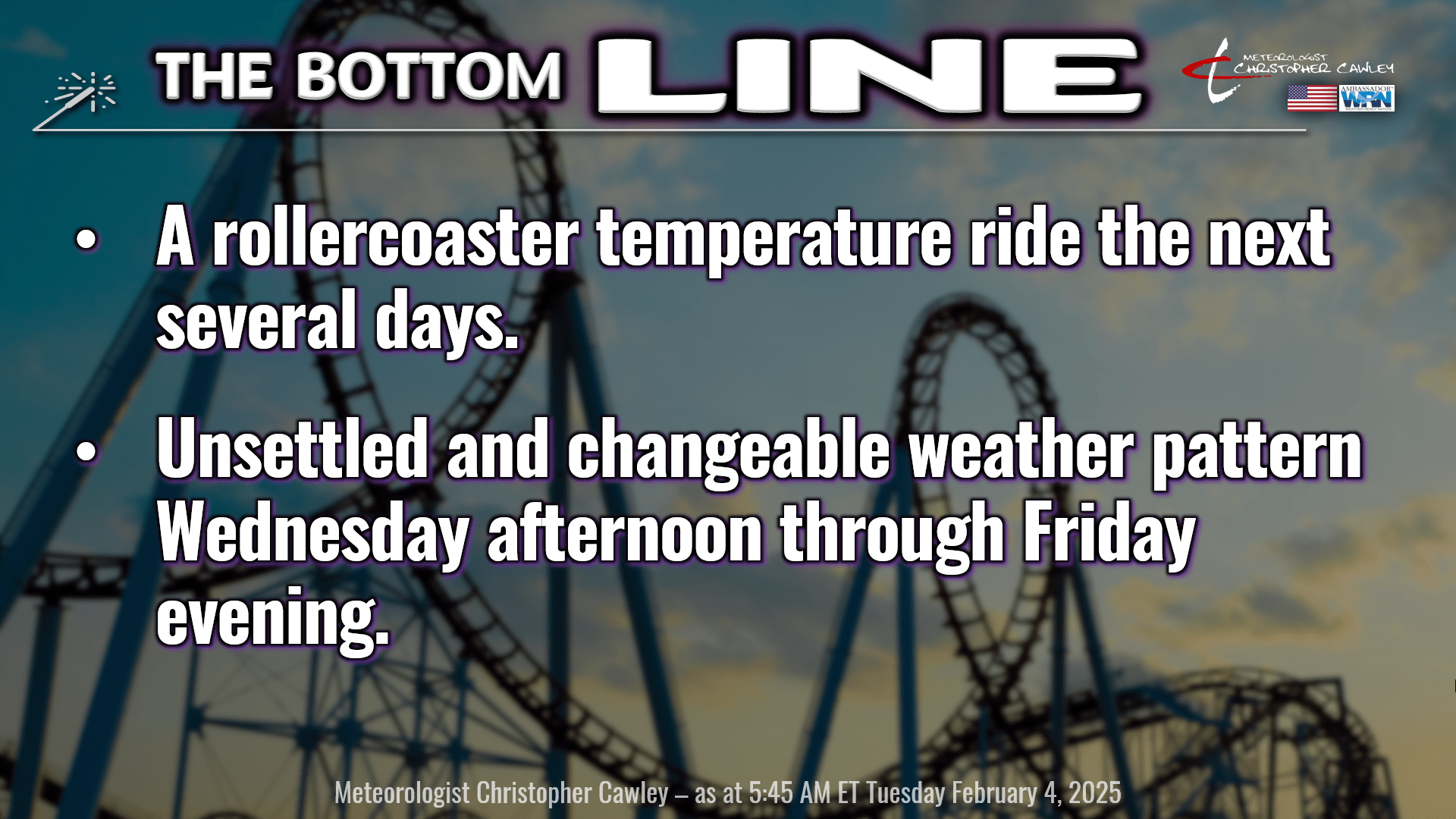
Ok friends, let’s just dive right into things. We are going to enjoy a warm and mostly sunny day today. BUT… a cold front will drop south through the day. We’ll notice a few clouds in the afternoon and a wind shift from the southwest to the north. The latest short-term guidance suggests this wind shift/frontal passage occurs sometime between roughly noon and 4 PM.
Then things get murky… and honestly my forecast confidence is only about 50/50.
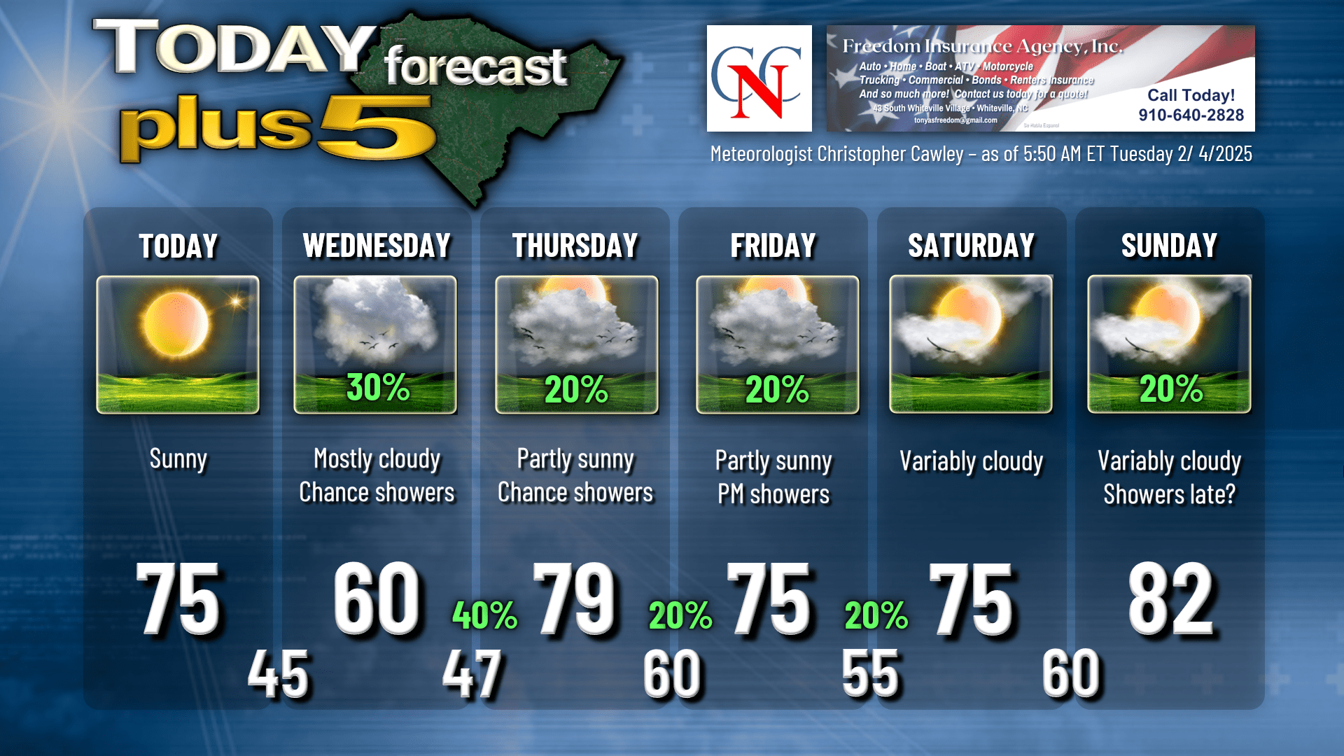
The roller coaster drives DOWN on Wednesday. High pressure over Michigan, combined with the frontal boundary draped from roughly Atlanta through Savannah, will result in a nearly due-east wind flow directly off the cold Atlantic ocean. I expect a good bit of cloudiness throughout the day Wednesday, along with some spotty light rain showers in the afternoon. I put a “60” on the chart for Wednesday, but that might be a bit of a stretch. We’ll probably be more in the mid and upper 50s, which is actually where we SHOULD be this time of year.
Things then get fairly complicated and unsettled through the rest of the work week. A large, sprawling storm system is expected to lift into western Arkansas by Wednesday evening. This will bring a series of frontal boundaries, warm and cold, to the area through Friday evening. A warm front will lift quickly northward over the Carolinas and into the northern mid-Atlantic by Thursday morning. We will probably see a few showers Wednesday night with this frontal passage, along with rising temps during the overnight.
For Thursday we’re solidly in a warm sector, with a deep, moist southwesterly flow becoming established over the County. So we’re UPWARD on that roller coaster once again, and highs flirt with 80.
A cold front crosses the area sometime Friday afternoon; the best “forcing” heads north of us, but I believe a few scattered showers are in the cards for Friday afternoon. There could be some thunder chances Friday afternoon depending on how fast this front moves through… but I doubt it. I put our precip chances at 20% on Friday.
Temperatures on Friday will depend on the “where and when” with that frontal boundary. South/east of the front, temps will be higher than areas north/west of the front. So my forecast high for Friday has a limited level of confidence.
The front is expected to linger just to our south on Friday night before moving back north as a warm front early on Saturday. This will keep clouds and light shower chances around, with lows
staying mild on Friday night and temperatures continuing well above normal on Saturday.
It LOOKS like we have fairly decent rain chances, but the National Blend of Models rainfall chart shows a grand total of a quarter of an inch of rainfall Wednesday afternoon through Friday night. Yeah. That’s … hardly anything.

A lull in the action occurs Saturday night through most of Sunday as we await yet another cold front.
THE cold front.
Ahead of the front on Sunday, our temperatures jump into the lower 80s on a big-time southerly push of humid air. Depending on the timing of the front, thunderstorms could occur later Sunday afternoon. I’m not at all confident on the timing of all this, so for Sunday I put a “20%” on the chart.
The cold front comes crashing through late Sunday or Sunday night. This front will mean serious business and will usher in a complete pattern change for the area. Our “false spring number one” will come to a very abrupt end Sunday night as our temperatures turn colder … actually returning to seasonal normal values by next week.
Before I get into the “long term” discussion, here’s your Freedom Insurance Today-Plus-5 forecast for Columbus County.
LOOKING AHEAD: Ok folks, this is long. If you’re the “TL;DR” crowd, here is the Cliffnotes version for the period February 10-15. 1) Colder temps. 2) Active weather pattern with potential for rain… ice… and/or snow. 3) Too early to make any real call.
Next week looks interesting, and I’m only addressing this because of some things I saw on the social media on Monday afternoon.
In almost a repeat of what happened in January, a “bubble” of the polar vortex is expected to drop south over Canada and impact a good portion of the United States. The difference is that it’s not likely to be anywhere nearly as cold or long-lasting as what we had.
In almost a repeat of what happened in January, an active weather pattern is fairly likely to occur at the base (the southern end) of this trough, this “bubble.”
Do you smell what The Rock is cooking?
Deterministic models are all over the place next week… and at one point showed a significant ice event for most of NC. This is what was shared on the interwebs on Monday. Flip-flop and now the latest deterministic guidance no longer shows that, going with a fairly heavy rain event.
Folks, I cannot stress this enough. The “single image model pics” that you see on social media are just that. A single snapshot from one model at one moment in time. If someone is sharing something that is set to occur a WEEK from now, ignore it. Beyond day #5, I almost completely discount deterministic model charts.
But I DO look at ensembles. They are excellent for longer-range forecasting because they “smooth out” extremes to give a more balanced picture of what could occur. There’s still only a 50/50 shot of verification at day 7-10+, but they’re good for a sense of what could come.
So, what do the ensembles show for next week? There are 82 total ensemble “members” of the big two, the Euro and GFS. Out of 82, 10 of those show accumulated snowfall for Whiteville during that timeframe. Out of those 10, only 2 — TWO — have accumulations greater than 1 inch.
However, ALL of the 82 show precipitation (likely rain) occurring during the same time period. The members range from a few tenths of an inch to over 6 inches of RAIN between the 11th and 15th. The “averages” are coming in between 1 and 3 inches of rain next week, and if that comes to fruition, that will go a long way to putting a dent in the drought.
Anyway… my previous experience and logic indicates that an area of low pressure forms on the southern edge of the “bubble” of cold air expected to be over the east. Where it goes I can only hazard a guess this far out in time. However, if it rounds the base of the trough, it stands to reason that a significant precipitation system COULD occur NEXT week. Whether that be rain, ice, or snow is a gigantic unknown at this point. There’s absolutely no way to make that determination at this point.
The point is… winter is on break this week, but will likely return to ColCo next week and potentially beyond.
That was long, and I realize that, but I wanted to at least “set the stage” on what could happen next week. If you see the sexy, scary graphics on social media, keep scrolling.
Oh, and those weather apps? Like I (and others) said last month, after “today-tonight-tomorrow,” the data they show is worthless.
That brings an end to today’s report. Thank you for reading and for supporting ColumbusCountyNews.com I hope you have a fantastic day, and as always, take care.
~Meteorologist Christopher Cawley