Greetings folks, and welcome to your CCN Daily Weather Update for Saturday March 29, 2025.
This weather update is sponsored by Freedom Insurance of Whiteville. Protect what matters with Freedom Insurance. Life is full of surprises, but with Freedom Insurance, you’ll always be prepared. Whether it’s your home, car, business, or health, we provide customized coverage to keep you and your loved ones secure. Contact Freedom today at 910-640-2828!
STATISTICS FOR WHITEVILLE – Friday March 28, 2025.
High: 80.3°F at 2:21 PM (normal is 69)
Low: 46.6°F at 4:29 AM (normal is 44)
Precip: 0.00 in
View live, real-time weather data for Whiteville on my College Street Weather Station.
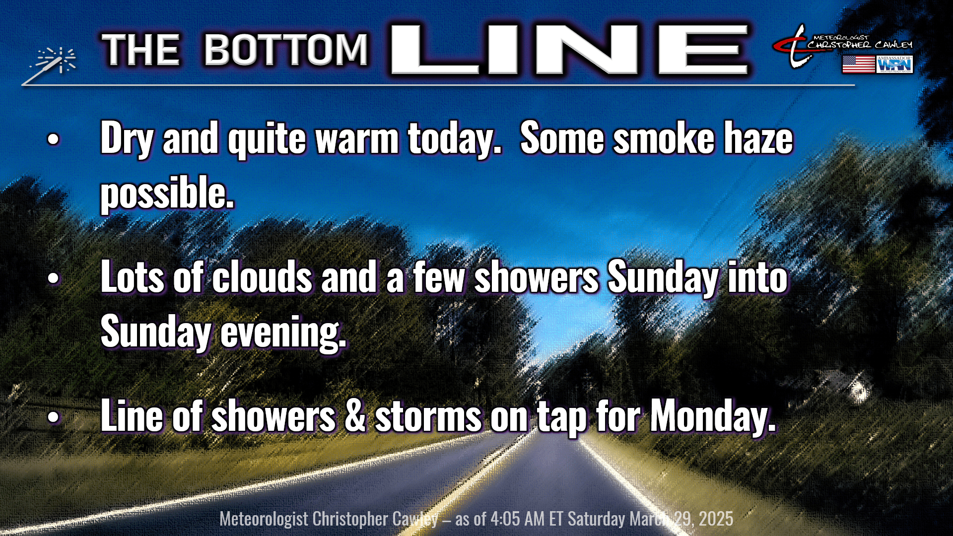
Here’s today’s Bottom Line
High pressure offshore will influence our weather for one more day today before an upper-level disturbance takes aim for Sunday.
Warm and increasingly humid across the area for today as a southerly flow really takes hold. There may be some haze this afternoon from some of the smoky remains of area fires. I don’t think it’ll be anything too impressive, but I did want to make mention of it.
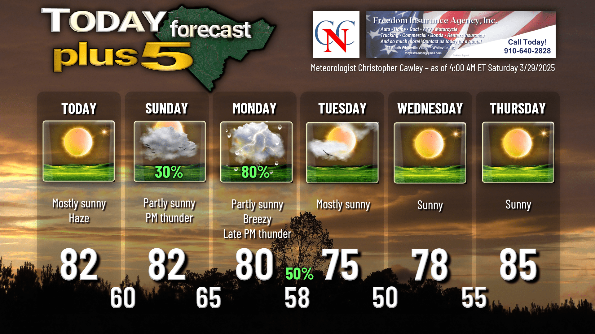
Temps today will be right around 80, or possibly into the lower 80s. But if you’re planning on traveling to our area beaches, it will be MUCH colder with highs struggling to top 70 thanks to the onshore flow from a cold, cold ocean.
An impressive low pressure center will rocket northeastward through the Ohio Valley into northern New England between Sunday and Monday. This will help push the surface high farther out to sea… and increases some RAIN chances (YES!). A few scattered showers are possible Sunday into Sunday night in the deep, moist southerly flow. Nothing significant, nothing to get too excited about, but some rain!
Then the main focus will be our weather action day on Monday. The guidance shows me there will be plenty of instability and a decent amount of shear. The source of lift is our front. What concerns me is that there could be a timing mishap between the arrival of the “best” instability and the “best” shear, and we’re left with nothing but a line of showers moving through. All of the modeling tells me that the best shear doesn’t arrive until the evening hours, while the instability peaks during the late afternoon.
A line of convection will be moving eastward across the state on Monday. What kind of shape it’s in by the time it reaches our area remains to be seen. As for timing, I’m targeting late afternoon through the evening hours, and on our graphic I put 80% for Monday (mainly after 3 PM) and 50% for the evening (mainly before 9 PM)… but this may get adjusted when I look at tomorrow’s modeling.
After that, high pressure ridges back into the area for the middle and later half of next week… with temps possibly flirting with 90 by the end of the week.
Here’s your Freedom Insurance Today-plus-Five forecast:
That will conclude today’s report. Thanks for reading, and as always, take care.
~Meteorologist Christopher Cawley