CCN Weather Update for Wednesday June 25, 2025.
This weather update is sponsored by Freedom Insurance of Whiteville. When severe weather strikes, with Freedom Insurance you will always be prepared. For home, car, boat, or whatever you need, Freedom can provide customized coverage to keep you and your family safe. Contact Freedom today at 910-640-2828!
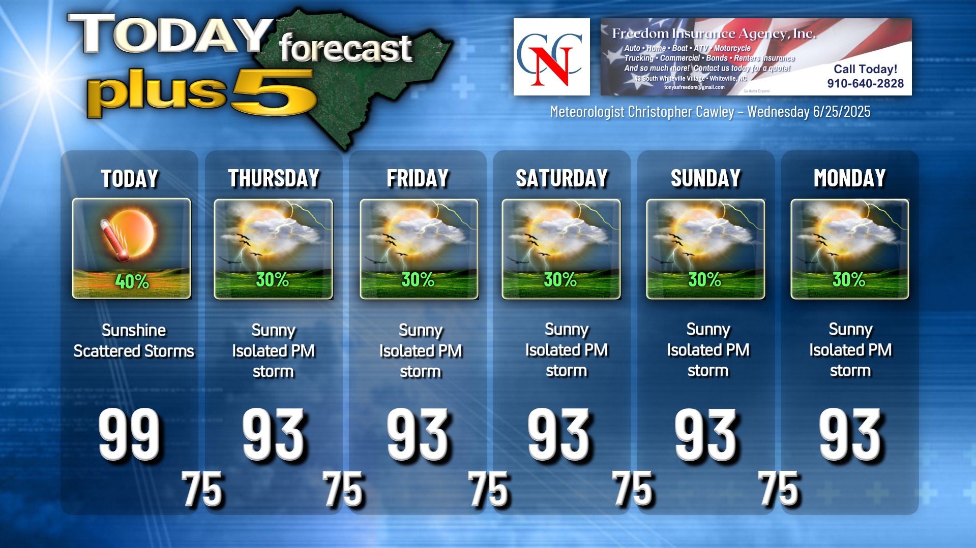
High temperature at College Street in Whiteville on Wednesday was 101.0°F. The high temperature forecast was 101°F. The highest heat index was 114.2°F.
Here’s today’s Bottom Line
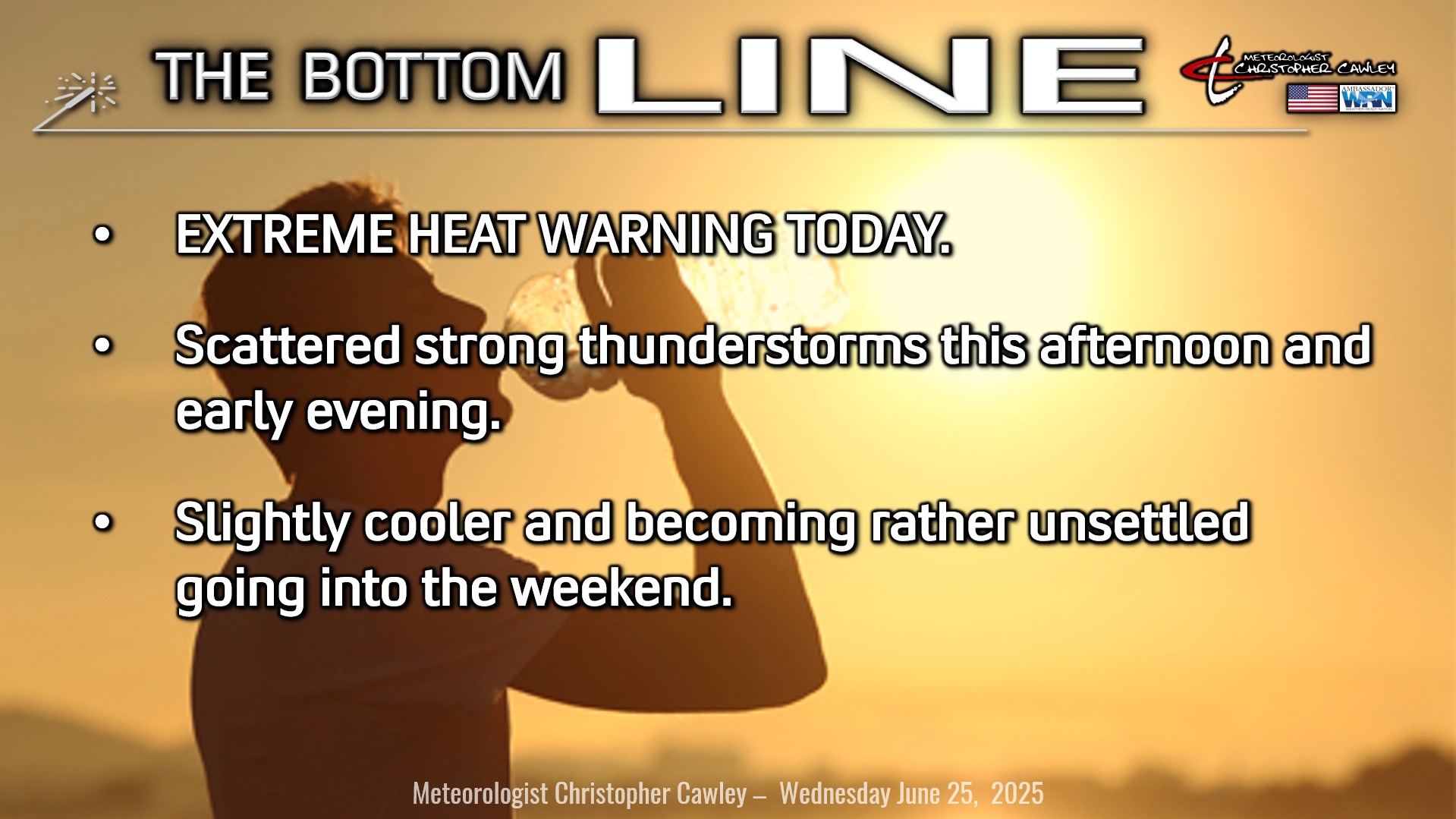
EXTREME HEAT WARNING for today. High temps might not crack the Misery Mark today (I’m going with “99” on the graphic), but it is certainly possible. There will be a coverage of showers and thunderstorms later this afternoon, and locations that receive a storm will not break the 100-degree mark.
HOWEVER, heat index values will still be in the very dangerous category as humidity will be higher today, with the storms around the area.
As mentioned yesterday, outdoor activities between 11 AM and 7 PM should be avoided if all possible. If you must be outdoors, please take frequent breaks, drink plenty of water or Gatorade, and wear loose-fitting, lightweight clothing.
The high-pressure dome/ridge is starting to break down today and shifting just a smidge to the north/east. This will allow a weak upper-level area of low pressure to drift westward into Florida, and then slowly wobble its way northward into the southeast US through the weekend.
As mentioned, scattered showers and thunderstorms are expected this afternoon. Instability numbers (including downdraft-CAPE, surface-based CAPE, and mixed-layer CAPE) are … honestly quite eye-popping. However, the shear just isn’t going to be supportive of organized storms, and there is a fair abundance of dry air high in the atmosphere. That being said, today looks picture-perfect for cold-pool formation, meaning the stage is set for wet microbursts. These could produce locally damaging wind gusts. As such, the NWS Storm Prediction Center has our county under a level 2/5 risk today. Keep an eye/ear to the sky.
A word about lightning: Yesterday, some of you might have heard that near Columbia, SC, a number of individuals were struck by lightning while outdoors. If you can hear thunder, you’re close enough to be struck by lightning.
Any and all storms that form will be prolific lightning-producers this afternoon. They will also produce a period of blinding rainfall.
As mentioned, the upper low kind of wobbles over the area through the weekend. On the whole this means we’ll experience partly to mostly sunny skies each day with the chance for afternoon and evening thunderstorms in a markedly unstable environment. While we won’t have advisories or warnings, and actual highs will be — right where they should be this time of year — heat index values will range in the 100°F to 105°F area each day. Overnight lows generally in the mid 70s through the period.
TROPICAL OUTLOOK: ICYMI, tropical storm Andrea formed in the central Atlantic, as the system I’ve spoken about the past few days defied logic and expectations (and cold surface waters), and strengthened into a weak tropical storm. The system, as of this morning, is dying and I don’t expect it to survive … probably by the time you read this, Andrea will be a memory. Otherwise, no tropical activity is expected.
Here is your Freedom Insurance Today-plus-Five Forecast:
–Meteorologist Christopher Cawley