CCN Weather Update for Saturday November 29, 2025.
This weather update is sponsored by Freedom Insurance of Whiteville. You can trust Freedom Insurance to give you clear blue skies when it comes to home, car, boat, or whatever insurance you need. Let Freedom provide customized coverage to keep you and your family safe. Contact Freedom today at 910-640-2828!
Here’s Today’s Bottom Line!
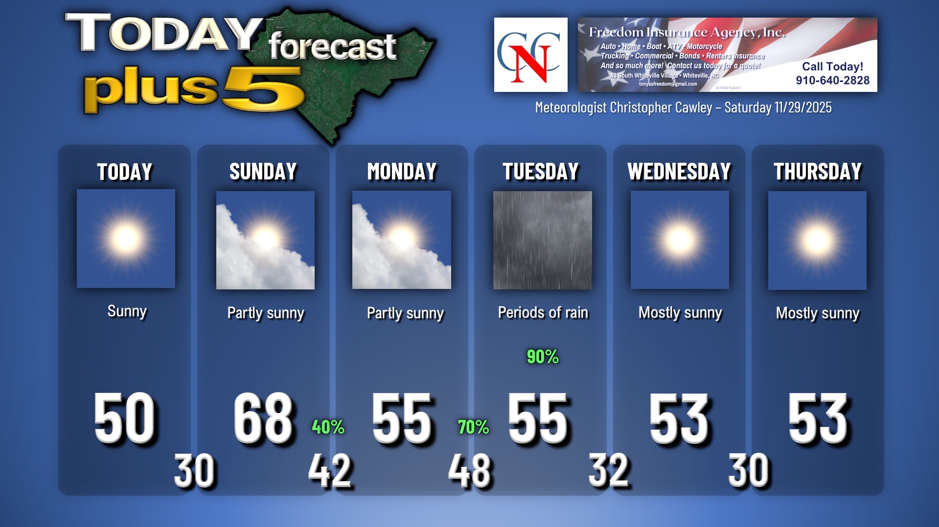
Dry weather and chilly temps will continue today. After the brutal start we’ll have highs maybe pushing 50 degrees. It won’t be as cold tonight as high pressure starts to slip off the coast. Clear skies continue with lows around 30.
On Sunday, a coastal boundary pushes inland ushering in dramatically warmer temperatures with a mix of sunshine and clouds. Highs will reach the upper 60s on southerly winds by Sunday afternoon.
Don’t get too used to it. A cold front crosses the area Sunday night, and with this comes an increase in moisture and the potential for some scattered showers. This isn’t going to be all that significant, but at least some rainfall comes Sunday night.
The front then stalls offshore on Monday. We should have a quiet… but chilly… day as far as our “sensible weather” goes. A mix of sunshine and clouds with highs in the 50s.
Then all eyes turn on the system that will impact our area Monday night and Tuesday. This will bring the best rain chances we’ve seen in a long time. A wave of low pressure will come together in the Gulf and quickly push through the Carolinas through Tuesday. The latest modeling suggests a coastal track, but there is still considerable disagreement in these models. An even bigger forecast problem right now is the speed of the low, where model data is spread out all over the place. So these details will play huge roles in determining our temperatures, rainfall amounts, potential instability for thunderstorms, and more.
Right now the model blends paint a good solid inch to 1.5 inches of rain across much of the area Monday night and Tuesday. Given the very dry overall conditions, I don’t believe there will be any concerns with flooding “overall,” but some minor poor-drainage ponding may occur on Tuesday depending on how heavy the rain falls.
Tuesday’s rain is a near-certainty, I’m going with 90% on the forecast graphic.
Colder air wraps in behind the departing system Tuesday night. There may be enough leftover precipitation in the area that we see a brief mix with some wet snowflakes late Tuesday evening before everything ends by midnight. Don’t get too excited though.
Cool high pressure then builds in and clears us out for Wednesday and Thursday. Temps are likely to run below normal through the end of the week.
Here’s your Freedom Insurance Today-plus-5 Forecast:
–Meteorologist Christopher Cawley


