CCN Weather Update for Friday January 9, 2026.
This weather update is sponsored by Freedom Insurance of Whiteville. You can trust Freedom Insurance to give you clear blue skies when it comes to home, car, boat, or whatever insurance you need. Let Freedom provide customized coverage to keep you and your family safe. Contact Freedom today at 910-640-2828!
Here’s today’s Bottom Line:
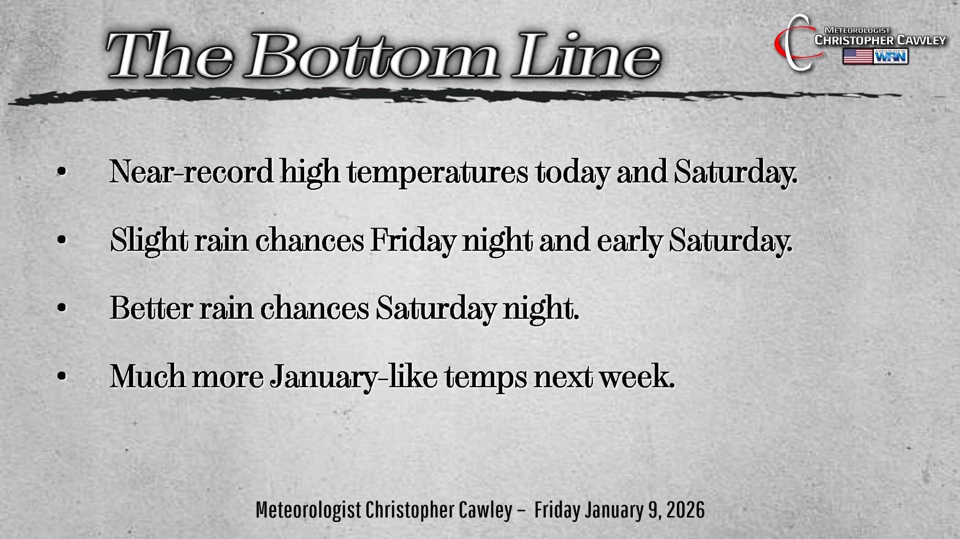
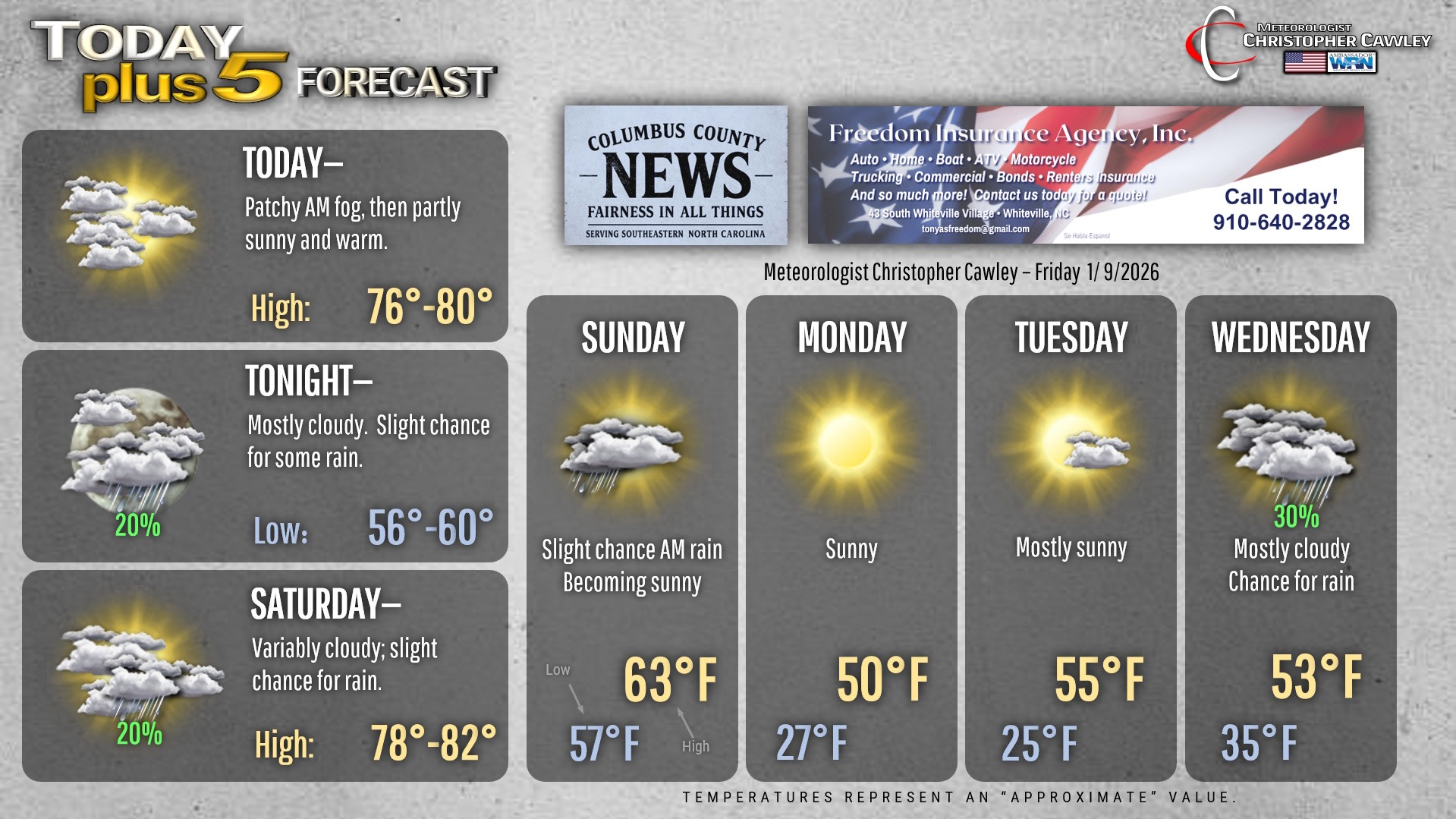
A warm front has moved north of the area early this morning. We have some patchy fog around, but that won’t stick around too long and we’ll be left with a mix of sunshine and clouds for today. Our temps will jump quite a bit today, cresting in the upper 70s.
We’ll see a good bit of cloudiness tonight in the moist air mass, some fog is also probable once again. Lows will be higher than our normal highs… probably not dropping much below 60.
Saturday will feature more near-record-warmth and breezy conditions. A very moist air mass in place may allow for the development of some patchy light rain in the morning hours. but we’ll see increasing sunshine through the afternoon and highs right around 80.
King-sized cold front then blows through the area Saturday night. Fairly good chances for rain along and ahead of the front, but overall rainfall totals will be less than a tenth of an inch… so nothing that will be drought-busting by any means. Breezy conditions will continue as well.
A secondary front drops through early Sunday, and this may bring a rain shower or two, but again we become sunny by the afternoon. Big different in temps, though, as we’ll struggle to the lower and middle 60s (still 10 degrees above normal)…. but those highs should occur in the morning hours. I expect temperatures to slowly fall during the afternoon as cold air starts to push in from the northwest.
Temps then take a nosedive Sunday night with clear skies, and we’ll be in the upper 20s to around 30 first thing Monday morning. Full sunshine on Monday won’t help our temps much on the strength of the cold air… highs will be around 50.
Another cold night Monday night as we drop to the mid and upper 20s. Temps on Tuesday will be right on target for mid-January, generally in the mid 50s.
Our next frontal system approaches by the middle of next week with some rain chances on Wednesday.
MODEL PANIC. A colleague of mine, a much-respected local meteorologist, posted on Thursday some very good comments that I’d like to summarize here.
As more typical January weather settles in, we’ll see what will probably become a more active weather pattern. Models have a notoriously difficult time handling various weather systems, especially once we’re more than 5-7 days out. These weather patterns often produce what he called “fantasy” storms on the models, and like hurricane season, they’ll get shared far and wide on social media. You’ll hear scary terminology like “bomb cyclone” and “historic” snow and… worst of all… “polar vortex.” You’ll even see/hear these on television media outlets.
Despite what the social mediaologists are saying, there’s nothing interesting on the horizon. Just seasonably cold temperatures with possible chilly rain systems through the end of the month. And hey, we need the rain, but yeah, “rain and 45” isn’t nearly as clickable as “historic snow.” Please don’t fall for the hype. I don’t play the hype game. If there’s a storm coming, you’ll read about it here or on my own social media pages… without the hype.
Here is your Freedom Insurance Today-plus-Five Forecast:
–Meteorologist Christopher Cawley