
CCN Weather Update for Saturday January 24, 2026.
This weather update is sponsored by Freedom Insurance of Whiteville. You can trust Freedom Insurance to give you clear blue skies when it comes to home, car, boat, or whatever insurance you need. Let Freedom provide customized coverage to keep you and your family safe. Contact Freedom today at 910-640-2828!
Here’s today’s Bottom Line:
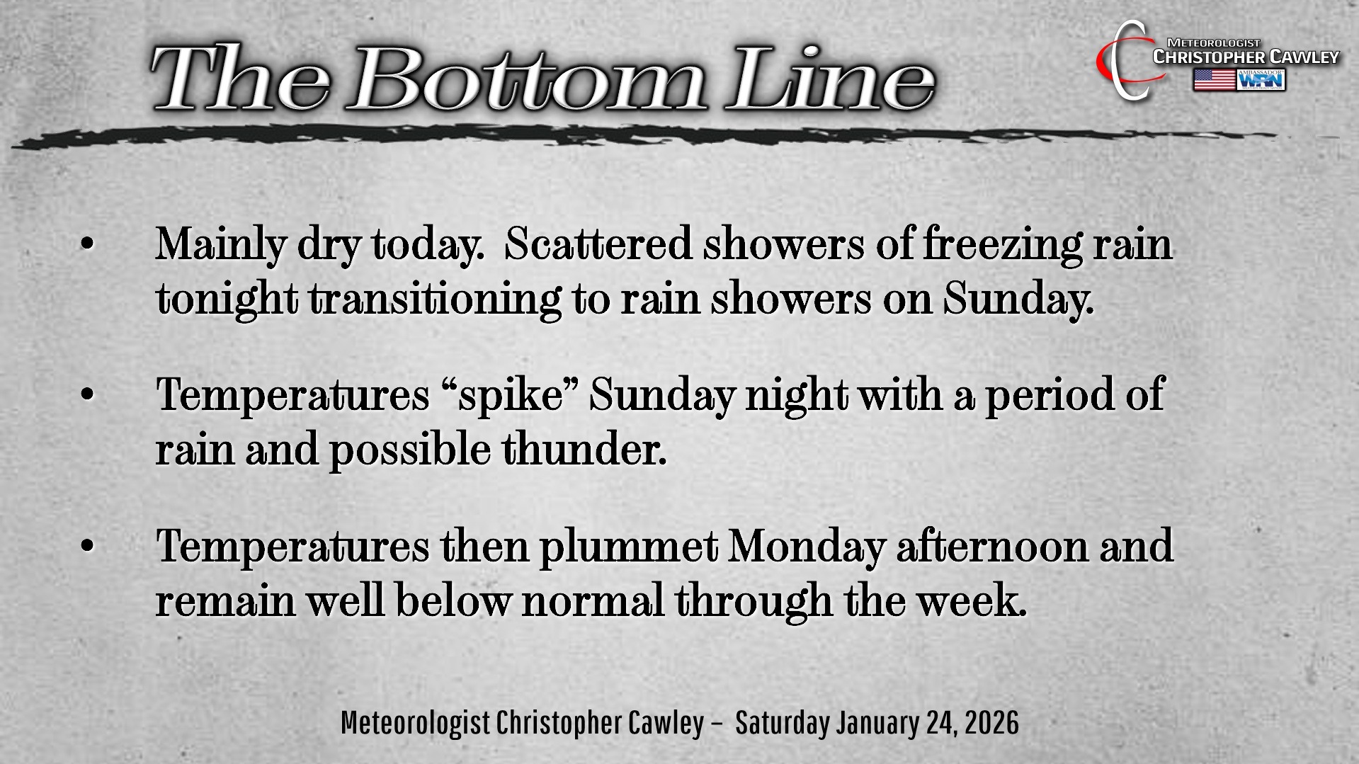
Winter… to a taste of spring for a minute… back to a deep freeze… all in 48 to 60 hours!
This is a wacky, crazy, strange, unusual, almost nonsensical forecast, especially with the temperature swing we’re going to take late Sunday through Sunday night into Monday.
This storm system is going to make what little hair I have turn white.
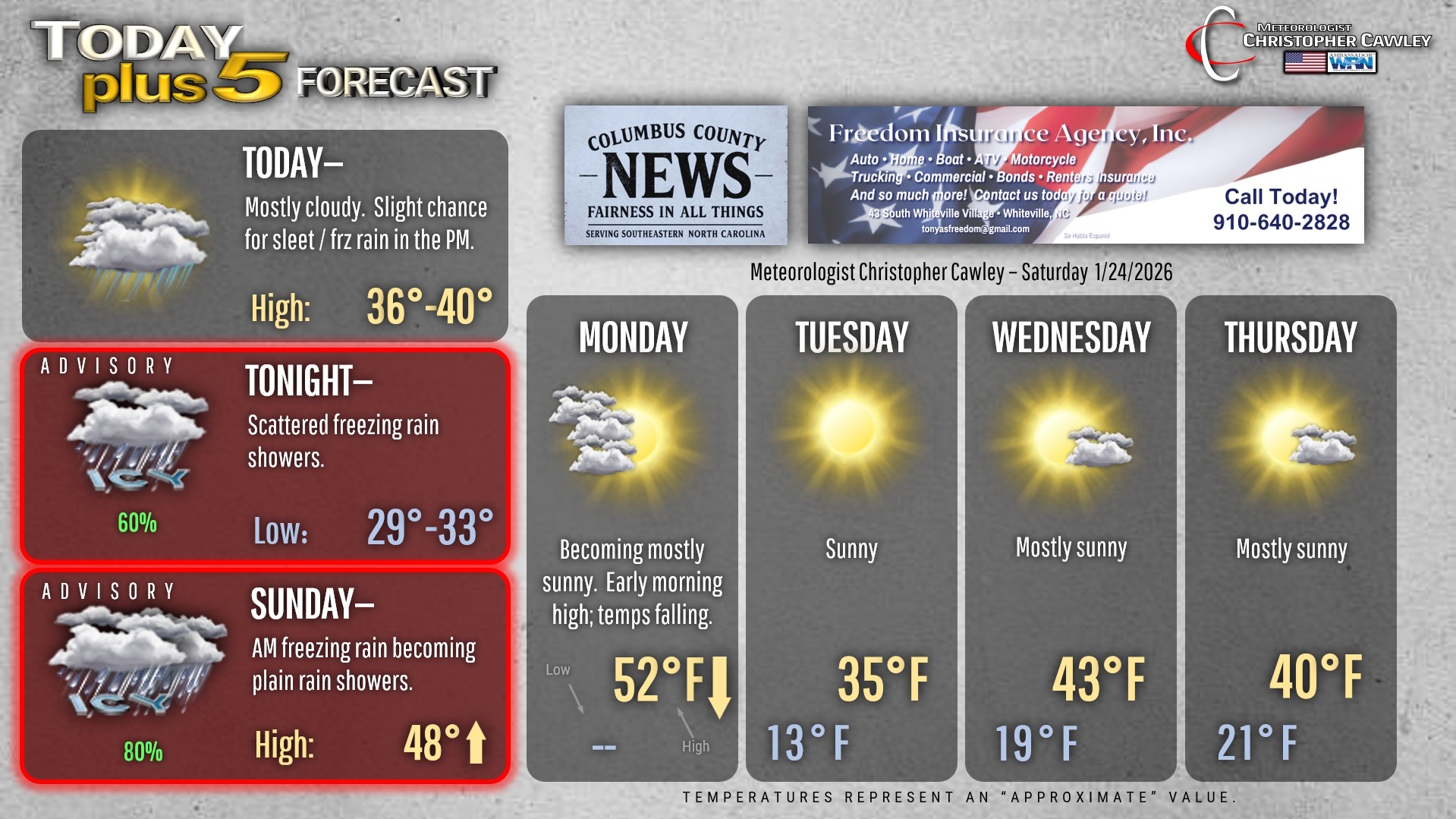
TODAY: Quiet weather most of the day. Precipitation starts to develop around or after suppertime in the form of light sleet.
Shallow and VERY DRY Arctic air at the surface will be “overrun” by moisture pushing in from the southwest. This moisture will be accompanied by mild air (originating from the Pacific and western Gulf). Atmospheric profiles suggest sleet will be the predominant precipitation type for anything that develops Saturday evening. The surface air will be so dry that some of the moisture will evaporate before reaching the surface.
SATURDAY NIGHT: An increasingly warm and saturated southerly flow just above the surface reduces the Arctic surface air mass to only about 1000-2000 feet in thickness (essentially from the ground to 1000-2000 feet). The rest of the atmospheric profile to the cloud level will be above to well-above freezing. So it will be “raining,” except the rain will glaze anything it lands on at the surface — hence freezing rain. Based on the short-term modeling, it should be showers of freezing rain… I don’t think (at this point) it will be a solid shield east of I-95. I’m not ready to jump on a completely dry solution either, so we’re going with freezing rain showers Saturday night. There’s a chance that we wake up Sunday morning to a completely dry ground.
SUNDAY: Here’s where things get wonky as we go from (potential) ice to (potential) thunder. Yep.
Short-run modeling shows the warmer air mass advancing inland through the morning, reaching the I-95 corridor by noon. Any showers of freezing rain will transition to rain showers through the morning hours over Columbus County. Low pressure center #1 then passes just offshore.
Temperatures continue to climb for all areas east of 95 through the afternoon into the evening. So on the graphic, I put “48” with an up-arrow. The highs will take place late in the evening… probably closer to midnight.
SUNDAY NIGHT: Low pressure #2 forms and takes an inland track over the Carolinas. This brings in much warmer air off the Atlantic and a slug of rain…possibly heavy rain… and maybe some thunder. Temperatures RISE Sunday night, peaking in the upper 40s to lower 50s, followed by a steady and precipitous fall on Monday.
It’s hard to illustrate on the graphic how this temperature curve is going to play out… so there’s no “low” listed for Sunday night/early Monday. Monday’s high temperature will likely occur during the pre-dawn hours … by the time everyone heads home from work Monday evening we’ll be tumbling through the lower 30s.
Full transparency: This is an absurdly low-confidence forecast. Some modeling suggests temps reach the 60s during the overnight! In simpler/happier times I would say, “no that ain’t happening,” but with this storm system… nothing would surprise me.
So, the cliffnotes version: Rain Sunday night, temps rising during the night into the lower 50s, then rapidly falling back to reality on Monday with clearing skies. Maybe.
Monday night turns downright frigid as temps keep going down-down-down on gusty west/northwest winds. Lows early Tuesday fall to between 10 and 15 degrees (!!) with wind chills in the single digits. The NWS will likely issue cold weather advisories.
Colder-than-normal temps continue through much of the week with mainly dry weather.
There may be something interesting to watch by next weekend but it’s beyond “too soon” to even give that much consideration right now. Temps do remain well below normal through the end of the next work week so any areas of low pressure on the southern jet will need to be watched.
Here’s your Freedom Insurance Today-plus-Five Forecast!
–Meteorologist Christopher Cawley