CCN Weather Update for Thursday January 22, 2026.
This weather update is sponsored by Freedom Insurance of Whiteville. You can trust Freedom Insurance to give you clear blue skies when it comes to home, car, boat, or whatever insurance you need. Let Freedom provide customized coverage to keep you and your family safe. Contact Freedom today at 910-640-2828!
Here’s today’s Bottom Line:
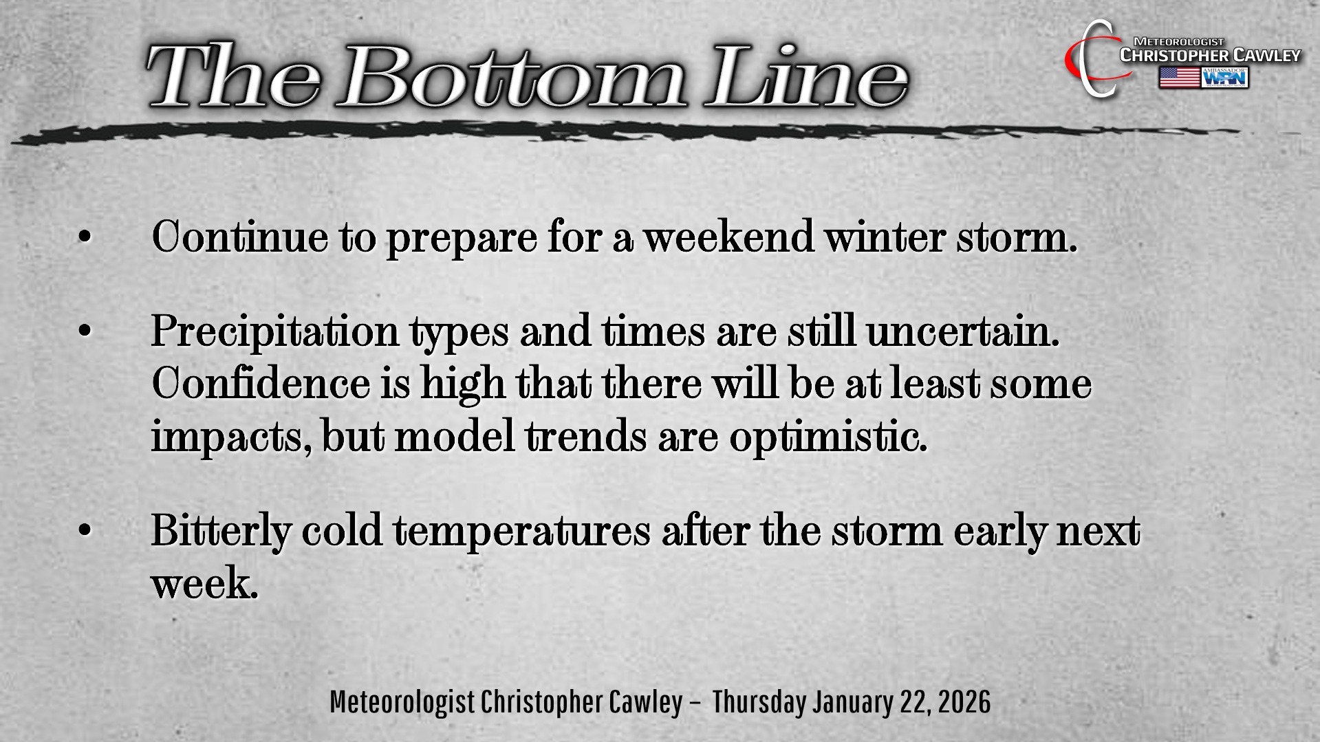
WINTER STORM THIS WEEKEND
WHAT IS KNOWN:
— Arctic high pressure brings extremely cold surface air to the area.
— A “fire hose” of deep moisture from the tropical Pacific ocean will lift across Texas through the mid-South to the mid-Atlantic.
— Low pressure area will lift along and off the coast Sunday evening.
WHAT IS NOT KNOWN:
— Location and track of the low pressure center.
— Dominant precipitation type (snow vs freezing rain vs sleet). This will be HIGHLY DEPENDENT on the ultimate storm track.
— Overall amount of precipitation.
WHAT SHOULD YOU DO?
— Continue to stay up to date with the latest information from the National Weather Service. Please check timestamps with all posts you see.
— Review your severe winter weather preparedness plan.
— Be prepared for an extended period of bitterly cold temperatures during and after the storm.
— Be prepared for possible power outages and difficult travel conditions.
OVERVIEW: What a difference a day makes. I’m “cautiously optimistic” based on the general model trends, but the “big two” (GFS and European) are a couple hundred miles apart as of this writing. That makes for a difficult forecast.
So let’s examine the ‘extremes’ between the big two:
SCENARIO #1: IF THE CURRENT GFS MODEL “WINS.” Significant ice storm for Columbus County and the surrounding area. The GFS continues to suppress the low farther south and east keeping colder air at the surface. Warm air pumps in higher in the atmosphere, resulting in freezing rain and possibly some sleet. GFS ensembles also want to paint a little bit of snow here, which would occur early on in the evolution of the system.
SCENARIO #2: IF THE CURRENT EUROPEAN MODEL “WINS.” Mainly rain by day with freezing rain and sleet during Saturday night. Overall ice accumulations less than a tenth of an inch, mainly confined to the northern half of the county. More “plain rain” than anything else.
I’m just not sold on this European deterministic solution. It wants to weaken the northern high just enough to lift the storm over the coast or perhaps just inland from the coast. The GFS keeps a strong Arctic high in place, suppressing things farther south and east.
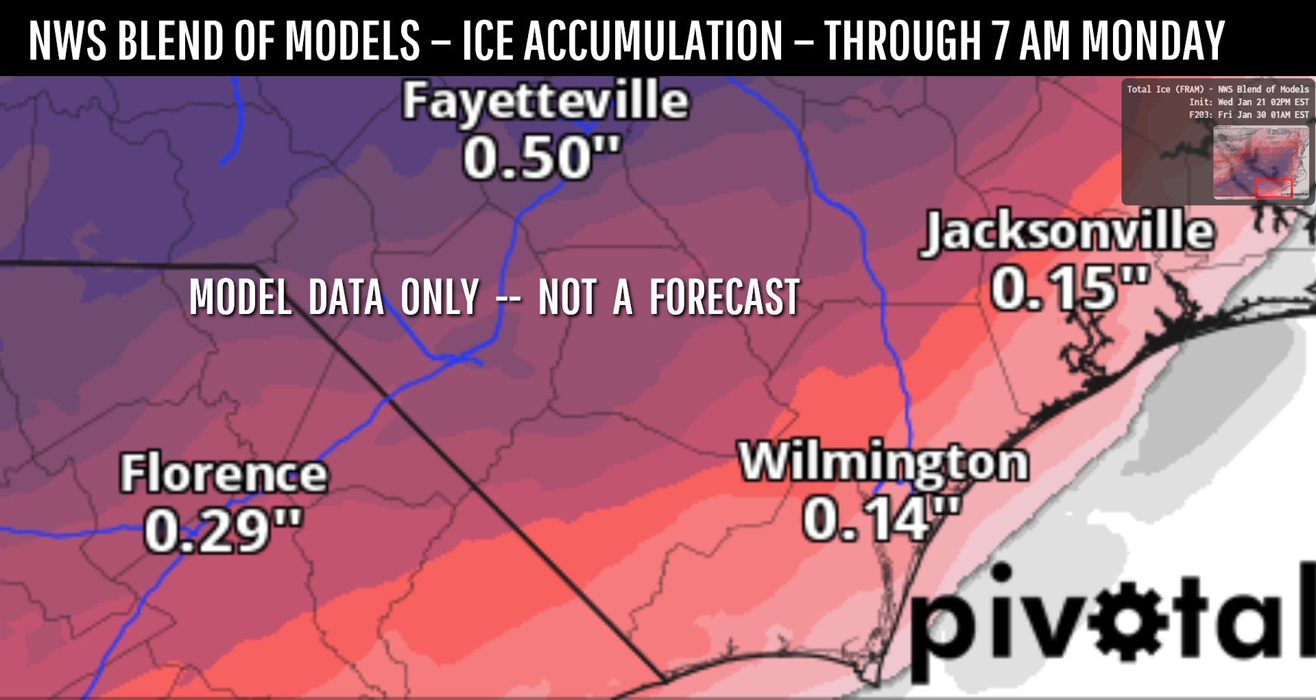
So let’s split the difference for right now… because as of right now I *think* that’s what the ultimate end will be. The latest NWS Blend of Models ice accumulation shows generally a quarter to a third of an inch of ice accumulation over the county… lighter amounts farther south and east, higher amounts toward Evergreen and the Robeson/Bladen lines.
NOTE —- THIS IS A MODEL, NOT AN OFFICIAL FORECAST.
It’s still too early to make a call and the variables at play are still significant. As of this writing, NOAA hurricane hunters are evaluating the storm system, and their analysis will get fed into the model computers, resulting in MUCH better modeling.
Such that by this evening I will be able to give a “first call” forecast.
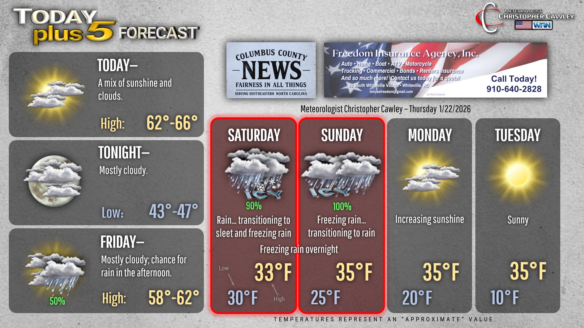
STORM EVOLUTION—As of early Thursday morning — SUBJECT TO CHANGE
FRIDAY AFTERNOON: Rain develops from southwest to northeast.
FRIDAY NIGHT: Periods of rain. There may be some freezing rain Friday night as lows drop to around 30.
SATURDAY: Rain transitions to freezing rain and sleet as temperatures fall to below freezing at the surface.
SATURDAY NIGHT: Periods of freezing rain through the night. Some sleet possible. Surface temperatures dropping to the mid 20s, but temperatures from the mid-levels of the atmosphere upward could be in the 40s to 50s.
SUNDAY: Freezing rain in the morning transitions to periods of rain around noon as surface temps nudge above freezing.
SUNDAY NIGHT: Periods of rain transitions back to freezing rain, tapering off after midnight.
MONDAY: Lingering freezing drizzle gives way to increasing sunshine, but cold temperatures.
This is all highly subject to change. A 50- to 100-mile shift in storm track will have tremendous ramifications on storm impacts here. The difference between cold soaking rain and a catastrophic ice storm.
Continue to make preparations for a severe winter storm. It may end up being a nothingburger rainstorm or it could be, like I said, a catastrophic ice storm.
I’ll know much more this evening, and again I plan on doing a Facebook Live probably around 7 PM this evening, where I will have a “first call” outlook.
For now, continue to prepare for the worst… hope for the best… and expect something in between.
Here’s your Freedom Insurance Today-plus-Five Forecast!
–Meteorologist Christopher Cawley