Good evening, Meteorologist Christopher Cawley here with your weather update for Thursday November 7, 2024.
Busted forecast, and I own it. According to Doppler radar estimates, very little rain fell across ColCo, while some higher numbers showed up for coastal Brunswick County. Dry air won the battle here, dry air that modeling struggled to latch onto. My mentor would tell me, “when in drought, predict more drought.” And the expected rainfall boost from Rafael didn’t materialize. Central South Carolina got soaked today… but once you cross the border into NC… barely anything. You win some, you lose some.
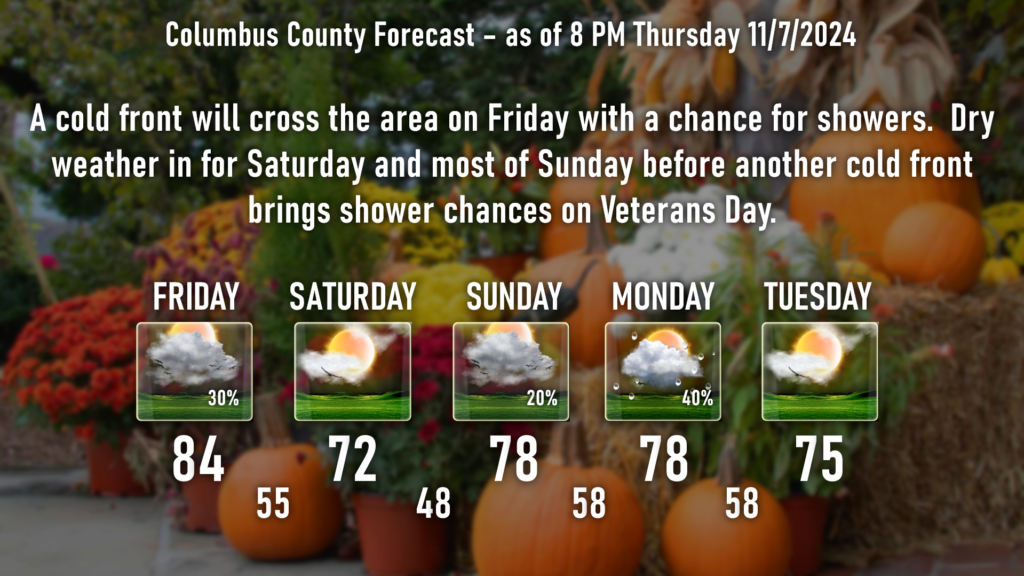
A cold front will cross our area during the day Friday. Some of the modeling suggests there may be some showers with the frontal passage. I’m not enthusiastic about that, especially given the Emmy-award-winning fail for the rain event thus far, but in my graphic I’ll put a “30%” for rain chances on your Friday.
Southwesterly winds ahead of the front will pump our temperatures to near-record levels. I’m going lower to middle 80s for ColCo, with temps leveling off by mid-afternoon.
Dry and much cooler for your Saturday with plenty of sunshine and highs around 70. Temperatures jump once again on a renewed southwesterly flow for Sunday and Veterans Day. Another cold front is likely to cross the area on Veterans Day, bringing a renewed chance for some showers. Again, I’m not overly bullish on these chances, but the modeling suggests there could be some rain, so I’ll go with it. Dry weather for the middle of next week.
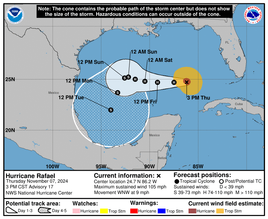
Tropics: Rafael has made a resurgence this afternoon. The hurricane has apparently mixed out some of the dry air from earlier today and become better organized, with a ragged eye that has emerged in satellite imagery and a more cohesive ring of deep convection surrounding its center.
The improved structure of the hurricane could make it more resilient to the negative effects of dry air and westerly shear in the near term, so some additional strengthening cannot be ruled out tonight. However, the overall model trends favor weakening through much of the 5-day forecast period as Rafael moves into a drier mid-level environment and encounters stronger shear by this weekend.
Rafael will continue a westerly movement in the Gulf, and the NHC expects this to continue into the weekend. There is a lot of uncertainty with a huge spread among the assorted models, and the NHCs forecast illustrates this with a huge uncertainty cone as we go into Veterans Day. The GFS and Canadian models want Rafael to turn northward again, becoming sheared to bits before making landfall along the Gulf coast. The European, UKMET, and regional hurricane models turn Rafael southward in response to a ridge of high pressure over northern Mexico. Honestly, we’re looking at a case of “6 of one, half a dozen of the other,” and ol’ Raffy could go either way. We’ll see. No threat to the Carolinas.
That will wrap up tonight’s update. Thank you for reading and as always, take care.


