Hi everyone, Meteorologist Christopher Cawley here with your CCN Weather Update for Friday December 27, 2024.
- Off-and-on showers today.
- Big-time warm-up Saturday through New Year’s Eve.
- Heavy rain potential on Sunday afternoon.
- Turning dramatically colder after the New Year.
- Could it snow? Maybe so…
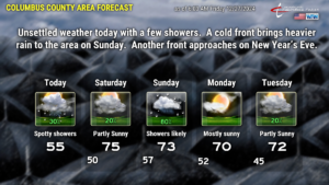
TODAY: A coastal frontal boundary has developed and is pushing inland. There is also a phenomenon known as “cold air damming” (CAD) keeping a shallow layer of relatively cold air trapped at the surface, while warmer air pushes from south to north higher up in the atmosphere. With the frontal boundary waffling over the area, this sets up an “overrunning” scenario, resulting in light rain showers. CAD is a situation that occurs when strong high pressure exists to our north, and there’s a northerly/northeasterly flow of cold air off the North Atlantic Ocean. This cold air becomes “trapped” at the surface over the Carolinas, and trapped against the mountains. It’s typically difficult to scour out, and these CAD events can last several days. Oftentimes they’re accompanied by cloudy, chilly, damp weather conditions at the surface — like today.
We’re not going to see a lot of rain today, just occasional showers. Modeling is too aggressive, in my opinion, in depicting the shower activity. Most of the moisture is trapped in this cold air close to the surface. To be honest, I’m not confident at all in this outlook … I’m going with “generalities” for today’s forecast by just saying “spotty showers” for today.
The temperature forecast is really tricky for today. That front is going to be the driver. West of the front, temps will be stuck in the upper 40s to mid 50s. East of the front, temps could jump deep into the 60s. There’s the potential that the front gets “hung up” somewhere over the county. In that scenario, Boardman would be 10-15 degrees colder than, say, Delco. The opinion of the NWS is that the front reaches the I-95 corridor … they’re going with highs in the upper 40s in Laurinburg to the lower 60s at Wilmington. I’m going to split the difference and put a “55” on the graphic for today.
As for sunshine today, that will also be highly dependent on where that front ends up. If the front pushes westward to I-95, as shown by modeling, then sure, we’ll have some partly sunny intervals this afternoon. If not, we’ll be stuck with lots of clouds and occasional showers through the day.
So for today, you’ll need a jacket, but probably not. Keep the sunglasses and umbrella handy. Sure.
TONIGHT: Tonight will stay mostly cloudy thanks to a lot of moisture in place. Winds at the surface will be calm, but go about a kilometer off the deck and we have a pretty decent southerly flow becoming established. There may be some patchy drizzle and/or fog overnight in that trapped colder layer at the surface.
SATURDAY: The front transitions to a warm front and dissipates as it flies northwestward. A robust southerly flow becomes established and our highs punch deep into the 70s. We’ll see more sunshine, but there’s also the slight chance at a few showers, especially during the afternoon hours… because YET ANOTHER coastal front comes together (thanks to the difference between the air/surface temperature over land and the colder ocean waters).
SATURDAY NIGHT: A better chance for showers exists as the second coastal front comes together and pushes quickly inland, transitioning to a warm front. This will funnel more moisture up from the south. The lows are going to be quite mild … mid to upper 50s … which is what our normal highs are this time of year.
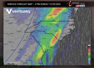
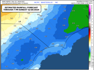
SUNDAY: This is the big day, the “weather alert” day. A strong cold front makes its way across the state. There will be a great deal of “forcing,” which leads to the best rain chances through my entire forecast. I’m putting 80% on my graphic for Sunday. The model blends are aiming between one-half and one inch of rainfall through Sunday, and I don’t see any reason to disagree with that. Some instability tries to push in from the south, but I think there’ll be enough stable air near the surface that rumbles of thunder will be rare on Sunday. There may be some gusty downpours Sunday afternoon as shown by the Ventusky map.
SUNDAY NIGHT INTO MONDAY: The front clears the coast Sunday night and there’s not much “cold” air behind this front … this time. Our highs Monday will be a few ticks cooler than over the weekend, but still running quite a bit above normal for the end of December.
Our next system arrives fairly quickly with shower chances on New Years Eve and New Years Day with the passage of another cold front. This time… there will be cold air pushing in behind it. Way colder.
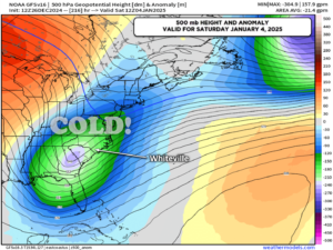
LONG-TERM: After the New Year, Arctic air pushes southward and locks in for the entire eastern seaboard, including Florida. A deep trough becomes established in the upper levels of our atmosphere, as shown on the map below:
This upper-level troughiness and colder air is likely to remain in place through the middle of January. There will be some “waves” where our highs approach normal, but on the whole, colder-than-normal temps are expected. The long-range modeling, European and GFS, points to a few weather systems of interest that may impact the east coast. Now, I say this with a caveat — any modeling beyond about 7 days out is a crapshoot at best. A shot in the dark. HOWEVER, IF….IF a system can fire up on the southern branch of the jet stream during this cold streak, it could lead to some snowfall here in Columbus County. This is all speculation at this point, but the latest European ensembles has 18 out of 50 “runs” indicating some measurable snow here between Old Christmas and January 10th, and the GFS control shows a southern-stream system coming together at about that same time frame.
Again… this is so far out in time that it’s almost laughable to call, but there is little doubt that the cold air will be in place. All we need is something to spin up and slip off the coast for things to get interesting if you’re a fan of winter weather.
That’ll do it for today’s post, thank you for reading and, as always, take care!

