Happy Sunday everyone, here’s your CCN Weather Update.
This weather update is brought to you by our friends at Freedom Insurance in Whiteville. When severe weather strikes, have the peace of mind that your vehicles and property are well covered. Visit our office for comprehensive policy quote that will fit all of your needs. Call us at 910-640-2828 or stop in at the south end Hills shopping plaza.
STATISTICS FOR WHITEVILLE – Saturday March 1, 2025.
High: 78.6°F at 3:33 PM (normal is 61)
Low: 49.4°F at 7:13 AM (normal is 36)
Precip: 0.00 in
View live, real-time weather data for Whiteville on my College Street Weather Station.
Here’s your Bottom Line for today…
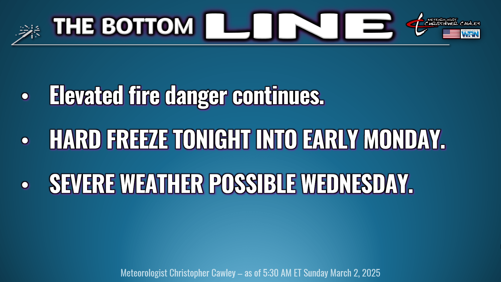
Elevated fire danger continues today. Even though it’s going to be a LOT colder with light winds, ground debris is still extremely dry and even so much as a cigarette butt thrown out the window of a car can ignite a ditch, which can spread into the brush and trees very quickly.
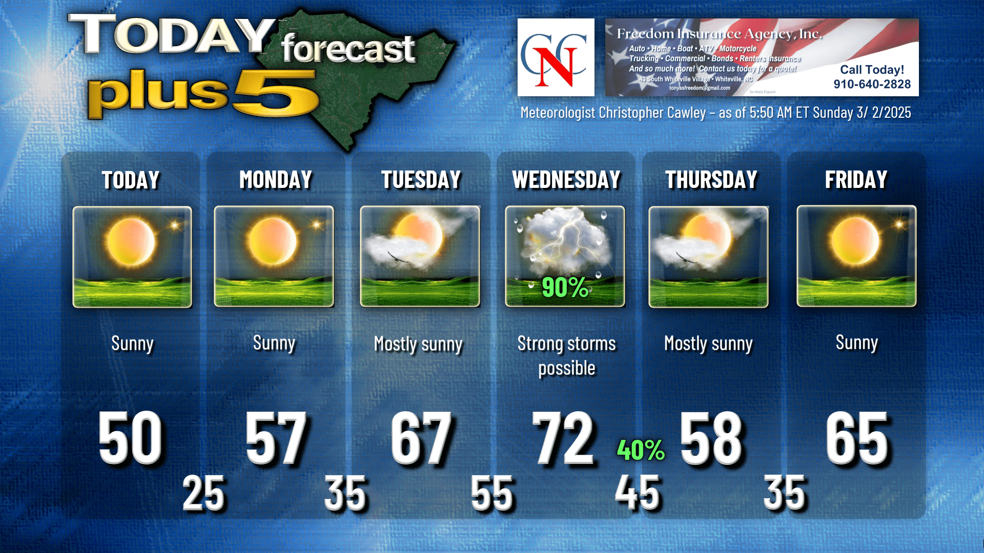
There’s not a whole lot to talk about in the weather department today. Strong high pressure of Canadian origin will dominate the weather for most of the eastern half of the country today into tomorrow. As a lobe of this high pressure moves overhead tonight, with calm winds and clear skies, picture-perfect radiational cooling takes place.
A hard freeze will occur tonight with lows generally in the middle 20s across Columbus County.
Slightly milder conditions on Monday as winds start to veer to the south… but we will still be running several degrees below normal.
Meanwhile, a complicated set of low pressure cells will be coming together over the Rockies.
By Tuesday, the high is well off the coast, as the spicy storm system becomes one low center of impressive strength over Kansas. This storm center will lift northeast toward the Great Lakes by Tuesday night. Warm front lifts north over the area by daybreak on Wednesday, and this may bring a period of rain and embedded thunder.
SEVERE WEATHER THREAT WEDNESDAY
Our area is firmly entrenched in a robust southwesterly flow of Gulf origin. The low center lifts up the St. Lawrence valley while a powerful cold front approaches from the west.
A line of showers and thunderstorms is expected Wednesday afternoon ahead of this front. A very strong low-level jet of 70-80 mph (at about 5,000 feet) will result in strong surface winds. Whatever storms pop into that shear level could produce damaging winds at the surface at or above 60 mph.
The biggest variable in our forecast for severe weather is that of instability. Modeling is not really consistent as to what instability will be in place. If we break out into some sunshine during the mid- to late-morning hours on Wednesday, that will greatly amp up the instability numbers… and a more organized severe weather event will take place. If the convective line is slowed a bit and therefore moves through during the evening hours, the severe weather threat is lower… as well as if the convective line races through during the morning or early afternoon.
For all you weather nerds out there, the WPC is predicting the center low to reach a pressure of 984 mb, which is equivalent to 29.05 inHg barometric pressure. For reference, a typical tropical storm center has a central pressure of around 980 mb. This storm on Wednesday is going to be a brute.
Here’s your Freedom Insurance Today-Plus-5 forecast for Columbus County.
That’ll do it for today. Thanks for reading, and as always, take care!
~Meteorologist Christopher Cawley