Greetings folks, welcome to your CCN Daily Weather Update for Saturday March 15, 2025.
This weather update is sponsored by Freedom Insurance of Whiteville. Contact Freedom today for all of your insurance needs. Their professionals are 100% committed on providing outstanding customer service and working with you to establish the best policy to meet your needs.
STATISTICS FOR WHITEVILLE – Friday March 14, 2025.
High: 72.8°F at 4:49 PM (normal is 65)
Low: 47.7°F at 7:33 AM (normal is 40)
Precip: 0.00 in
View live, real-time weather data for Whiteville on my College Street Weather Station.
Here’s today’s Bottom Line
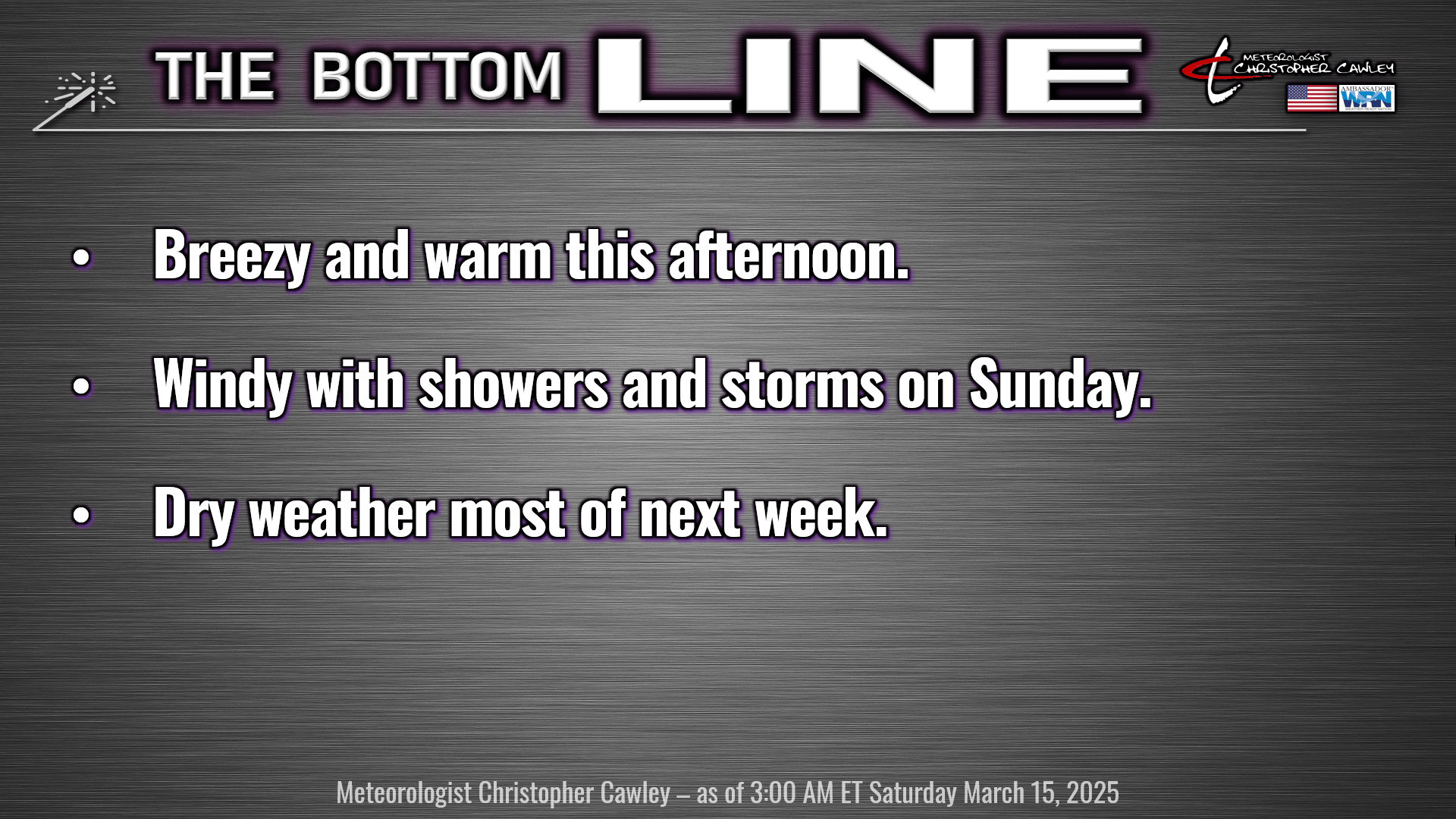
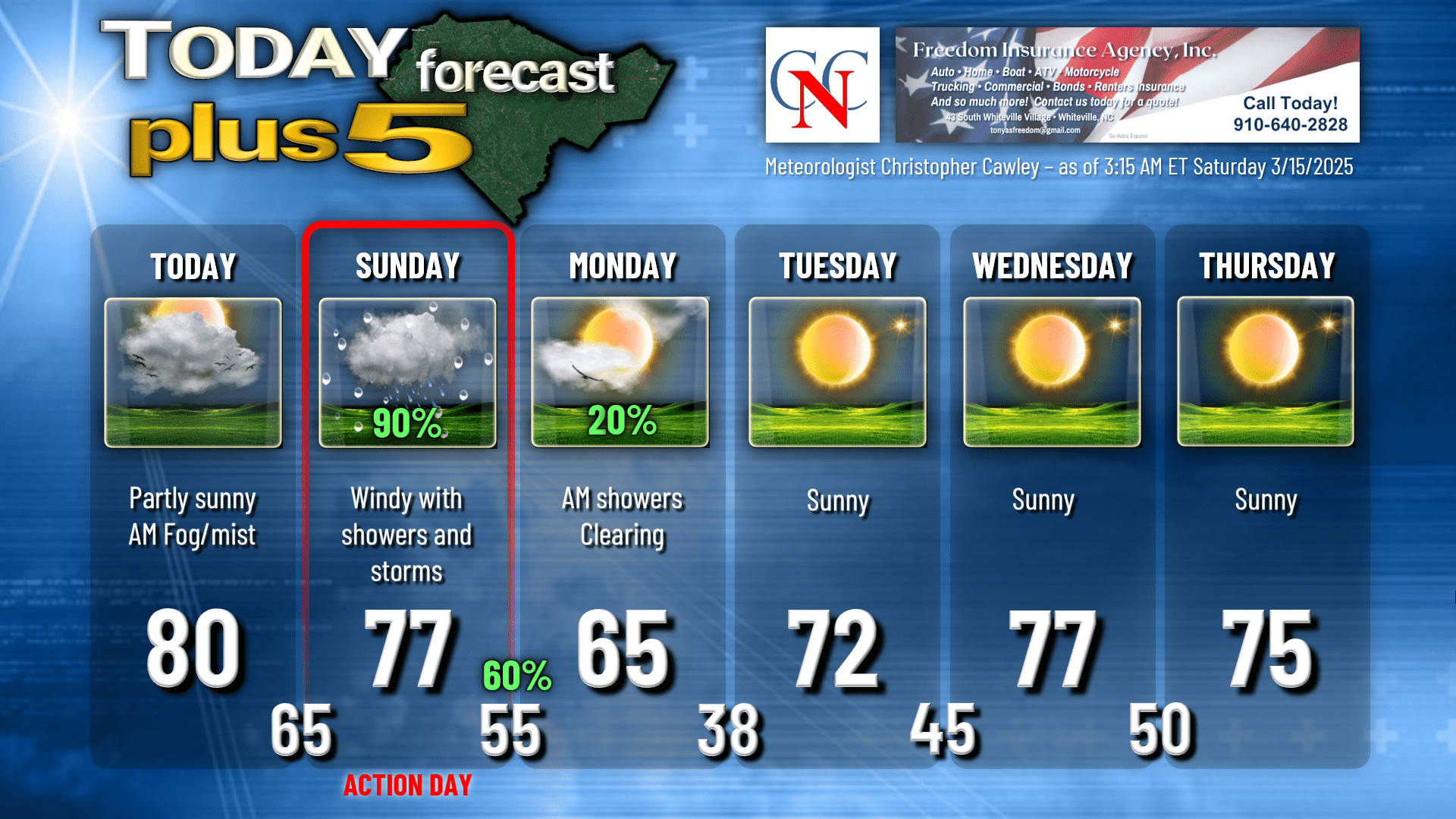
We’re starting off with some cloudiness, areas of fog, and some drizzle this morning, but I expect this to be a memory by the mid-morning hours. We’ll have a mix of sunshine and clouds today, becoming breezy this afternoon, and a high near 80.
It will become rather windy during the overnight tonight, but I believe we’ll stay dry. Our lows early Sunday will be closer to our normal highs… mid 60s.
WEATHER ACTION DAY — SUNDAY. A strong low-level jet (60-70 mph at about 2500 feet) will become established resulting in windy conditions here at the surface. A line of convection will work its way across the state ahead of a strong cold front.
The Storm Prediction Center maintains our area in a level 2 out of 5 risk for severe weather on Sunday. I think the marine air layer (ocean air layer, which is cold and very stable) is going to wreak havoc with any severe activity. Guidance suggests that there will be some instability present, but ultimately I’m not of the overall opinion that we’ll see much, if any, severe weather across Columbus County.
Go WEST of I-95 and you have an entirely different story with damaging winds, hail, and tornadoes a threat.
But we don’t live west of the 95, we live east. And I’m going to circle back to that marine layer of air that will likely be spread pretty thick over the county.
Honestly I don’t even think we’ll see a lot of lightning with the activity Sunday afternoon.
I expect “convective showers” (with some heavy rain elements) to be across the area from roughly noon Sunday into Sunday evening. Wind gusts OUTSIDE of these showers will likely be in the 30-40 mph range; however, inside some of the stronger convective cells, winds could gust 50-55 mph.
While there is the chance that we could see severe-rated wind speeds (58 mph or higher)… I really doubt it.
The parent cold front crosses the area Sunday evening. There may be a secondary line of showers with the actual frontal boundary, but by this time, any severe threat is a memory.
The actual large-scale trough that will be the driving force behind the front won’t actually clear our area until mid- to late-morning on Monday. Until then, lots of clouds and occasional showers remain a possibility. After that trough clears the coast, our skies will rapidly clear, humidity values drop like a rock, and colder air comes rushing in from the west-northwest.
Monday’s temps look to be seasonable, while Tuesday through Thursday will be quite warm once again. We cool off behind a dry cold front by next Friday, and there’s a very slim chance for some isolated frost late next Friday night / next Saturday.
Here is your Freedom Insurance Today-plus-Five forecast for Columbus County.
That will conclude today’s report. I look forward to seeing you at Southern Farm Days today!
~Meteorologist Christopher Cawley