CCN Weather Update for Monday June 9, 2025.
This weather update is sponsored by Freedom Insurance of Whiteville. When severe weather strikes, with Freedom Insurance you will always be prepared. For home, car, boat, or whatever you need, Freedom can provide customized coverage to keep you and your family safe. Contact Freedom today at 910-640-2828!
Here’s today’s Bottom Line

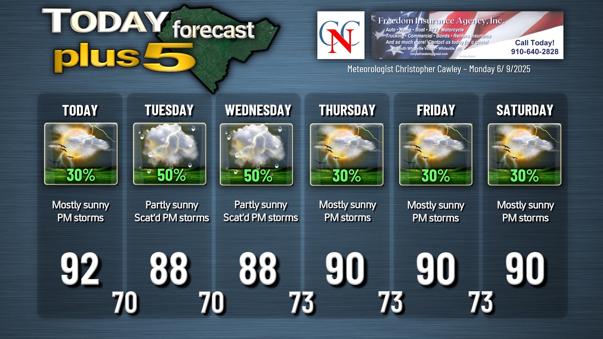
Unsettled weather is likely to occur through the entire work week. A frontal boundary will linger just to our west and an upper-atmosphere trough (essentially an area of “low-ish” pressure) to our east. We’re kind of stuck in the middle of all of this, and isolated to widely scattered thunderstorms are possible this afternoon in a relatively unstable atmosphere. Our highs today should be around 90 or possibly into the lower 90s, with heat index values in the upper 90s to around 100.
The frontal boundary to the west, and trough to the east, are going nowhere fast. The front will tend to inch closer to our area on Tuesday, and therefore I expect a bit better coverage of afternoon showers and thunderstorms Tuesday and Wednesday. Considering that we’ll have a bit more cloud cover, I expect our highs to be a tick or two cooler, but the heat index values will still average out in the mid to upper 90s. Increased coverage of storms = increased severe weather risk, and if the storms can become somewhat organized, another MCS could occur, similar to what we experienced on Sunday.
The frontal boundary will tend to retreat a little bit back to the north and west going into Thursday, Friday, and Saturday. Since the trough will still exist to our east, albeit in a weakening form, I still expect isolated to widely scattered “popcorn” style showers/storms in the afternoon. Highs jump back to around 90 or in the lower 90s for the late-week period, with heat index values in the upper 90s to around 100.
The overnight hours each night this week will feature evening thunderstorm chances, and then variably cloudy skies, humid conditions, and lows in the lower 70s.
Any storm that forms at any time, at any location this week could briefly reach severe limits with damaging winds and hail. The lightning threat with storms this week will remain excessive.
TROPICAL OUTLOOK: All remains quiet over the tropical Atlantic, Caribbean, and Gulf; no systems are expected to develop over the next 5-7 days. Tropical storms Barbara and Cosme exist west of Mexico in the eastern Pacific, obviously not an issue here.
Here is your Freedom Insurance Today-plus-Five Forecast:
–Meteorologist Christopher Cawley