CCN Weather Update for Friday June 20, 2025.
This weather update is sponsored by Freedom Insurance of Whiteville. When severe weather strikes, with Freedom Insurance you will always be prepared. For home, car, boat, or whatever you need, Freedom can provide customized coverage to keep you and your family safe. Contact Freedom today at 910-640-2828!
High temperature at College Street in Whiteville on Wednesday was 94.5°F. The highest heat index was 106.8°F.
View real-time data from the weather station at College Street Weather Station.
Here’s today’s Bottom Line
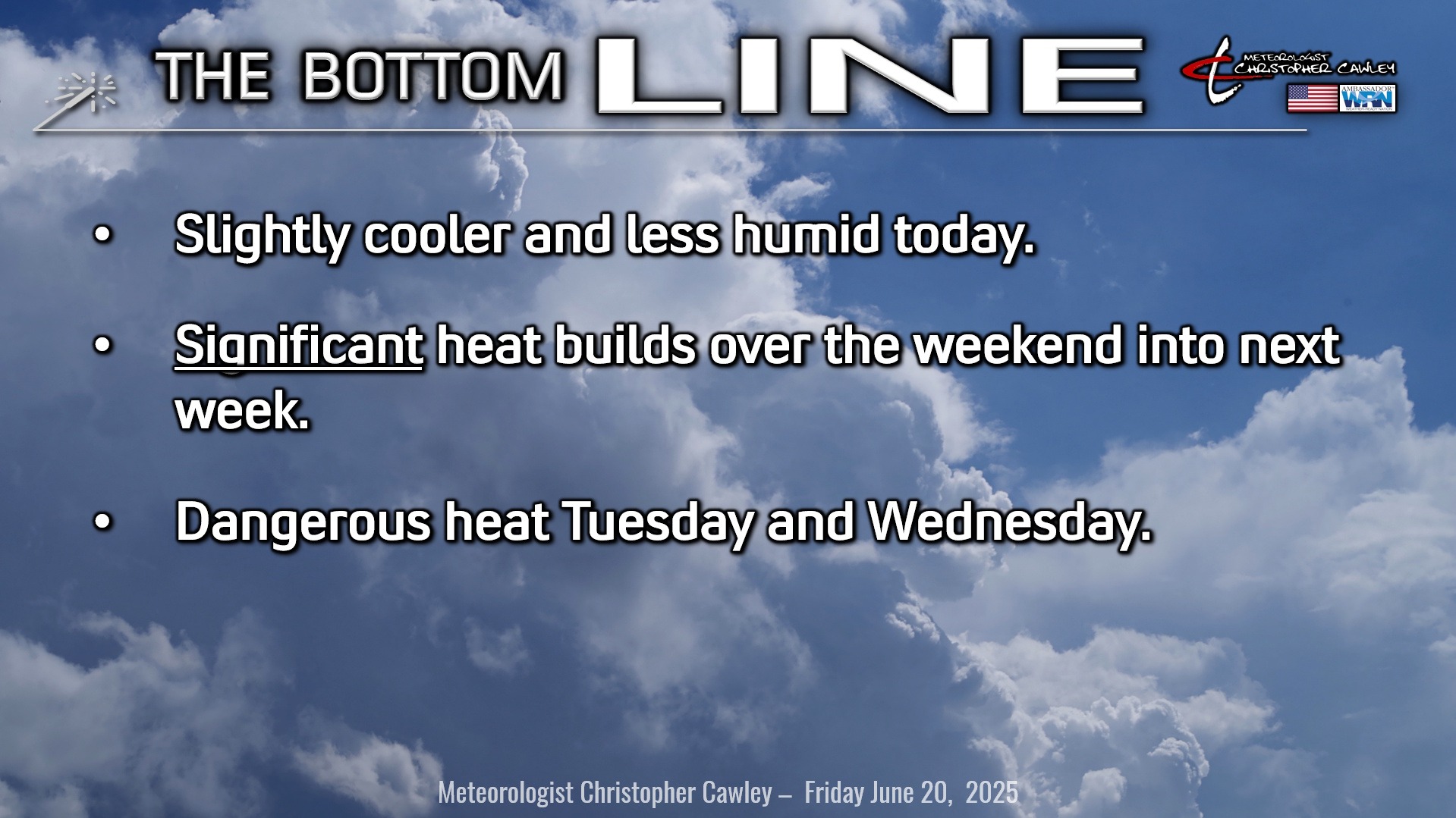
Today will be the coolest day temperature-wise for at least the next 7-10 days.
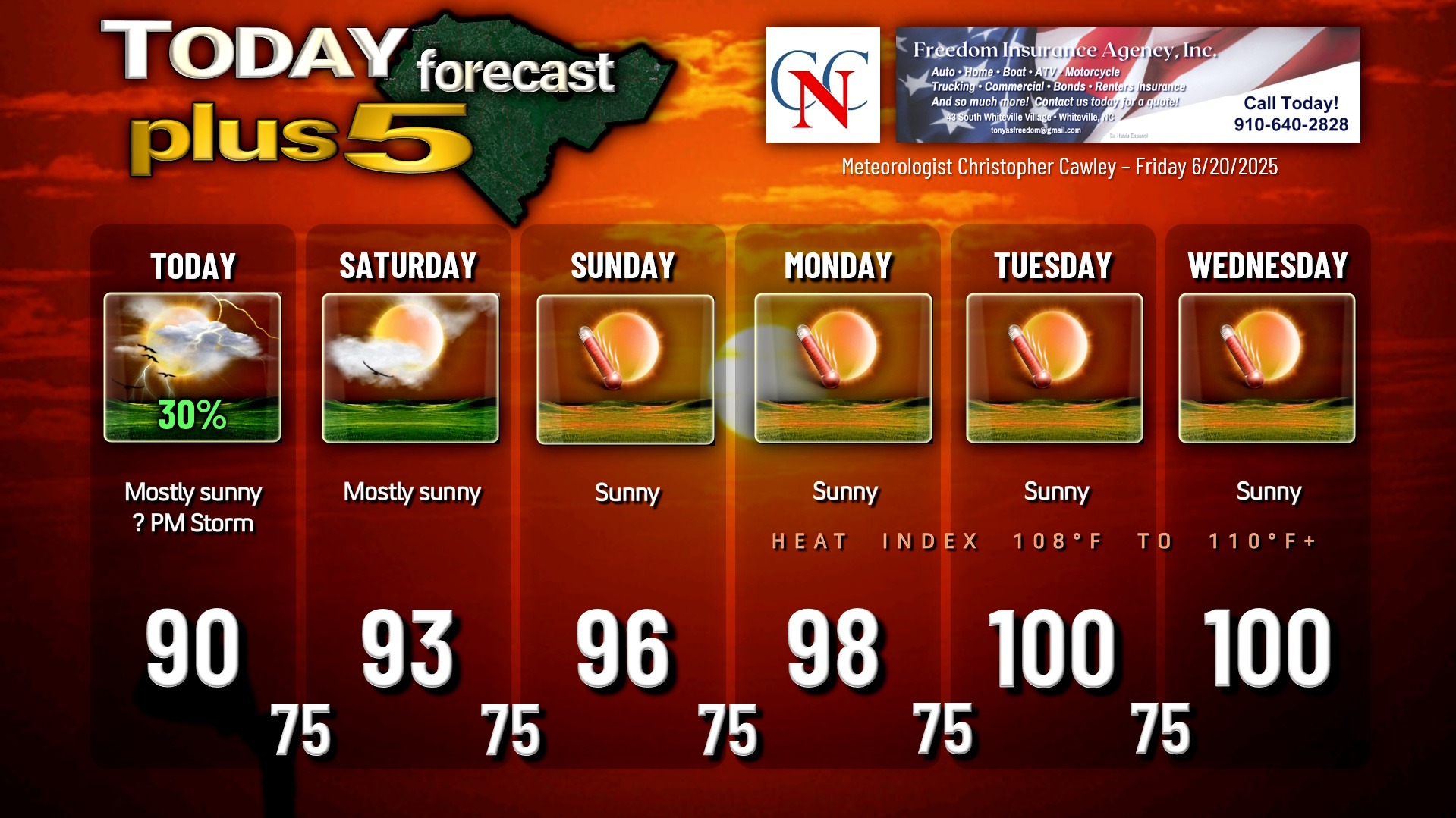
A weak cold front is moving through the county this morning. On the whole today we’ll see mostly sunny skies, but enough destabilization may occur that a few thunderstorms form on the sea-breeze boundary this afternoon. I’m not excited about those chances, but it could happen, so I put a 30% on the graphic.
That will conclude our rain chances for the foreseeable future.
High pressure starts to take control on Saturday. Temps start to increase. An isolated sea-breeze storm may develop Saturday afternoon.
Then the heat furnace takes over. A large ridge of high pressure, extending from the surface through the middle and upper levels of the atmosphere, will form a “heat dome” over most of the eastern United States for next week.
Triple-digit heat is now expected over Columbus County on Tuesday and Wednesday of next week.
That does not count the heat index… which could push north of 110°F. NWS Heat Advisories are almost a certainty at this point for Monday through Wednesday… but should the heat index values start pushing the 110s, “excessive heat warning” criteria would be reached.
As for rain chances, close your eyes and tell me what you see: Nothing. Especially in the Monday-Wednesday timeframe, where even clouds will be hard to come by. Perhaps some cirriform clouds early in the morning hours.
The low-pressure cell off of Myrtle Beach that I noted in yesterday’s report is not being shown on any of the modeling at this point. The ridge of high pressure is just massive, and it doesn’t make any sense that a low-pressure wave would form “underneath” this ridge. The only precip chances will be in what is known as a “ring of fire” around the periphery of the high, which does not include our area, at least through Wednesday. The high may start to shift eastward by the second half of next week, lowering our temps and increasing our thunderstorm chances.
Anyway… if you thought the last few days were hot… just wait.
TROPICAL OUTLOOK: As noted, the low-pressure center shown on modeling yesterday is no longer showing up. The NHC maintains their forecast that tropical cyclone activity is not expected during the next 7 days.
Here is your Freedom Insurance Today-plus-Five Forecast:
–Meteorologist Christopher Cawley