
2025 Weather Year in Review – Whiteville and Columbus County, N.C.
Special contributions Nathan W. Cawley
The year 2025 brought a snowstorm, flooding, extremely cold temperatures, and extremely hot temperatures to Columbus County and southeastern North Carolina in general.
This report will be a month-by-month breakdown of weather events for Whiteville / Columbus County in the year 2025.
JANUARY: Low pressure on the southern jet stream… combined with an Arctic air mass overhead… led to the biggest snow event in many years. What started off as an expected “trace to 1 inch” snow event ended up with generally 5-7 inches of snow across the county, with about 6 inches measured in uptown Whiteville. Snow began to fall on Tuesday Jan. 21 and fell quite heavily late in the evening and into the overnight, leaving a fun blanket of white the likes we hadn’t seen in many years.

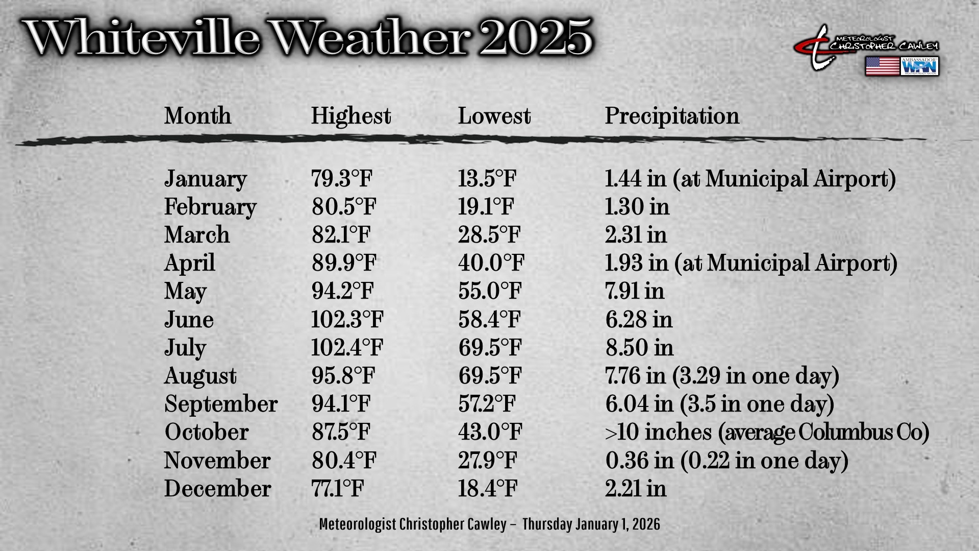
Otherwise January was rather uneventful in the weather department. There was roughly an inch and a half of liquid equivalent precipitation for the month (note, there was a precipitation data gap for KNCWhite8, the weather station owned by Meteorologist Christopher Cawley — precipitation numbers will be approximate where noted). Liquid equivalent precipitation was measured at 1.44 inches at the Columbus County Municipal Airport.
The highest temperature recorded in January was 79.3 on Jan. 31, while the coldest was 13.5 degrees during the night of Jan. 22.
FEBRUARY: There were no significant weather events. The area experienced above-normal temps through the month, with the highest temperature being 80.5 on Feb. 27. Our lowest was 19.1, and the city received 1.30 inches of rain for the month.
MARCH: While we didn’t receive a lot of rain in the bucket, March was an active month for weather, with severe weather and fire concerns during the month. There were several active weather days, the most notable producing severe winds about the area, prompting several severe thunderstorm warnings. We had a high temperature of 82.1 on March 31, with a low of 28.5 on March 3, and the total rainfall was 2.31 inches.
APRIL: What is typically the peak month of severe weather season was rather underwhelming across the county. A squall line on April 5 brought some damaging winds to the county as well as a landspout report and a tornado in Pender County. (A landspout is like a tornado, only that it forms from the ground and extends toward the cloud base, where a tornado is the other way around). Total rainfall measured at the airport was 1.93 inches for the month of April. The highest temperature on the KNCWhite8 weather station in uptown Whiteville was 89.9 degrees on April 31 with a low of 40.0 on April 13.
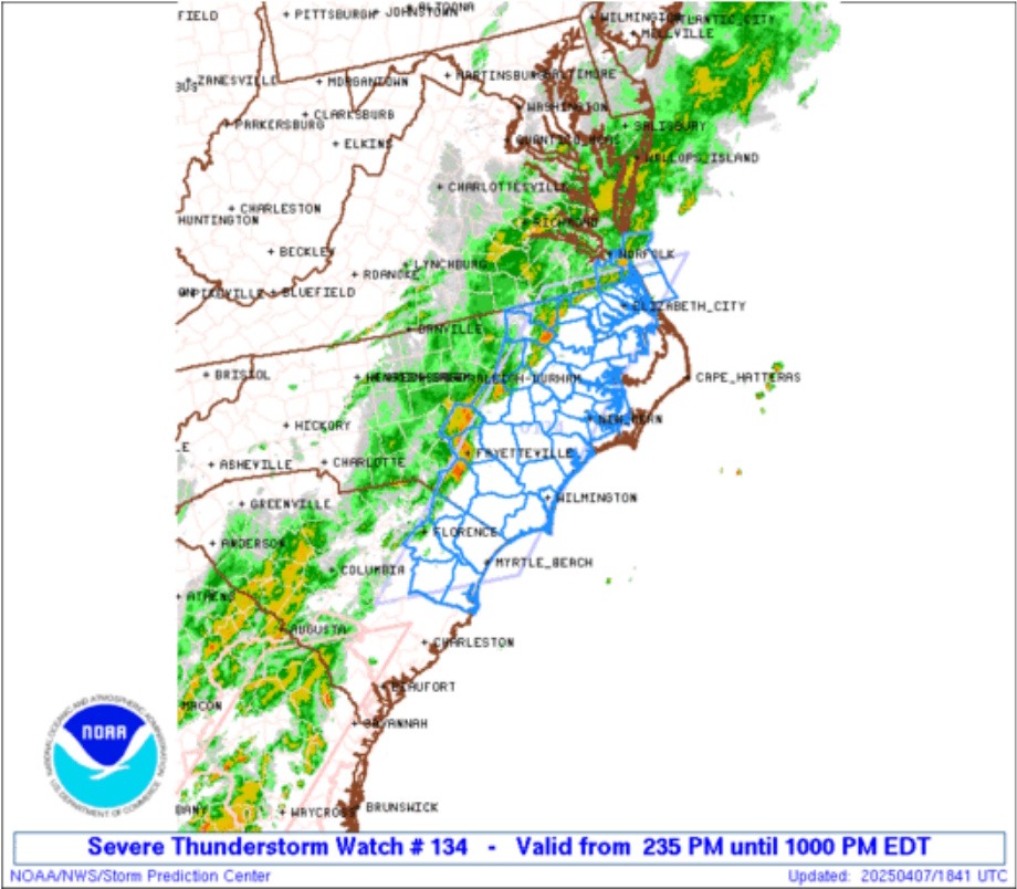
MAY: Business picked up pretty good during the month of May. There were severe weather risks outlined by the Storm Prediction Center on 18 out of the 31 days in May. Events of note include a severe storm that produced hail in the city on May 14, and a tornado-warned storm that produced a funnel cloud near Cerro Gordo. It also got hot during the month of May, with the temperature peaking at 94.2 on May 16. The total rainfall for the month was 7.91 inches.
JUNE: A story of hail and heat. Quarter-sized hail hit the majority of the area on the night of June 1 around 8:30 p.m. as a severe thunderstorm blew through the area. No damage was reported, but there were several reports of quarter-sized hail throughout the county. Widespread damaging winds and severe thunderstorms also occurred on June 25, with the NWS receiving reports of large hail from St. Pauls to Clarkton. The Columbus County Municipal Airport received a wind gust of 48 mph. Outside of this, there were several typical summertime pulse storms. The heat cranked into full effect from June 22-25, with the highest temperature recorded of 102.3 degrees on June 25. Total rainfall was 6.28 inches.
JULY: Flood woes begin across the city … much publicized flooding woes. The month was characterized by Tropical Storm Chantal and slow-moving, pulse thunderstorms across the county. Chantal produced rainfall of approximately 4-6 inches about the area. Then, on July 10, a thunderstorm produced flooding through the city. This, unfortunately, would only be the first of several flooding events in Whiteville and Columbus County in 2025. July was also hot, with the temperature cresting at 102.4 on July 27; the lowest was 69.5 on July 23. The thunderstorm of July 10 produced 2.53 inches of rain in a few hours (resulting in the flooding), while the monthly rain total was 8.50 inches.

AUGUST: August was rainy to start, hot at the end. Flooding woes continued at the start of the month, with yet another flooding event throughout downtown and on side streets on Aug. 6, where over 3 inches of rain fell within about a one-hour time-span due to slow-moving pulse thunderstorms. Outside of the typical summertime pulse storms, the flooding on Aug. 6 was really the only remarkable weather event of the month, as it became hot and dry through the remainder of the month with quite a few consecutive days where the high was north of 90. The highest temp was 95.8 on Aug. 18, with the lowest being 69.5 on Aug. 28. The total measured rainfall was 7.76 inches, with 3.29 of that falling on Aug. 6.
SEPTEMBER: The dry weather came to a screeching halt on Sept. 7 when yet ANOTHER flood event occurred in Whiteville. Over 3.5 inches of rain fell during a storm that day, causing flooding through several poor-drainage areas across Whiteville. The highest temperature in September was 94.1 degrees on Sept. 6, with a low of 57.2 on Sept. 17. Total rainfall was 6.04 inches.
OCTOBER: Nor’easter storm causes major flooding throughout Columbus County. The story of the month of October was a bomb nor’easter that produced 6 to 10 inches of rain across the county on Oct. 12, which prompted water rescues in Chadbourn, Whiteville, and Tabor City. Whiteville’s downtown was once again hit especially hard due to an intense, stationary rain band that became established. Several businesses were inundated across downtown Whiteville, and reports of up to 18 inches of standing water were received in Chadbourn. Most unfortunately, exact rainfall totals for the month are missing; several weather stations about the area had data gaps. The municipal airport received just under 8 inches of rain for the month. Temperature data is available, though, and we had a high of 87.5 on Oct. 6, with a low of 43.0 on Oct. 31.
NOVEMBER: The month of November provided some peace and quiet to the region. It was an exceptionally dry month, with only 0.36″ rainfall measured (of which 0.22″ fell on Nov. 2). Temperatures were also all over the map, with large swings throughout the month.
Interestingly, the earliest reported snowfall occurred about the area on Nov. 10, with trace accumulations in Lumberton and Wilmington, and NUMEROUS reports of snow falling about Chadbourn and Whiteville. The highest temp in November was 80.4 on Nov. 9, with the lowest coming in at 27.9 on Nov. 29.
DECEMBER: We experienced one of the warmest Christmas Days in recent history, with the high temperature of 77.1 degrees (which was also the highest for the month).
December was a dry month, with only one “major” (not really) rain event for the entire month. Like November, temperatures were all over the place through the month, again culminating on Christmas Day.
SUMMARY:
–Special thanks to Nathan Cawley for extraordinary record-keeping through the year.