Hi everyone, Meteorologist Christopher Cawley here with today’s weather update. This one’s kind of long folks, strap in.
Today is a “Weather Action Day.”
No, we’re not looking at any crazy widespread severe weather event (or at least I HOPE not). We do have a significant cold front which will rocket across the county today. This front is part of a gigantic cluster of storm systems and trough that extends through multiple levels of the atmosphere, impacting the entire east coast from the Great Lakes to New England southward to the Florida Keys. This trough becomes “negatively tilted.”
This is significant, so let’s talk some Science.
A trough is representative of low atmospheric pressure and stormy conditions. There are several different types, including longwave, pre-frontal, shortwave, positive-tilt, and negative-tilt.
The tilt of a trough is the angle the trough axis (center) makes with lines of longitude. A negatively tilted trough tilts horizontally (parallel to surface) from the northwest to the southeast.
“Ok, Chris, that’s great, so what does THAT mean?”
A negatively tilted trough can indicate that an area of low pressure has reached it’s peak strength. Except… in today’s case… we have three distinct areas of low pressure feeding our system. Anyway, the trough increases atmospheric instability, and indicates good vertical wind shear (a change with wind speed/direction with height).
A negatively tilted trough can cause severe weather outbreaks during the warm season, especially when they’re combined with deep low pressure.
In short, this is an unusually strong weather system for time of year, and will impact the entire east coast.
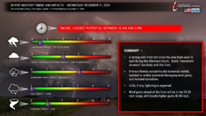
WIND: The arrival of the trough will bring very strong winds to certain levels of our atmosphere. If we were to go about 3,000 feet off the ground, winds will be peaking between 60 and 90 mph. With the front comes a lot of “lift,” which will result in a line (or a few broken lines) of strong “convective showers.” The “convective showers,” as they move through, will work to “mix down” some of these stronger winds that I mentioned toward the surface. Wind gusts will reach their peak just ahead of the frontal boundary. Most areas will see wind gusts in the 30-40 mph range but I wouldn’t be surprised to see gusts pushing 45 mph just as the front is about to move through. This may trigger a few spotty/isolated power outages, along with some downed tree limbs and Christmas decorations being blown about. There is the chance for ISOLATED wind gusts of 60+ mph in the convective showers.
THUNDERSTORM THREAT: What we’re looking at today will be “convective showers” — that is to say, thunderstorms without the thunder and lightning. That being said, there is a severe weather risk across the county for today. As mentioned, we will either have one convective squall line, or perhaps a few more broken lines, move across the county today. The NAM3k model shows two lines of very strong convection moving through between 10 AM and 3 PM. The latest HRRR shows one larger convective line rocketing through here around lunchtime… and off the coast by about 2-3 PM.
Both models are indicating just bonkers amount of vertical shear, but negligible instability. What the models don’t pick up on at all, and further muddying the waters for Columbus County, is where the stable ocean air layer lies. Ocean water temps are in the 50s, and that will work to really put a lid on any instability. There are times when that stable layer of air can push as far inland as the I-95 corridor. However, in today’s case, the very strong southerly winds, along with the potential for breaks in the clouds, may “push” that stable air layer closer to the coast, and out of ColCo. No matter what, I still think that instability is going to be lacking on the whole.
Let’s say that there are enough breaks of sunshine that the atmosphere destabilizes. It won’t destabilize wherever the marine (ocean) layer exists. Precisely where this stable layer sets up will be the “line of demarcation” where severe weather can occur today… and is virtually impossible to predict. If the stable layer takes up residence across ColCo, that means pretty much zero severe weather threat. If that ocean air pushes more toward Brunswick and New Hanover counties, then the threat for damaging wind gusts over 60 mph and isolated tornadoes increases across ColCo.

There’s the chance (a low chance) that “discrete,” or isolated convective cells form ahead of the actual line and frontal boundary. In the spring and summer, this would be a supercell storm threat. In December, it’s just more “convective showers” with a higher probability of tornadoes.
My forecast confidence is probably an 8/10.
CERTAINTY: Periods of rain today, possibly heavy at times.
CERTAINTY: Windy conditions; gusts 25-35 mph possibly as high as 40-45 mph.
LESS CERTAIN: Severe weather threat.
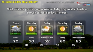
All of this is a memory by this evening as the front pushes well offshore and COLD air comes sailing in on a west/northwest wind flow. High pressure builds in from the north, and Thursday’s highs will run some 15-20 degrees colder than what we experience today. We’ll be lucky to reach the 50-degree mark Thursday afternoon.
Skies are clear and winds go calm Thursday night… lows will be in the upper 20s to lower 30s. Friday will feature temps in the lower 50s.
Our next warm-up occurs Saturday as a warm, moist flow starts to become established… ahead of yet another cold front which is slated to cross late Sunday or Sunday night. This front doesn’t appear to be nearly as strong, and temps behind it shouldn’t be all that bad.
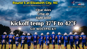
WOLFPACK WEATHER: Heading to Round 5 in Elizabeth City, we’re going to be high-and-dry… but cold… as temps will be generally in the upper 30s to around 40 at kickoff, dropping to the lower 30s by the time the game ends.
Whew. You made it all the way through this lengthy update. Thank you for reading, and I hope you all have a fantastic day.

