Greetings everyone, Meteorologist Christopher Cawley here with your CCN Weather Update for Friday January 3, 2025.
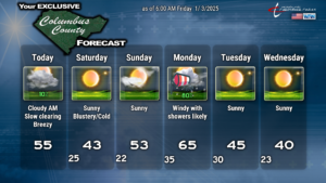
A little bit breezy and cloudy to start our day today, but this should gradually clear out this afternoon. It’ll become rather breezy ahead of a cold front that should cross the area around suppertime. The front has very little moisture with it. The cloudiness this morning may produce a very light, isolated sprinkle but I doubt it. Winds will pick up this afternoon and should peak during the mid- to late-afternoon hours.
Skies become clear and temperatures tumble tonight. Breezy conditions continue tonight and Saturday thanks to a deep cyclonic flow over the eastern US. It’ll be blustery at times with lows early Saturday in the mid 20s, with afternoon highs struggling to the lower 40s. Wind chill values early Saturday through about noon will be in the 20s, so dress appropriately if you have any outdoor plans.
Winds die off Saturday night and that sets the stage for good radiational cooling. Lows should drop to the lower 20s for most of the county. Some typically colder spots my dip into the upper teens.
Sunday will feature sunshine, with some increasing cloudiness late in the day as a significant weather system sets its sights on the east coast. A southwesterly wind flow becomes established ahead of this storm system, and that pushes our highs into the lower and middle 50s on Sunday. There is very good agreement on both the control and ensemble model sets… so I’m going with it.
Things get active Sunday night and Monday. Low pressure will move northward over the central Appalachians to a position off the Jersey coast by Monday afternoon. A warm front lifts over the area Sunday night with rain developing. All modeling and all atmospheric temperature profiles points to this being a rain-only event. Our temperatures will probably rise during the overnight Sunday night into Monday morning, with early lows in the lower to middle 30s… but by time you send the kids back to school on Monday we should be in the 40s, perhaps closing in on 50.
Monday will be a windy day with likely a line or several lines of convection moving through as yet another cold front crosses the county later in the day. This looks similar to the last big front but I don’t think there’s any severe weather to worry about. Shear values at this early stage look a bit interesting but there’s next-to-zero instability being shown. I’ll keep an eye on it. Winds could gust 40+ mph on Monday though, and I wouldn’t be surprised to see some periods of heavier rain on Monday. Look for temperatures to spike deep into the 60s ahead of the front.
A secondary cold front crashes through Monday night and this is when our “modified” polar air mass takes up residence in ColCo. Quiet weather otherwise.
INCOMING COLD TEMPERATURES AND SNOW POTENTIAL
As I mentioned in Thursday’s blog, I’m starting to truly question the magnitude of the cold air that will be here. Yes… it’s going to be cold… but I’m not sold on “record cold” at this time. Ensemble modeling continues to back off on the magnitude of the polar mass. Furthermore, the ensemble sets push the deepest part of the trough farther offshore now, and this is a rather big change from yesterday’s runs. Could this “double back” in future model runs? Certainly. Does it lower confidence in the overall solutions? You bet.
These changes in the overall pattern could have significant implications on whatever storm tries to form by next weekend. Recall yesterday’s blog where I said that modeling showed a system coming together in the northern Gulf by the 8th/9th. Well, according to the European charts, it’s still there, but in a far weakened state. It DOES show snow showers over much of the state of NC, changing to rain on Saturday, then possibly ending as a bit of snow by Saturday night. The GFS modeling has gone from benign nothingness to a decent storm bringing freezing rain to our Saturday the 11th into Sunday the 12th. Ugh. An ice storm is the LAST thing we want to see across the county.
It’s way too soon to know with any level of confidence what’s truly going to happen. The weather systems responsible for all of this are still over the central Pacific Ocean. Once we get into next week and more data becomes available, I’ll be able to hone in on a much more confident outlook.
We’re in a wait-and-see / holding pattern for now.
Looking at the ensembles, out of 30 GFS members, only 3 indicate snowfall for Columbus County. Out of 50 European members, 16 indicate some snow for ColCo. Those percentages aren’t too good at this point, but we’ll see.
That’ll do it for today’s blog. Thank you for reading, thank you for supporting Columbus County News, and as always, take care!


