Greetings! Here’s your CCN Daily Weather Update for Monday February 17, 2025.
Your CCN Weather Update is sponsored by Freedom Insurance in Whiteville. No matter your insurance needs, the highly qualified professionals at Freedom can work with you to develop the best policy for you. Call 910-640-2828 or visit their office near the south-side Hills, and their experts will provide you with the peace of mind you need.
STATISTICS FOR WHITEVILLE – Sunday February 16, 2025.
High: 68.9°F at 8:15 AM (normal is 58)
Low: 49.1°F at 11:59 PM (normal is 34)
Precip: 0.99 in
View live, real-time weather data for Whiteville on my College Street Weather Station.
Here’s your Bottom Line for today…
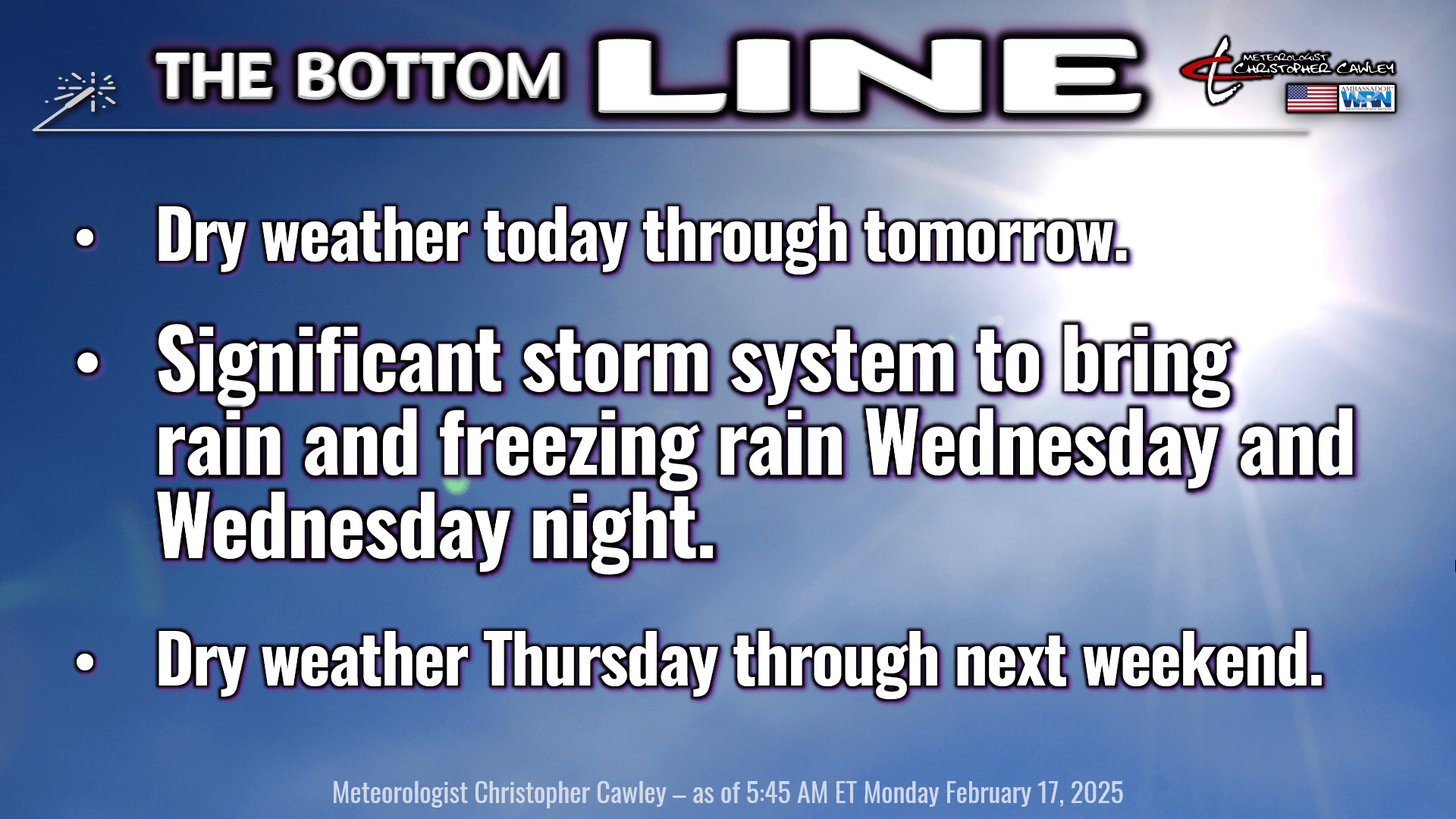
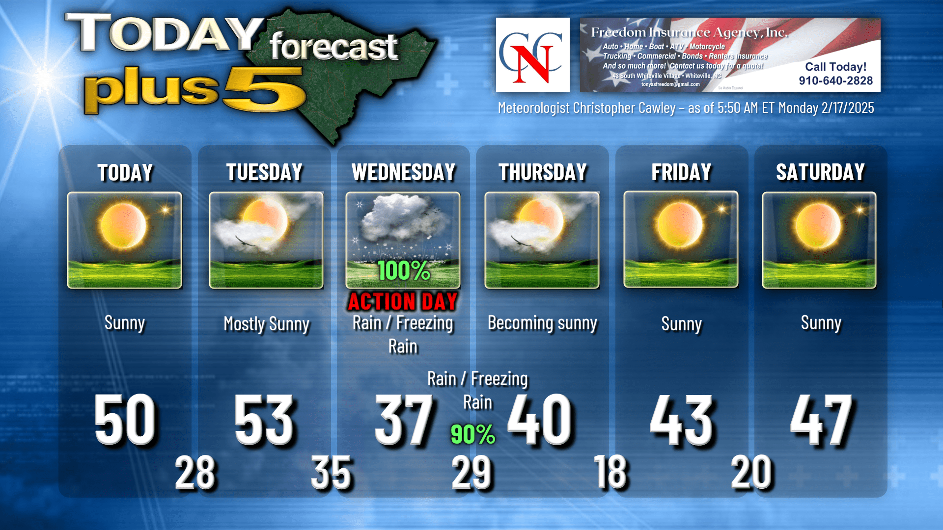
We’ll have an abundance of sunshine today and Tuesday as high pressure is in firm control. Cold temperatures tonight, lows dropping into the upper 20s across the area. Kids at the bus stop tomorrow morning should be prepared for temperatures in the upper 20s with light winds.
The focus of the weather this week is the significant storm system that will impact our area Wednesday and Wednesday night.
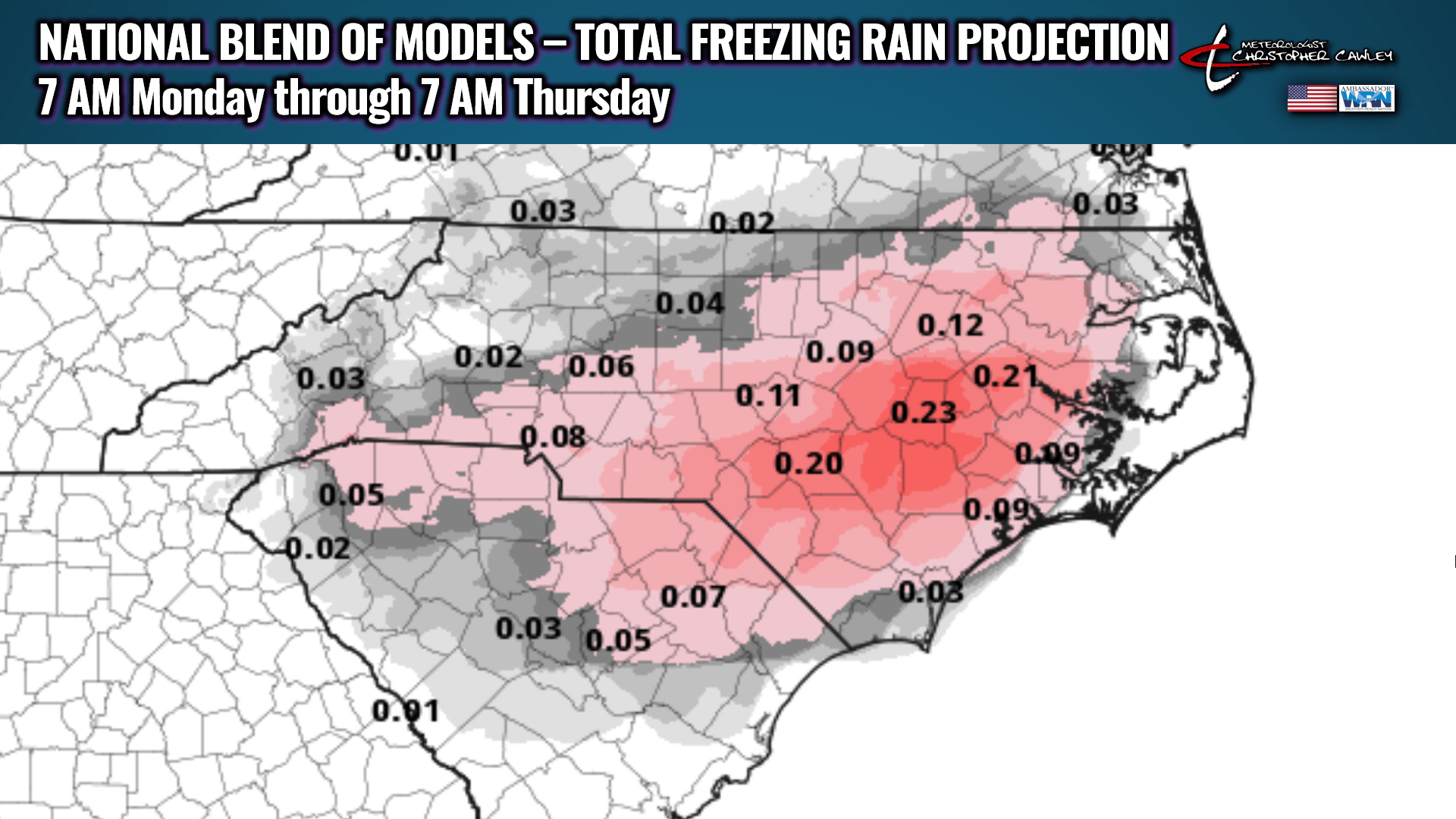
The latest model runs have me quite concerned for the potential for freezing rain across Columbus County, especially the western half of the county. As of this writing, NWS isn’t on board with this but, quite frankly, I don’t agree with their assessments at this time.
Low pressure develops on the southern branch of the jet stream later Tuesday afternoon into Tuesday evening. At the same time, a shortwave trough (a disturbance in the atmosphere) dives southward out of Canada flooding cold air across the eastern US.
The low pressure crosses northern Florida, turns the corner and heads northeast along or just off the coast. Here we go, game on.
The GFS and European models diverge on the track of the low, with the GFS much farther offshore, while the latest Euro deterministic keeping the low closer to the coastline. Today’s Euro plots are a little farther south/east with the storm track than they were yesterday, which would imply some colder air in place. However, the low is still close enough to the coast that plenty of “warm” (relatively) air pushes in the middle and upper levels of the atmosphere, “over the top” of the cold air trapped at the surface. This sets the stage for a freezing rain event.
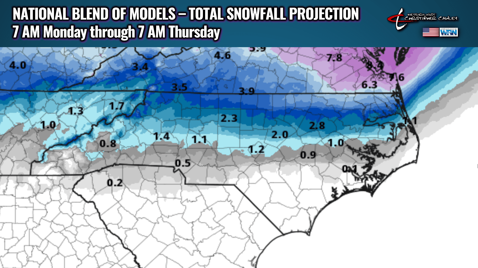
I am highly confident that we will not receive any accumulating snow from this event.
My forecast is going to lean more heavily on the European model solution. Clouds increase Tuesday night. Our lows drop to the mid 30s by early Wednesday morning. Rain develops by mid-morning Wednesday. Temps rise to the upper 30s before the onset of rain, but the falling rain results in a cooling effect of the atmosphere. Therefore, temperatures slowly fall during the afternoon.
Here’s where the details get very sketchy.
If surface temperatures (up to about 100 feet) run at or below 32 degrees, the liquid raindrops falling from the cloud become supercooled and freeze on contact with any surface. That’s freezing rain. WILL the temperatures drop to 32 or below on Wednesday afternoon? I can’t answer that. It’s definitely possible.
A couple of degrees will be the difference between an ice storm and a cold rain on Wednesday.
Rain continues into Wednesday night, and I believe that we will have a transition to freezing rain during the evening. How much ice accumulation will depend on how quickly the low pressure center moves off to the north and east. I believe there will be some icing that occurs… and that will make travel conditions late Wednesday night and Thursday quite miserable.
The precipitation should taper off around or shortly after midnight… and actually may transition to a very brief period of snow at the end. No snow will accumulate. Temperatures drop to the upper 20s by early Thursday morning, and anything that’s wet will freeze. The Thursday morning commute could end up being a nightmare, especially on secondary roads.
If you’re traveling toward Lumberton or Elizabethtown, and points west and north, a much higher likelihood of a true-blue ice storm exists.
Attached here are the National Blend of Models snowfall projection and freezing rain projection through 7 AM Thursday. These are updated hourly; if there are any significant changes, I will post them on my socials and on the CCN Facebook page.
If the GFS ends up being the winner, we’ll have some periods of mainly light rain or light freezing rain Wednesday afternoon and evening, tapering off before midnight. There will still likely be some light ice accumulations but the overall magnitude of the storm, in the opinion of the GFS, is much less.
I’m going ahead and posting “Action Day” for Wednesday into Wednesday night. “Prepare for the worst, hope for the best, and expect something in between.” Worst case scenario is an ice storm. Best case scenario is just cold rain from beginning to end.
Dry Arctic high pressure builds in after the storm departs. Temperatures Thursday night into early Friday morning drop to the upper teens across the area. We’ll have a SLOW, and I do mean SLOW, warming trend as we progress through the weekend… but then temperatures rise well above seasonal normal values NEXT week (the week of the 24th).
Here’s your Freedom Insurance Today-Plus-5 forecast for Columbus County.
That’ll do it for today. Thanks for reading, and as always, take care!
~Meteorologist Christopher Cawley