Hello everyone, welcome to the CCN Weather Update for Saturday February 15, 2025.
This is a long report today.
Your CCN Weather Update is sponsored by Freedom Insurance in Whiteville. Call 910-640-2828 or visit their office, and their experts will provide you with the peace of mind you need for whatever you need covered. From life to vehicle to homeowner, Freedom Insurance has your back.
STATISTICS FOR WHITEVILLE – Friday February 14, 2025.
High: 57.1°F at 2:37 PM (normal is 58)
Low: 37.1°F at 7:34 AM (normal is 33)
Precip: 0.00 in
View live, real-time weather data for Whiteville on my College Street Weather Station.
Here’s your Bottom Line for today…
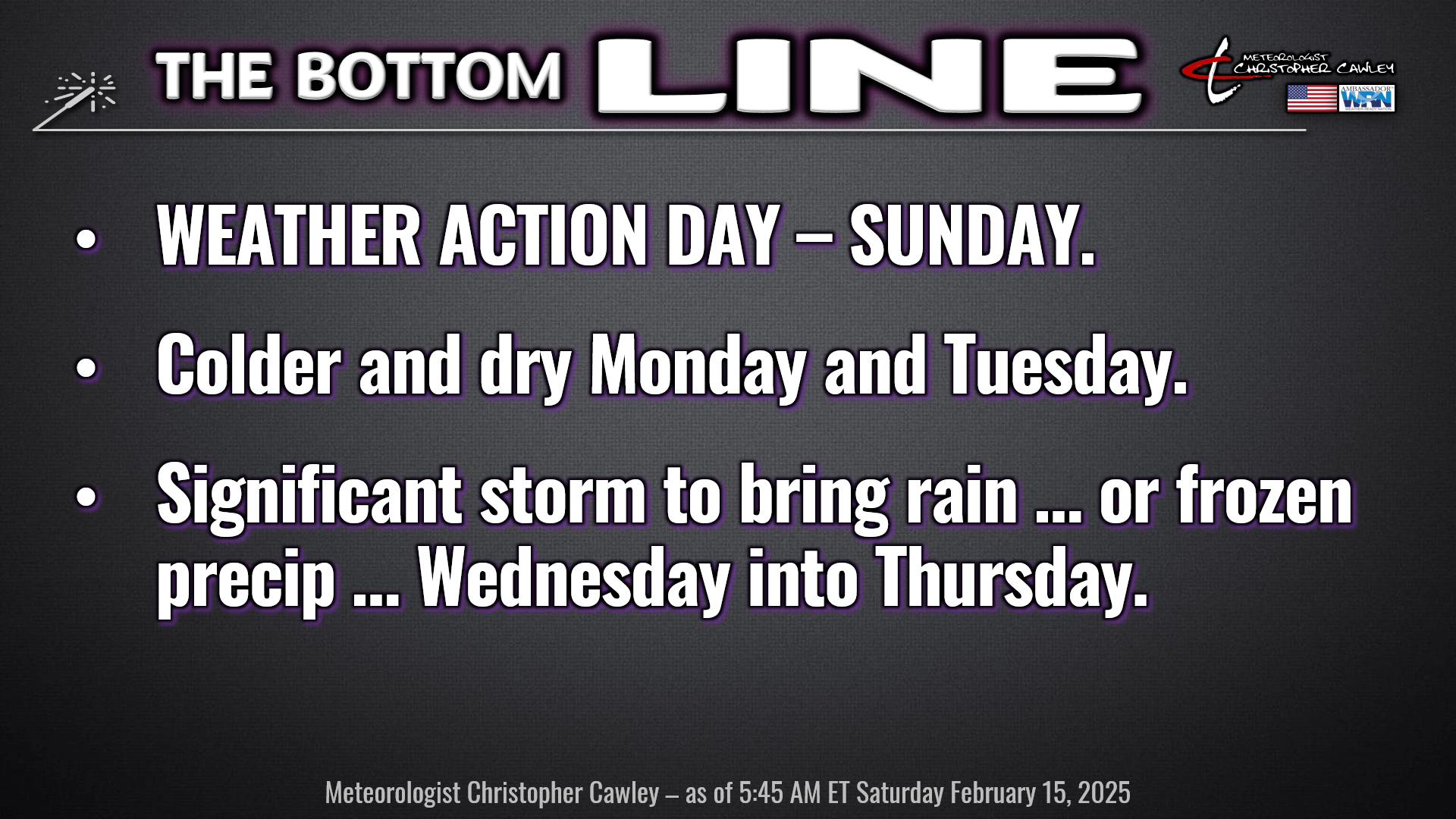
Okie doke, friends, two big things to talk about today. A cold front with a bad attitude moving through Sunday afternoon with stormy conditions ahead of it, and the significant storm system for next week.
TODAY: A coastal frontal boundary (a trough) will push inland, raising our temperatures and moisture levels as winds switch from a northeasterly flow to a southeasterly flow behind the trough. I believe our temps will jump well into the 60s, but it may be later this afternoon before that happens. If the front doesn’t successfully push across the county, we’ll be stuck in the upper 50s with lots of clouds. Light shower activity begins to develop later this afternoon, but I think the showers will be spotty in nature.
TONIGHT: Warm front lifts north across the state and we are firmly in the warm sector. Deep moisture in place will lead to better chances for showers to develop… some of the rain may be briefly on the heavy side. But the key word is SHOWERS.
SUNDAY: “Weather Action Day.” Strengthening low pressure in the Ohio Valley in the morning will drag a strong cold front across the area later in the afternoon as the low moves through my old stomping grounds of far upstate New York. Well ahead of the front, a line of rather energetic convective precipitation is a near-certainty. I don’t think there’ll be much lightning with this thanks to limited instability… but a strong low-level jet (60-70 knots, or 70-80 mph) will make for gusty winds at the surface, especially with the convective line.
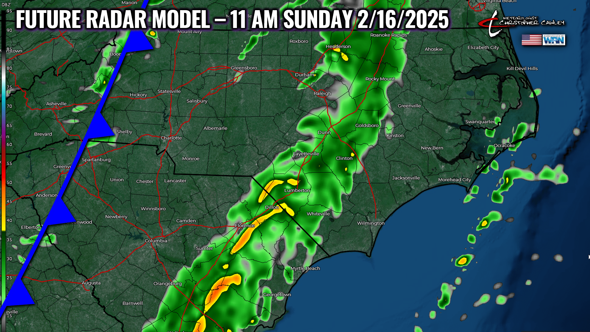
The line moves through around or shortly after lunchtime. Again, a burst of moderate to heavy rain, some gusty winds, and in about an hour it’s a memory. We may break out with some sunshine later in the afternoon which, in an odd turn of events, may increase atmospheric instability just ahead of the actual cold front. So it may actually become MORE windy during the afternoon AFTER the squall line moves through.
SUNDAY NIGHT INTO MONDAY AND TUESDAY: Cold front clears the coast after suppertime on Sunday, with cold, dry air whooshing in behind it. Our skies rapidly clear Sunday evening, and by Monday morning, our temps are in the 30-33 degree range. Highs on Monday will struggle to reach the 50-degree mark. Slightly warmer on Tuesday with continued dry weather.
SIGNIFICANT STORM SYSTEM LIKELY WEDNESDAY-THURSDAY.
An area of low pressure is likely to develop in either the northern Gulf or just off the FL/GA coast by Wednesday morning. Guidance depicts this system lifting northeast along the coast into Wednesday night / early Thursday.
With a dry, cold air mass in place ahead of the system, and a reasonably favorable low track, the deterministic models AND their respective ensemble members continue to show the POTENTIAL for frozen precipitation in the Carolinas, particularly Wednesday night.
Below are the latest deterministic model plots for 10 PM Wednesday evening. Please note, these are going to change, possibly quite a bit, between now and then, but I wanted to share EXCLUSIVELY with the CCN readers, a few pictures of what we’re facing.
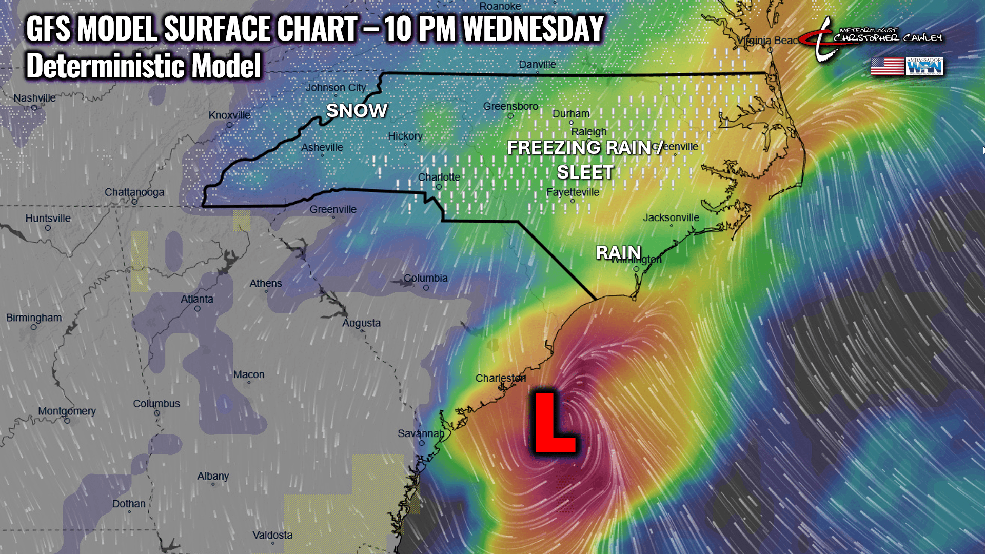
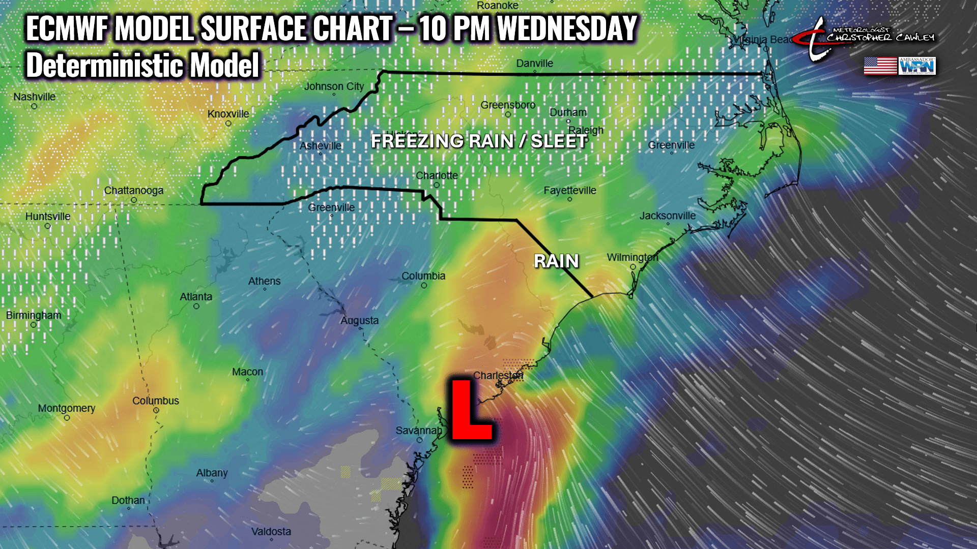
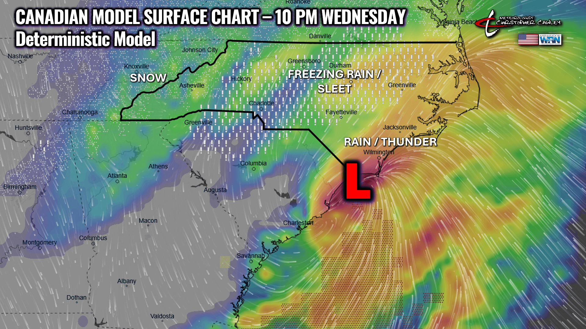
So as you can see, we have three different global deterministic plots with three different results. Forecasting “who gets what” at this point is an impossible task.
What we ultimately get will depend on the degree of phasing (merging) that can occur between the southern stream wave and a disturbance on the northern jet diving down from the Great Lakes, (which the Euro has more of compared to the GFS) combined with the ultimate track of the coastal low.
IF we get any frozen precip from this, I believe it will be freezing rain. Of the ensemble members, 11 out of 82 are showing accumulating snowfall. Unless that low slips a little farther offshore, or we get a sudden, unexpected push of much colder air, we’re not going to see snow from this here. It’s going to be either cold rain or freezing rain on Wednesday night.
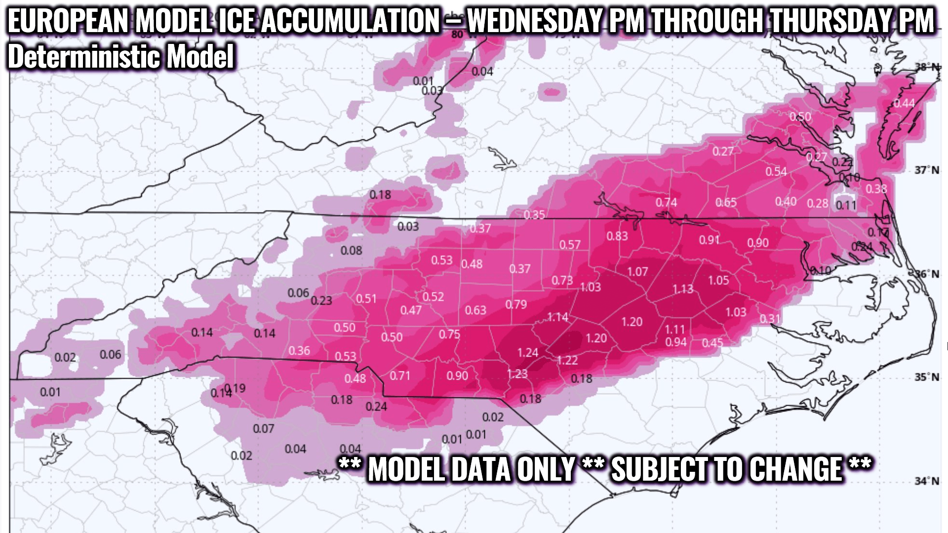
No matter what happens, this is going to be a juicy/spicy storm system with lots and lots of moisture. NBM suggests well over an inch of rain / liquid equivalent in this event.
The European deterministic is showing what would be a life-threatening ice storm across central NC. I pray this doesn’t materialize — amounts such as 1.22″ ice accumulation for Fayetteville/Ft. Bragg, 1.20″ for Raleigh, 1.20″ for Smithfield, etc., etc. Yes, that’s an inch-and-a-quarter of solid ice. The southern extent of the ice accumulation shown by this model runs from Lumberton through Clinton. I *pray* this doesn’t verify. Post-Helene PTSD is a very real thing in North Carolina. The last thing anybody needs is a crippling ice storm shutting utilities down.
Here’s the graphic, for those interested. Again, this is likely to change.
For now, I’m going to keep it simple with my extended forecast and go for rain developing Wednesday afternoon, and then “rain or freezing rain” Wednesday night, ending as rain on Thursday. As I’ve said now for 3 days, “watchful waiting.”
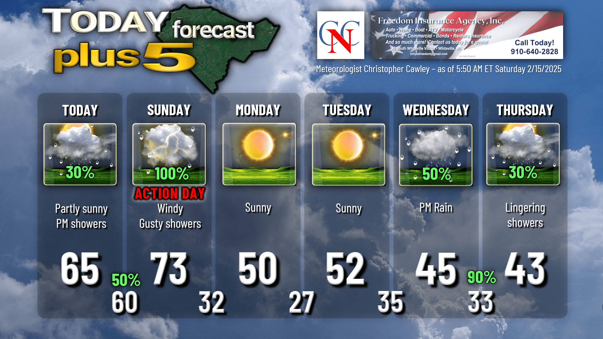
Here’s your Freedom Insurance Today-Plus-5 forecast for Columbus County.
And with that, we come to the conclusion of another CCN Weather Update. I want to give a sincere thanks for reading and sharing. I realize there’s a lot here, in a very active weather pattern. If you ever have any weather-related or forecast-related questions, don’t hesitate to reach out to me on my socials. I hope you have a wonderful day, and as always, take care.
~Meteorologist Christopher Cawley