Hey folks, welcome to the Wednesday edition of the CCN Weather Update!
Sponsoring the CCN Daily Weather Update is Freedom Insurance of Whiteville, NC. Freedom Insurance believes in providing peace of mind for you and your loved ones. Whether you’re looking to safeguard your home, car, health, or business, Freedom can offer tailored insurance solutions to meet your unique needs. Contact them today at 910-640-2828 or stop in at their office across from Lowe’s in Whiteville.
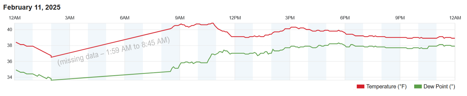
STATISTICS FOR WHITEVILLE – Tuesday February 11, 2025.
High: 40.8°F at 10:45 AM (normal is 57)
Low: -missing data- (normal is 33)
Precip: 0.02 in
View live, real-time weather data for Whiteville on my College Street Weather Station.
We had “steady” temperatures essentially all afternoon and evening. Here’s the tracing from my weather station for yesterday. (Note, there was a data error of unknown origin that resulted in some missing data.)
Here’s your Bottom Line for today…
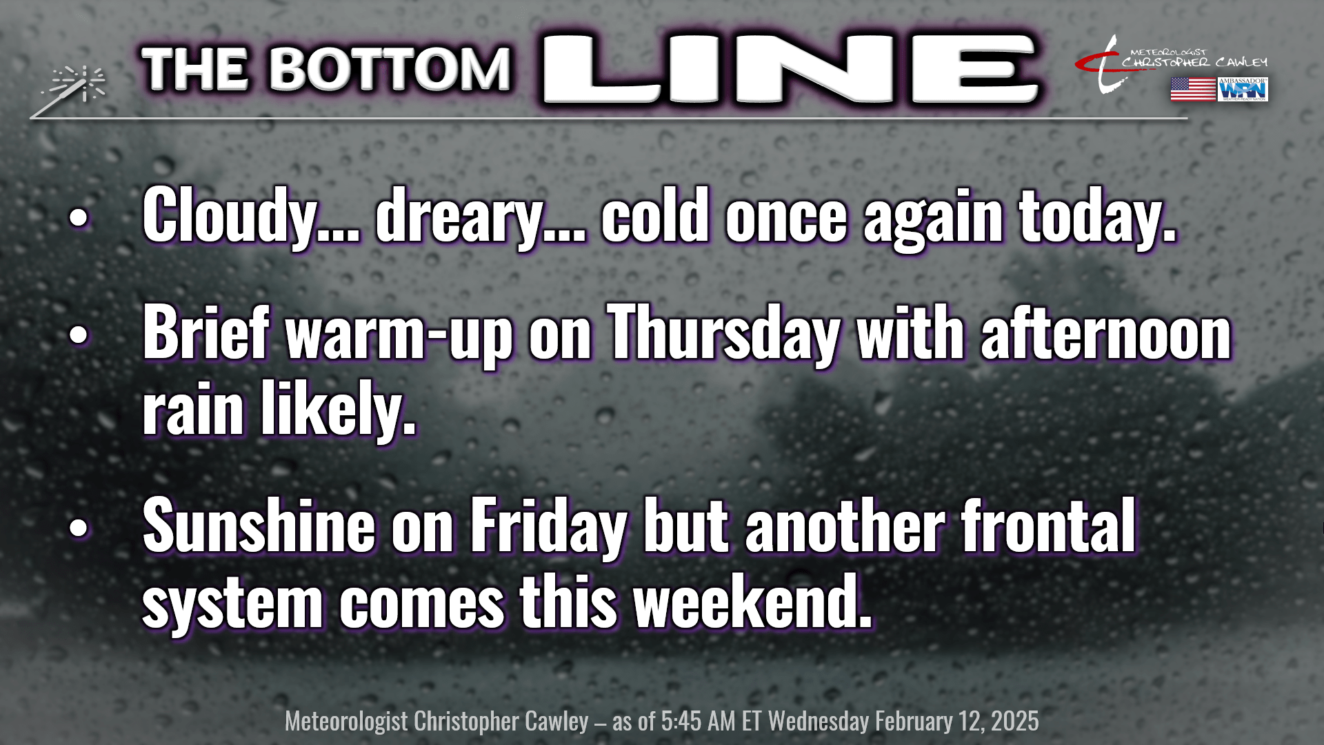
Roses are red
Violets are blue
I’ve got more clouds
and rain for you.
Well, on yesterday’s blog I said it was a low-confidence temperature forecast, but I didn’t think it would be as cold as it was. The cold-air-damming, otherwise known as a “wedge,” really dug its heels in place, leading to the cloudy, COLD, and misty conditions through the day.
I honestly don’t have a whole lot more confidence for today’s temperatures. The wedge remains in place, and the high-res short-term modeling suggests that we’ll be solidly in the 40s today. Given the strength of the wedge in place, I don’t really see a reason to go against that grain.

As for precipitation, the best forcing and lift remain farther to our north and west, so the bulk of any rainfall will be west of the I-95 corridor. Low-level saturation will maintain some patchy light rain across the county, mainly this morning. This will be so “low” to the surface that the radar beam shoots completely over the top of it, so little if anything shows up on radar. Anyway, the guidance suggests a little bit of drier air starts to push in at the middle levels of the atmosphere after lunchtime, so I think that puts an end to any spotty light rain/drizzle that we might be experiencing. Skies remain cloudy and temperatures remain cold, about 10-12 degrees below normal, through the afternoon.
A warm front will begin to lift north. I swear it will. I *promise* it will. It’s just in no real hurry, enjoying the hospitality of our friends in Georgia and South Carolina, but eventually it will get with the program and start to lift north into this evening.
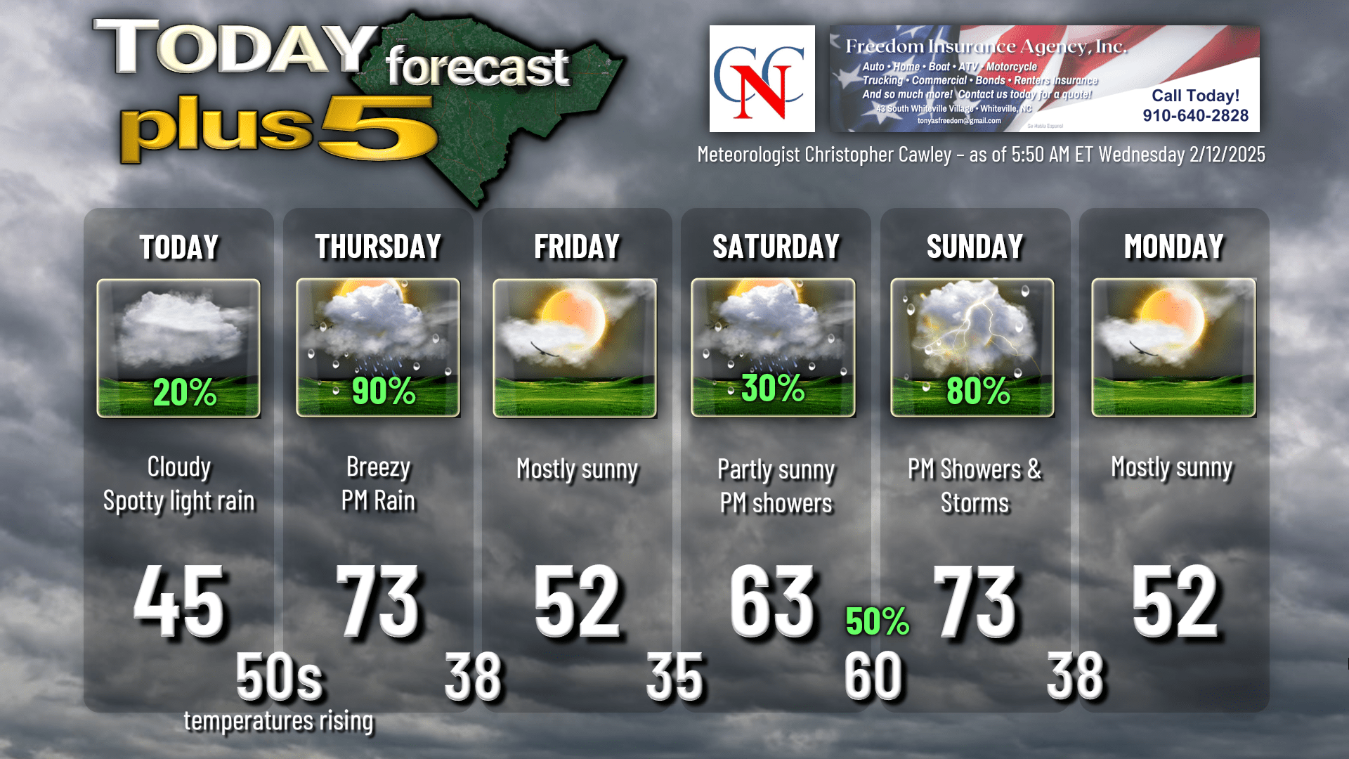
This front – FINALLY – pushes north over the area tonight, and our temperatures rise like a phoenix through the night. A STRONG push of warm air comes in for a little while as the warm front pulverizes the wedge and lifts north of the area Thursday morning. Highs Thursday will likely reach the lower 70s. Maybe mid 70s if we can get some breaks of sunshine.
Meanwhile a strong cold front begins to approach from the west as a deep area of low pressure heads toward the Great Lakes. This cold front should push through the county sometime Thursday afternoon. The timing is a bit sketchy but … it should be before suppertime Thursday. Rather windy conditions set up ahead of the front, and if we can get some sunshine to poke through, that adds to the instability and therefore an uptick in our winds.
Also with the front comes a band of true RAIN to the area. It appears there will be good shear in place, so if we can get those instability numbers to bump up a bit, some thunder could accompany the front as well. A relatively quick hit with the band of rain, but the band could put down up to about half an inch of rainfall.
A cool, DRY air mass pushes in behind the front Thursday night. The clouds push out stage right and temps drop into the 30s… but should stay above freezing.
Another wedge/cold-air-damming regime sets up for Friday. This won’t be nearly as strong, and there won’t be nearly the moisture in place. So I expect a good deal of SUNSHINE (!) on Friday, but our highs will be stuck in the lower 50s.
Saturday’s forecast becomes a bit of a challenge as we face down the question of how fast will the wedge break down as a warm front starts knocking on our door. How far north does the front actually make it? Will the wedge try to flex some muscle and hold on longer? These questions result in a low-confidence temperature forecast once again. I’m going to go on the cooler side of MOS guidance and go with lower 60s for now. This is another case where we could stay stuck in the lower 50s, or we reach the lower 70s. Shower chances return Saturday afternoon in advance of that warm front.
Showers are likely Saturday night with the warm front passage, and our temps once again hold steady, if not rise a little bit.
Wash, rinse, and repeat Thursday’s scenario on Sunday. We’re in the warm sector, it gets rather breezy ahead of a strong cold front, and another round of robust rainfall and possible thunder moves through Sunday afternoon. Too soon to really know if we’ll have any severe chances Sunday afternoon… that’ll depend on the timing of the frontal passage.
Cool, dry high pressure moves in for early next week with below-normal temperatures. Deterministic modeling is still in agreement on a potential significant east-coast storm later next week. The latest GFS is pointing to heavy ice/snow in our area, but this is going to change about thirty-seven times between now and next week. Euro also has a colder solution than yesterday, with ice dangerously close to the area. We’re in the “7 to 10” day range at this point, so we’re in the “watchful waiting” phase.
Here’s your Freedom Insurance Today-Plus-5 forecast for Columbus County.
That wraps up today’s report… thank you for reading! Try to stay warm and dry today, and make it a great day. As always, take care.
~Meteorologist Christopher Cawley