CCN Weather Update for Friday June 6, 2025.
This weather update is sponsored by Freedom Insurance of Whiteville. When severe weather strikes, with Freedom Insurance you will always be prepared. For home, car, boat, or whatever you need, Freedom can provide customized coverage to keep you and your family safe. Contact Freedom today at 910-640-2828!
Here’s today’s Bottom Line
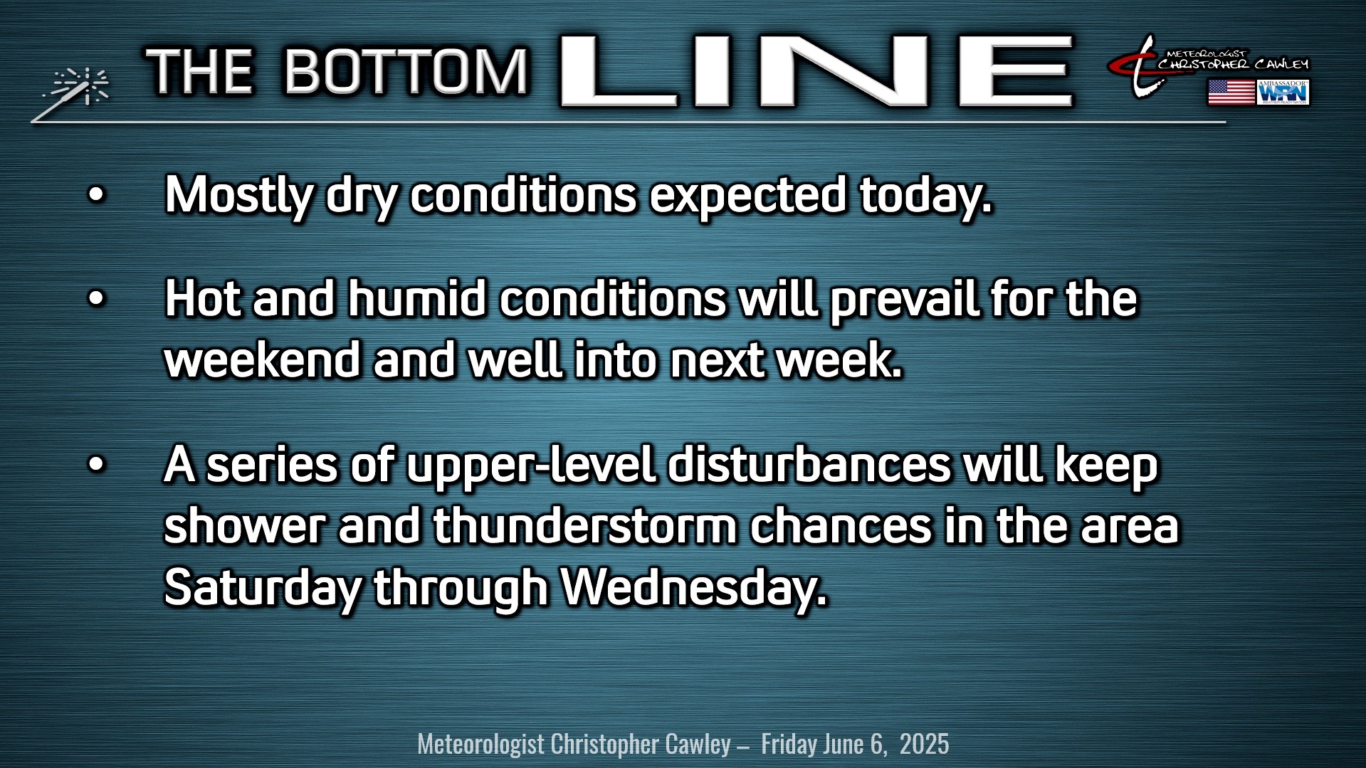
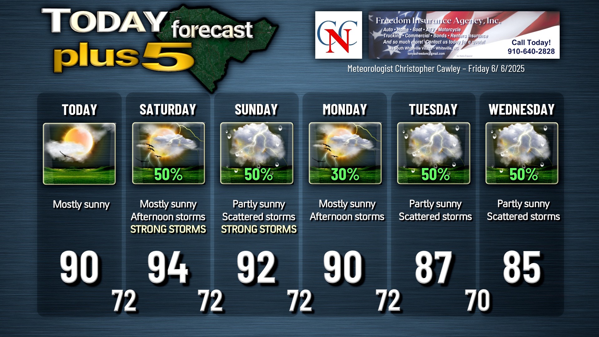
Today will likely be the only dry day for the foreseeable future. We should see a mix of sunshine and clouds for today with highs around 90. There is the slightest chance for a thunderstorm to pop along the sea-breeze boundary that pushes from east-to-west later this afternoon.
Our weekend will be hot and humid. Dewpoints rising into the 70s, combined with actual temperatures in the lower to middle 90s on Saturday, will lead to heat index values a degree or two either side of 100°F during the afternoon. (Heat index represents a mathematical combination of air temperature and dewpoint, which is a measure of relative humidity. Heat index represents what it “feels like,” and is similar to wind chill during the wintertime. Heat index of 100°F is just below the official Heat Advisory criteria established by the National Weather Service (heat index values of 105°F – 109°F for 2 hours or more).
Saturday will be mostly sunny for much of the day, but a looming severe weather threat exists in the afternoon through the evening. There will be dramatic atmospheric instability, and modeling shows significant CAPE (Convective Available Potential Energy) values for this area. There is agreement with some of the modeling of a squall line of strong to severe thunderstorms marching across the state on Saturday, arriving in our area in the late afternoon or early evening. Other models have massive drying in the middle and upper levels and therefore show nothing in the way of thunderstorm activity, even with the high instability in place. It really is 50/50. It may be that we get nothing at all, but I think for outdoor activity planning, it’s good to be prepared for the potential for thunderstorms. Severe weather parameters for Saturday, if we get any, point toward “wet downbursts,” which are strong to violent downdrafts of air within a thunderstorm accompanied by blinding rainfall. These downdrafts can produce damage similar to that of tornadoes, and can be mistaken for tornadoes in some circumstances, even by the most experienced and/or knowledgeable spotters. (Recent downbursts/downdrafts/microbursts in Horry County from May 30th had estimated wind speeds of 90-95 mph, per NWS Wilmington.)
Sunday features more heat, but with slightly cooler actual high temps thanks to more in the way of cloud cover and a better thunderstorm chance. Shear and instability profiles look quite excellent if you’re a fan of severe weather. The Skew-T profiles point to the potential for additional wet downbursts with thunderstorms that develop on Sunday. Large hail is also quite probable on Sunday.
As for temps on Sunday, again, we’ll be cooler with regards to actual high temps, but heat index values will once again be around 100°F, just below criteria threshold.
The remainder of the forecast period, Monday through Wednesday, continues with unsettled weather conditions. Several middle-level disturbances are expected to push through the area while we remain laden with deep tropical moisture. That sets the stage for repeated thunderstorm threats through the period, along with sunshine. Monday should be the “driest” day with increased storm coverage for Tuesday and Wednesday. Some of these storms could produce significant / flooding rainfall. Slightly cooler temps Tuesday and Wednesday but heat index values will still be deep into the 90s.
TROPICAL OUTLOOK: No tropical system development is expected over the next 7 days. Much of the Atlantic remains under the influence of ridging high pressure. The Sahara dust layer also continues to flow over the tropical Atlantic. Typical shower-and-thunderstorm activity over the Gulf remains largely unorganized.
Here is your Freedom Insurance Today-plus-Five Forecast:
–Meteorologist Christopher Cawley