CCN Weather Update for Monday June 16, 2025.
This weather update is sponsored by Freedom Insurance of Whiteville. When severe weather strikes, with Freedom Insurance you will always be prepared. For home, car, boat, or whatever you need, Freedom can provide customized coverage to keep you and your family safe. Contact Freedom today at 910-640-2828!
Here’s today’s Bottom Line
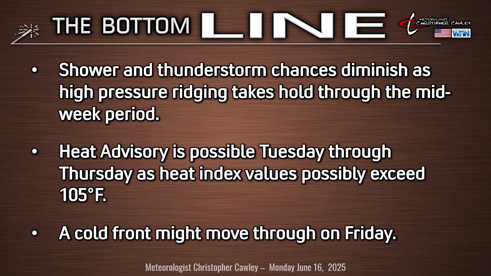
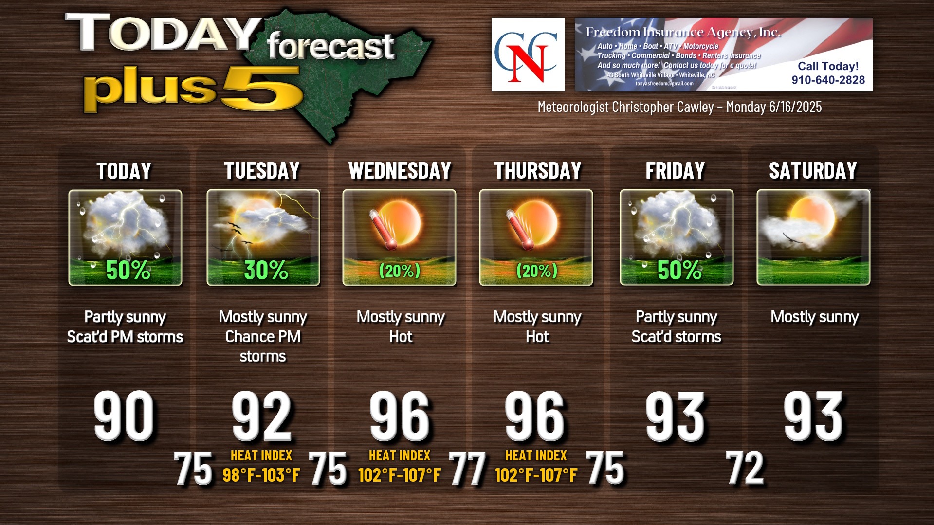
- Sunshine and storms today.
- Sunshine and HEAT (and maybe a few storms) Tuesday through Thursday.
More thunderstorm activity is expected this afternoon in the juicy, unstable environment. This is a southerly flow around the western edge of a massive Bermuda high pressure ridge. At the surface, a diffuse stationary front over northern North Carolina will slowly lift northward.
Locally, the best chances for thunderstorms today will be the same as we’ve had the past several days, mainly in the afternoon through the mid-evening hours. Impossible to tell who will and who won’t get storms, and any storm that develops could produce intense rainfall, frequent lightning, and possible strong wind gusts.
Thunderstorms are expected once again on Tuesday but I think there will be less overall coverage as the high pressure ridge starts to shift westward setting the stage for HEAT.
We’re roasting hot Wednesday and Thursday as the western edge of that high pressure ridge becomes established over the county. I’m expecting highs in the mid to upper 90s with heat index values 102-107. Some isolated backyard thermometers or car dash displays may show 100 degrees on Thursday.
A weak cold front will push into that high pressure ridge on Friday, breaking it down enough to bring scattered to numerous showers and storms. Temperatures “cool” to the lower 90s for Friday and Saturday. The cooldown doesn’t last long, as modeling shows temps jumping back into the mid and upper 90s Sunday going into NEXT week.
HEAT.
Let’s talk a little bit about heat, since we’re going to experience lots of it this week.
Heat is something that we deal with in Columbus County every summer. But people new to the area may not realize just how hot it can get. It sure ain’t a dry heat!
I used to tell my family up north, “you don’t know what ‘hot’ is until you stand in my driveway at 3 PM on a June or July afternoon. Then you’ll know what ‘hot’ really is.”
Wednesday and Thursday will likely be the hottest days so far this season, with actual highs in the middle to upper 90s, with heat index values pushing 105°F or higher during the afternoon. We reached 97.0°F on my weather station on the 5th, so I think we’re going to experience that level once again.
Even higher heat index values will be noted in urban centers, in “downtown” areas.
What is heat index? Heat index represents a mathematical combination of air temperature and dewpoint (a measure of relative humidity). Heat index represents what it “feels like,” and is similar to wind chill during the wintertime.
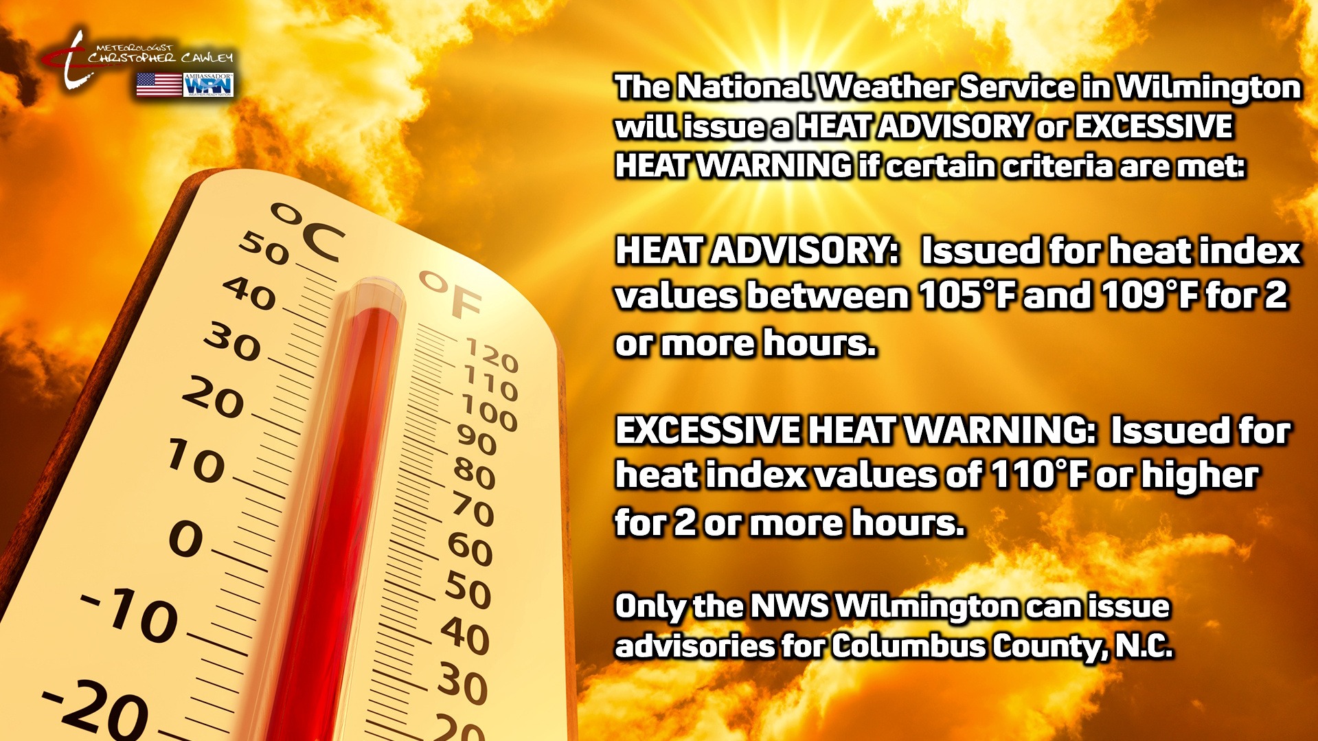
When conditions warrant, the National Weather Service in Wilmington, NC, will issue either a HEAT ADVISORY or an EXCESSIVE HEAT WARNING for Columbus County.
A HEAT ADVISORY is issued when heat index values are between 105°F and 109°F for 2 or more hours.
An EXCESSIVE HEAT WARNING is issued when heat index values are 110°F or higher for 2 or more hours.
(The heat index values utilized by the NWS are recorded at area airports. These values will be a little bit lower than what is experienced in cities and towns, where people actually live.)
It should be noted that these advisories are different than the “heat and health advisories” that are being issued by state health department officials — those are not NWS advisories, nor will they be referenced in my blogs.
When the heat index reaches ADVISORY criteria, heat exhaustion symptoms can develop in very short order when exposed to such conditions.
When the heat index reaches WARNING criteria, heat stroke symptoms can develop in very short order.
Heat stroke symptoms constitute a true medical emergency, just like a heart attack or stroke. For a person exhibiting heat stroke symptoms, the first course of action should be to call 911.
That being said, people can experience heat exhaustion/stroke symptoms with lower heat index values of 95°F or higher.
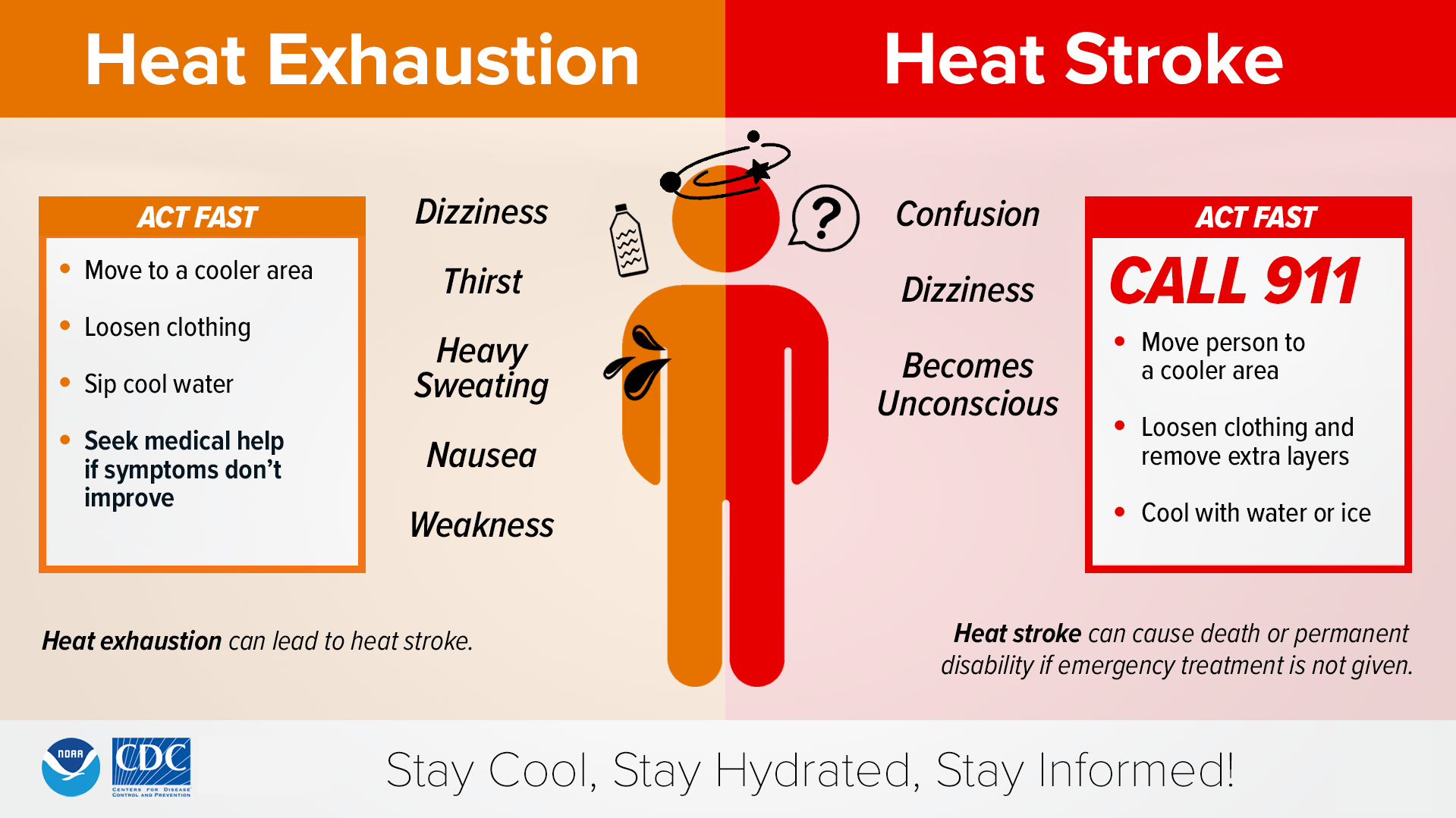
If you must be outdoors during hotter weather periods, make sure you take plenty of breaks, wear lightweight, light-colored, loose-fitting clothing, and drink plenty of water or electrolyte-replacing drinks similar to Gatorade. Avoid alcoholic beverages and sodas.
Heat is one of the top weather-related killers, and doesn’t discriminate. People of any age, any physical condition, any race are subject to heat-related illnesses.
If you have outdoor plans this week, make sure you have plenty of water available, and listen to your body. If you start to feel unwell, there’s no shame in saying, “it’s too hot” and taking a step indoors.
TROPICAL OUTLOOK: Other than a cold front extending from the NC/VA state line east/northeast to a low-pressure center spinning just south of Greenland and Iceland, there’s nothing doing in the Atlantic Ocean. No tropical cyclone activity is expected in the next 7 days.
Here is your Freedom Insurance Today-plus-Five Forecast:
–Meteorologist Christopher Cawley