Good evening, Meteorologist Christopher Cawley here with the update for Sunday October 27, 2024.
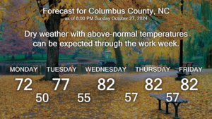
Some areas across the county picked up a little bit of much-needed rainfall on Sunday… a little bit is better than nothing. That’s it though… because we’re going to close out the month of October with more dry weather and above normal temps.
High pressure is going to reassert control and become firmly entrenched over the mid-Atlantic states this week. This will allow for an eventual southwesterly air flow and a return to temps at or above 80 for the midweek period. A cold front will approach by next weekend, but modeling suggests that it washes out and brings nothing more than some cloudiness to the area, if even that.
Monday will feature highs in the lower 70s… but we’ll quickly rise to the lower 80s through Halloween and Friday as well. Slightly cooler temps are expected by next weekend.
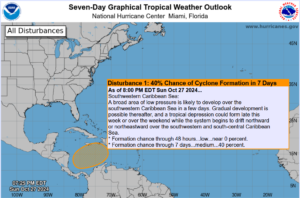
Looking at the tropics, I mentioned last week that there would be the potential for some kind of development in the Caribbean Sea, and the NHC has connected on this, pegging it with a 40% probability of becoming a tropical system within the next 7 days. No matter what happens with this, there is no threat to the continental United States at this time.
As we go into November, the probability of tropical systems impacting the US drops off quite rapidly, and the season ends on November 30th.
That’ll do it for tonight’s update. Thanks for reading, and take care!


