Good evening! Meteorologist Christopher Cawley here with your weather update for Wednesday November 6, 2024.
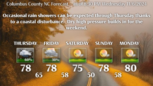
Rain chances are in our forecast later tonight through Thursday as a surface disturbance moves inland. The best rain chances occur early Thursday as the best dynamics will be in place at that time. I wouldn’t be surprised to hear a rumble of thunder as models show some atmospheric instability in place.
Shower chances continue Thursday night as a southwesterly flow remains in place ahead of a cold front. This front will move through during Friday bringing an end to the rain chances, with drier and less humid conditions expected on Saturday.
Temperatures will remain unseasonably warm in the tropical airmass ahead of the cold front. After the front, temps will still be quite a bit above normal but humidity levels will drop back down.
Rainfall amounts for the county should be between one-half and one inch by the time things wrap up late Thursday night or early Friday. Not an awful lot, but every little bit will help.

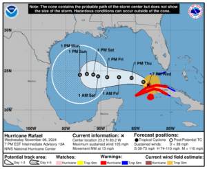
Tropics: MAJOR changes to the expected storm track with Hurricane Rafael. Rafael is expected to continue to move around the southwestern side of a mid-level ridge over the southwestern Atlantic during the next day or so. After that time, the ridge is forecast to build westward over the eastern Gulf of Mexico which should cause Rafael to turn more westward over the southern Gulf of Mexico. By Friday, the spread in the track guidance increases once again, with the GFS showing a more northward solution than most of the remainder of the track guidance. The NHC track forecast has been shifted significantly southward to be in better agreement with the various model runs. I wouldn’t be surprised to see a shift even farther south or southwest, or a shift back to the north just a bit, as further modeling comes in. I think the chances for a hit along the Gulf coast is low, but I’ll keep watching.
That’s it for tonight yall. Thanks for reading and take care!


