Good morning friends and neighbors, Meteorologist Christopher Cawley here with your exclusive CCN weather update for Saturday December 21, 2024.
It’s the first day of winter, the winter solstice having occurred at 4:21 this morning. It’s the shortest day of the year (shortest by daylight, that is), with the sunrise at 7:17 AM and the sunset at 5:09 PM.
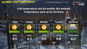
It’s sure going to feel like winter, especially Sunday and Sunday night thanks to strong Arctic high pressure firmly in place. I’ve gone up just a tick on our temperatures based on the latest series of modeling showing this air mass modifying just a touch. It’s still going to be cold.
The high pressure ridge starts to push into the Atlantic on Monday, which allows a bit of a wind shift and slightly warmer temps. We’ll return to what would be considered seasonal norms on Christmas Eve, with highs into the upper 50s.
A disturbance on the southern branch of the jet stream starts to take aim on the area for Christmas Day. The majority of the energy with this system goes off to the north, and the axis of the system itself looks to move more north than east. Therefore a moist, southerly flow becomes established leading to more clouds than sunshine for Christmas Day into the weekend, along with intermittent rain chances.
That concludes today’s report… short and sweet. I hope everyone has a fantastic weekend, and as always, take care!


