Greetings readers, welcome to the CCN Weather Update for Sunday January 12, 2025.
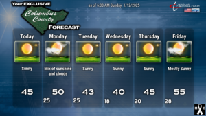
One of the longest stretches of unusually cold weather in recent memory will continue through… probably the end of January. We may have a few scattered “milder” days (by comparison), but on the whole the trend is below normal in terms of temperatures.
There’s not much to talk about in terms of weather systems for the next several days. A dry cold front moves through the area late Monday. The front itself will bring some cloudiness… and a renewed push of Arctic high pressure behind it. Our temps are going to run some 15+ degrees below normal during the middle- to late-week period.
The NWS continues to hint at the possibility of a “Cold Weather Advisory” Tuesday night/Wednesday morning. It’ll be close… the criteria is a temperature of 5°F to 15°F, and I’m going with 18°F for the morning low.
Our next weather system is expected to arrive next weekend. While it’s a bit far out in time to pinpoint the details, the guidance suggests a rapid push of “warm” temperatures (again, relatively speaking). A cold front crosses the area late Saturday, and as it clears the coast, there is some hint in the guidance that a coastal storm may come together. If it does, the question will be, how quickly does it exit before the cold air pushes into place behind the front. Again, way too far out in time to hammer down any details. Arctic cold weather is likely to return thereafter for the week beginning January 20th.
That’ll do it for today’s post. Thank you for reading (and sharing), and as always, take care!
–Meteorologist Christopher Cawley


