Hello friends, welcome to the Monday edition of the CCN Daily Weather Update!
This weather update is brought to you exclusively by Freedom Insurance of Whiteville. There is never a better time than the present to make sure all of your policies are up to date and all coverage is in place. Give Freedom a call today and they can take a look at everything and make sure it’s all top-tier. Call 910-640-2828 today and speak to the friendly representatives at Freedom Insurance.
Sunday 2/2/2025 at Whiteville–
High: 53.8°F at 2:50 PM
Low: 41.7°F at 7:06 AM
Precip: 0.02 in
View live, real-time weather data for Whiteville on my College Street Weather Station.
Here’s your Bottom Line for today…
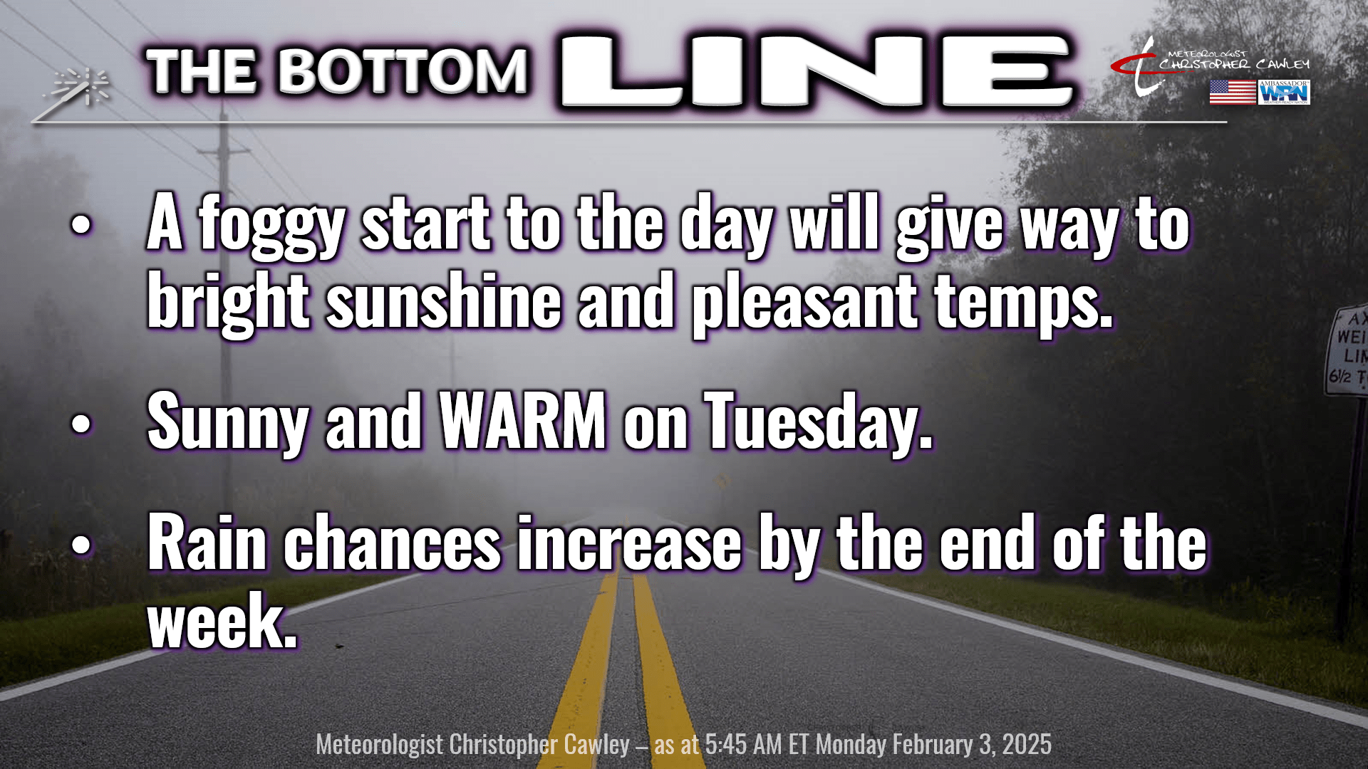
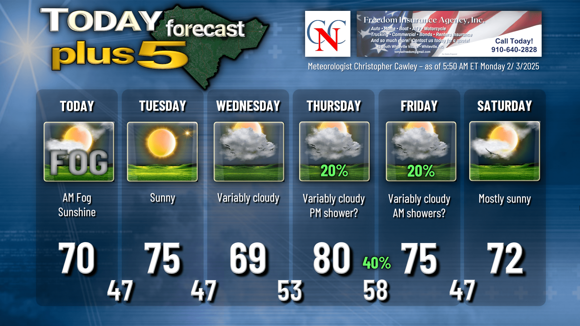
We’re off to a foggy start in many areas this morning thanks to a strong inversion at the surface. It’s going to take a good minute for the low clouds and fog to burn off this morning… but it will… and we’ll be left with a sparkling day, tons of sunshine with highs around 70.
High pressure south of Florida will bring a westerly wind flow to the area Monday night through Tuesday. There’s not much to talk about … blue skies and light westerly winds on Tuesday means a warm day with highs deep into the 70s. Get out and enjoy it.
Next up is a weak, dry cool front that will move through the area late Tuesday night and Wednesday. This brings a bit more cloudiness on Wednesday along with slightly cooler temperatures… our highs will be in the upper 60s to around 70. This is still 12-15 degrees above normal, so no complaints.
A warm front lifts north Wednesday night, introducing very warm temperatures into the area in a southerly/southwesterly wind flow. Also on Thursday, our next system starts to take aim on the area. With the latest guidance, it appears that deeper moisture increases during the afternoon ahead of a cold front. To that end, I’m going to introduce a chance for some showers on Thursday. We’ll go with 20%. It certainly won’t be a wash-out and most of the day should be dry. Our highs flirt with 80 degrees in that southerly flow, and it’s actually going to be a bit on the humid side during the afternoon!
Shower chances exist Thursday night into Friday morning with the frontal passage. Model blends indicate that total rainfall will be light from this system, and I don’t really see any reason to disagree. I’m only going with 40% chance for Thursday night. I don’t think this will be much to get excited about.
For the weekend, things get wishy-washy. On Saturday, the front gets hung up along the Savannah River and a little coastal trough tries to develop once again. At this point I’m going with sunshine for Saturday but that will hinge on development of the trough.
That same front gets pulled back north as a warm front Saturday night. Some clouds with that, but I think we’ll stay dry. Sunday is looking quite warm as we get firmly in that warm sector, with highs back up to near 80. Much better rain chances (and colder temperatures) arrive early NEXT week with the arrival of the next cold front. This is the front that will probably usher in a period of colder temperatures (closer to seasonal normal values) through the middle of February.
LONG RANGE: As I mentioned, a cooling-off period is more and more likely toward mid-month. Deterministic modeling has Columbus County on a wild rollercoaster ride with temperature swings, but when we’re looking so far out in time, it’s best to take the deterministic mods and chuck ’em in the trash. Ensembles is the way to go as they take away those peaks and valleys and “smooth” things out. As was the situation yesterday, there is a wide variance in the ensemble ranges, though, so the precise details remain just as foggy as our skies this morning.
An active pattern also appears to become established for Feb 11-16 leading to improved rainfall chances here and, yall, as much as I love sunny and 72, we really do need a couple days where it’s about 52 with a soaking rainfall.
Here’s your Freedom Insurance Today-Plus-5 forecast:
Ok friends, that’ll wrap up today’s report. Thank you for reading and for supporting Columbus County News. I hope you have a fantastic day, and as always, take care.
~Meteorologist Christopher Cawley