Welcome to the Sunday edition of the CCN Weather Update, brought to you by our friends at Freedom Insurance in Whiteville. For car, home, or future, Freedom Insurance has your back. Stop in or give them a call at 910-640-2828 and their professionals will put together the best policy for you!
STATISTICS FOR WHITEVILLE – Saturday February 22, 2025.
High: 56.8°F at 3:53 PM (normal is 60)
Low: 23.9°F at 6:53 AM (normal is 35)
Precip: 0.00 in
View live, real-time weather data for Whiteville on my College Street Weather Station.
Here’s your Bottom Line for today…
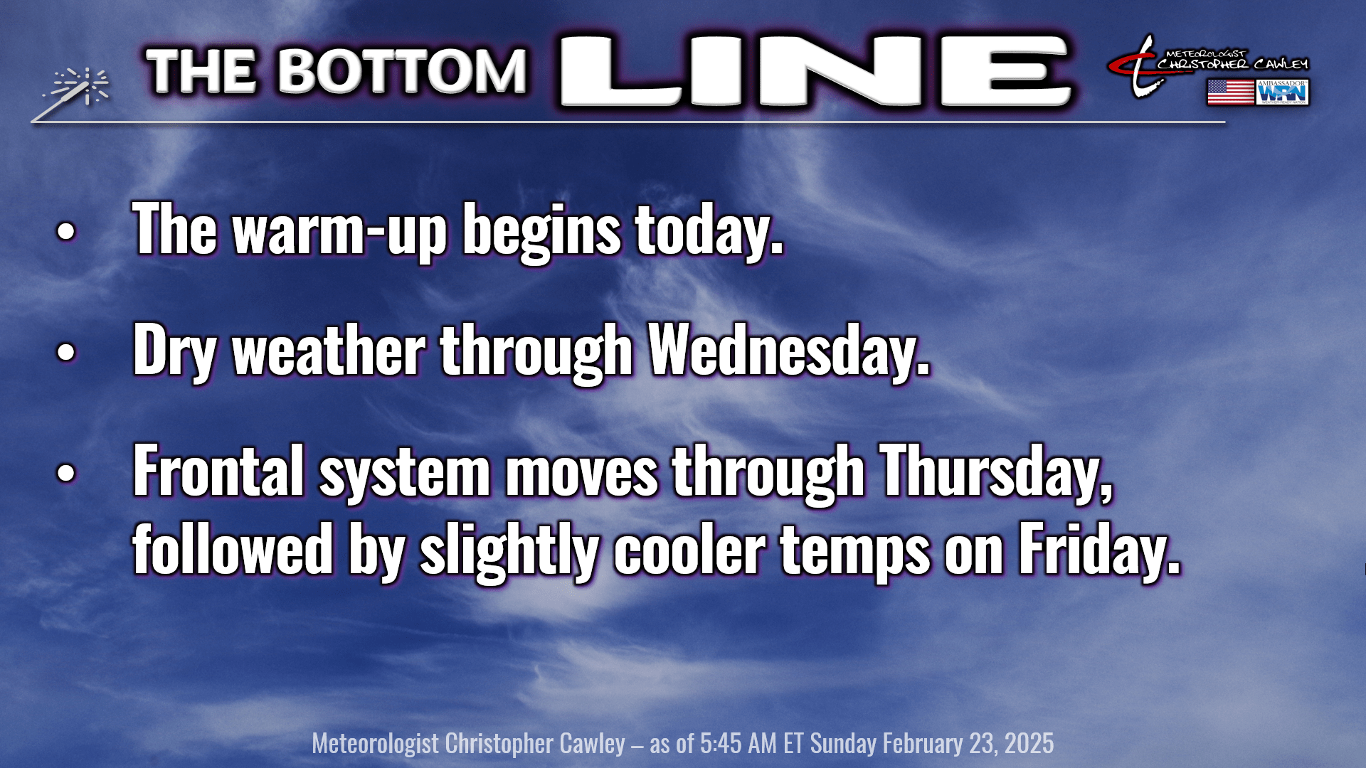
The bottom line graphic really covers it all. There’s just not a whole lot to talk about as we’re in a very quiet weather regime through the midweek period.
If you’re interest in getting technical and looking at the little details, I got you! Ridging high pressure and associated “subsidence” (sinking air) will support lots of sunshine across the county today. We may see some patchy high clouds of the cirrus variety later in the afternoon. Cirrus clouds are caused by ice crystals very high in the atmosphere. See the graphic above to visualize cirrus clouds.
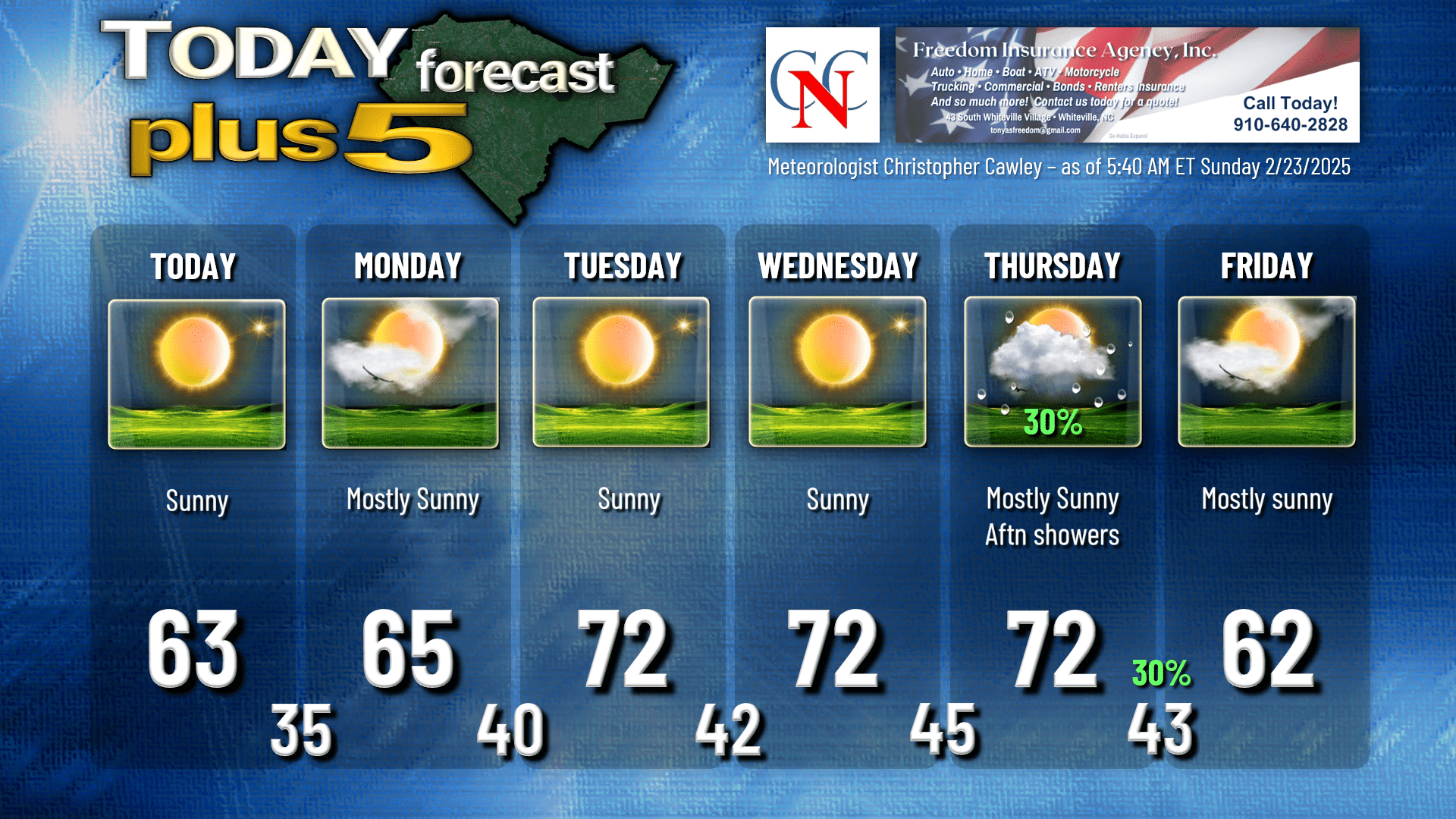
For Monday, a little bit of a disturbance may bring us a bit more cloudiness from time to time, but on the whole I’m expecting a pretty nice day.
Whatever cloudiness we have on Monday becomes a memory by nightfall, and clear skies will be the rule through Tuesday. Temperatures jump into the lower 70s Tuesday afternoon on southwest breezes ahead of a “cold” front (if you want to call it that). This front will be nothing more than a shift in winds and a few clouds Tuesday night, but that’s short-lived as southerly winds take control once again on Wednesday. Temps in the lower 70s will be commonplace.
Our next real front will approach Thursday and move through Thursday night. There will be some low-level “baroclinicity” with our front on Thursday. Side note — Baroclinicity is a condition in the atmosphere where there’s a bit of a temperature gradient along a pressure surface. Technogeek speak there. Anyway, baroclinicity can enhance the intensity of a low-level jet stream transporting moisture into an area.
So on Thursday our front will have the aforementioned baroclinicity along with some decent upper-level dynamics (essentially such things as forcing and lift to generate precipitation), and therefore we will have the chance for some afternoon showers. The whole thing is weak, though, so I’m still only going with 30% chance for rain Thursday and Thursday night. Many places won;’t get a single drop.
Front moves through Thursday night, rain chances, meager as they are, come to an end, and we return to plenty of sunshine for Friday. Temps will be a bit cooler behind the front, but that doesn’t appear to last long as the National Model Blend points to temps back into the upper 60s for next weekend.
No signs of any deep Arctic cold spells through at least March 10th. That doesn’t mean we won’t have temps flirting with the freezing mark, just no indication of “hard freeze” conditions (temps 28 or below).
Here’s your Freedom Insurance Today-Plus-5 forecast for Columbus County.
That’ll do it for today. Thanks for reading, and as always, take care!
~Meteorologist Christopher Cawley