Hello friends and neighbors, and good day to you! Welcome to the CCN Weather Update for TGIF Friday May 23, 2025.
This weather update is sponsored by Freedom Insurance of Whiteville. When severe weather strikes, with Freedom Insurance you will always be prepared. For home, car, boat, or whatever you need, Freedom can provide customized coverage to keep you and your family safe. Contact Freedom today at 910-640-2828!
STATISTICS for Thursday 5/22/2025
High: 90.0°F at 5:18 PM (Normal 82)
Low: 62.7°F at 6:38 AM (Normal 59)
Precip: 0.00 in
Precip – Month: 6.37 in
View real-time data from the weather station at College Street Weather Station.
Here’s today’s Bottom Line
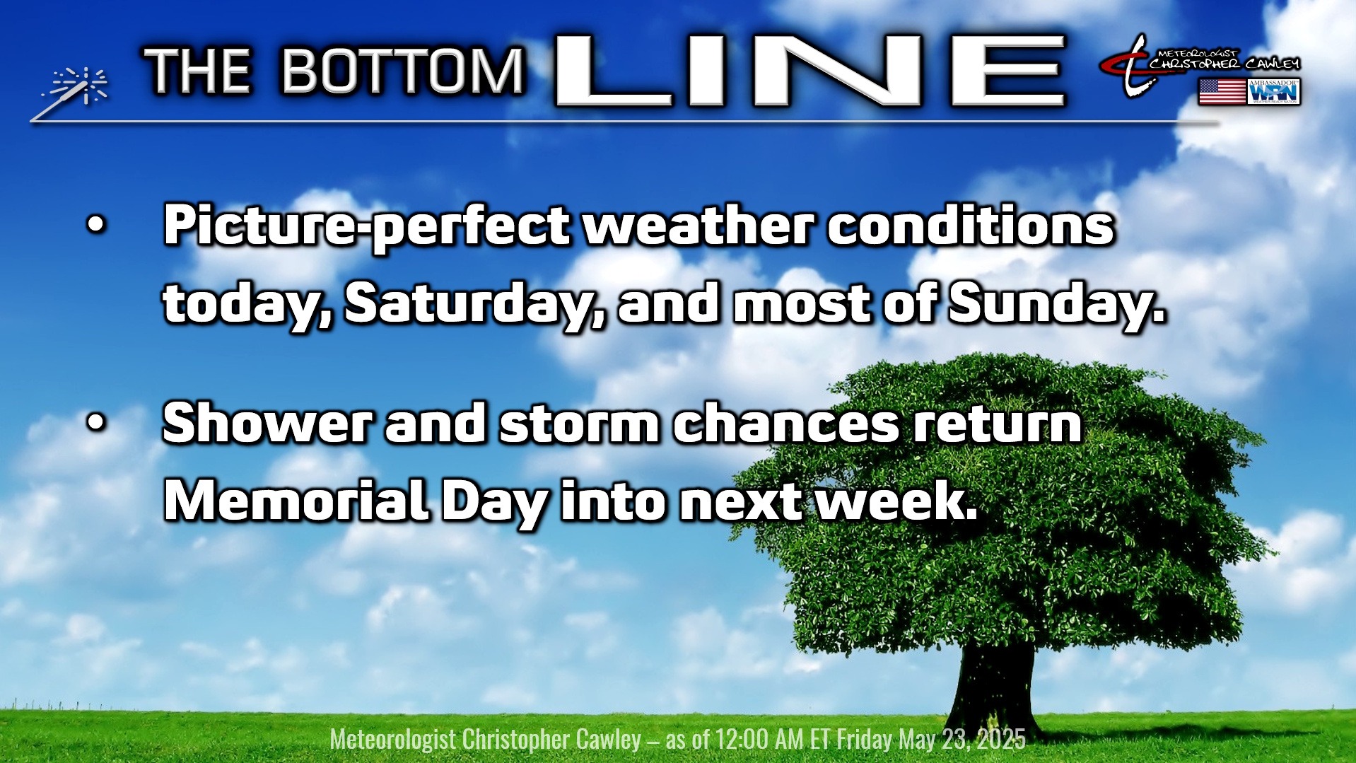
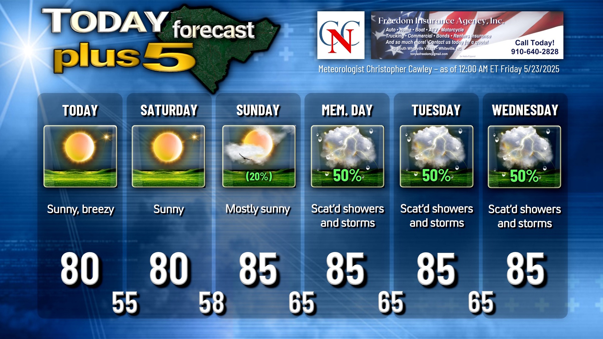
Today and tomorrow will feature some of the nicest weather we could possibly want across Columbus County for late May. Unlimited sunshine (even clouds will be hard to come by) with temps slightly cooler than normal by day, and considerably below normal by night…. my mentor, Meteorologist Rich Lupia, used to say on TV, “get out and enjoy it.” You have my permission to call out of work today to … get out and enjoy it.
A strong high pressure ridge is responsible for this goodness. This high will slip off the coast later on Sunday, allowing a bit more moisture to push in from the south… along with a faint warm front… and this will result in the slightest chance for a shower or storm Sunday afternoon. Highs push back into the mid 80s with dewpoints going into the 60s.
A bit of a coastal frontal boundary takes shape on Memorial Day. At the same time, a broad area of low pressure will build across the southeastern US. A series of weak boundaries will visit our area most of next week. This will mean scattered showers and thunderstorms each day next week, with the best chances honestly coming Tuesday and Wednesday. I’m going with 50% for Monday through Wednesday. I don’t think we’ll see all-day washouts; however, expect a mix of sunshine and clouds, warm and humid, with “occasional” storms about the area. It’s impossible to truly predict when/where the storms will occur.
TROPICAL WEATHER FORECASTS are returning as of June 1st, the official start of hurricane season. The National Hurricane Center released their 2025 outlook, calling for an above-normal season with 13-19 named storms are possible, with a handful becoming “major hurricanes.” People tend to become fixated on these forecasts, and honestly I look at them with a bit of an “mmmkayyy, whatever” attitude. There could be 50 storms that roam the open oceans. There could be 50 “major hurricanes” that develop. If none of them hit our area, how many people would honestly say that it was a “historic” or “above normal” season? On the flip side, say there are only 2 or 3 “major hurricanes” … but both of them just happen to make landfall along or just south of the NC/SC line and take a direct path over Columbus County… then of course we’d say it was a devastating season! So my point is take these forecasts and numbers with a huuuuge grain of salt. It only takes ONE strike, similar to Matthew or Florence, to make this a season to remember. Again, forecasts will resume on June 1st (unless something develops sooner, which is highly unlikely at this time). In the meantime, it’s pointless to lose sleep worrying about it.
Here is your Freedom Insurance Today-plus-Five Forecast:
That’s going to do it for today’s report. As always, thank you for reading and for supporting Columbus County News. Have a great day!
–Meteorologist Christopher Cawley