CCN Weather Update for Tuesday July 29, 2025.
This weather update is sponsored by Freedom Insurance of Whiteville. No weather worries with Freedom Insurance. For home, car, boat, or whatever you need, Freedom can provide customized coverage to keep you and your family safe. Contact Freedom today at 910-640-2828!
Here’s today’s Bottom Line
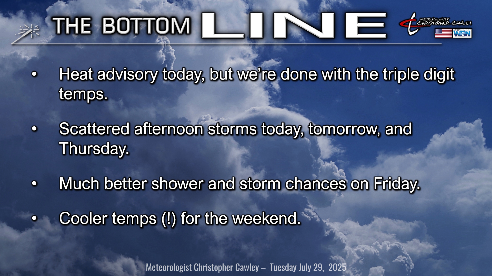
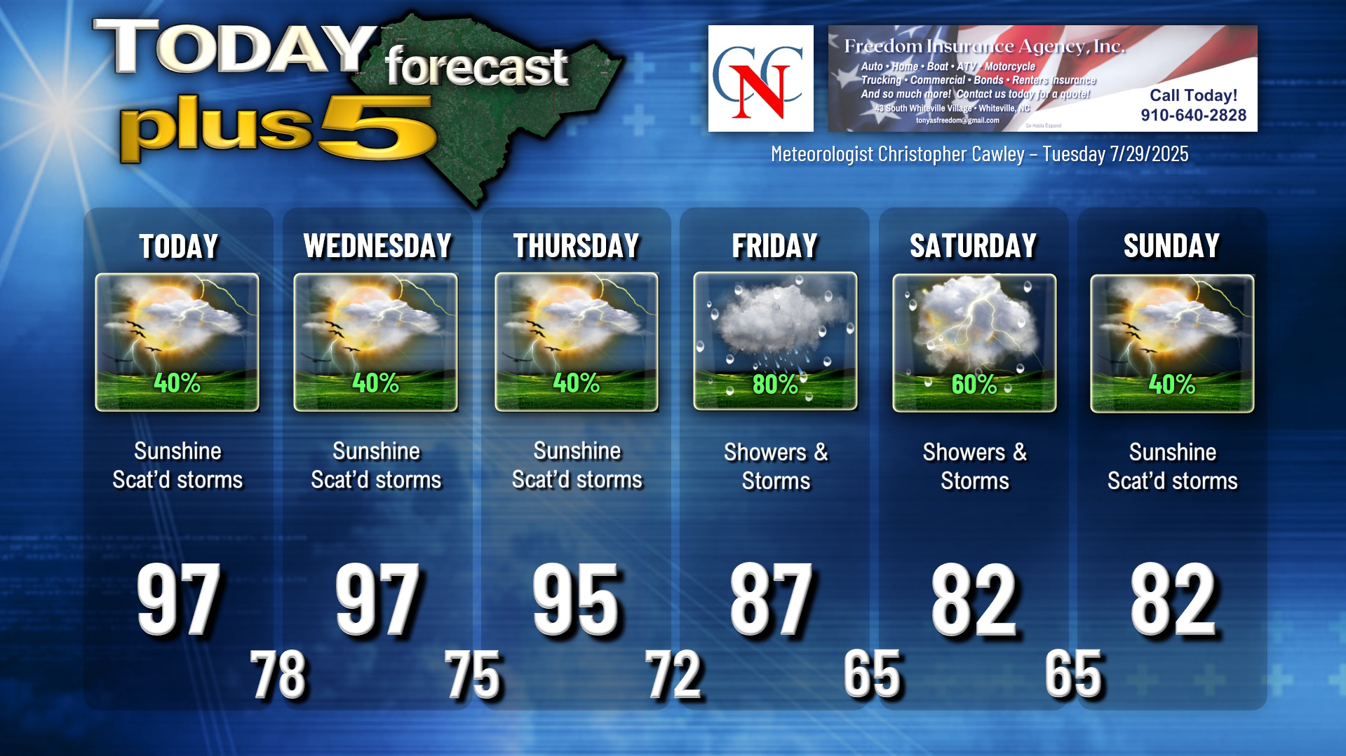
The good news is that we’re done with the triple-digit heat, maybe for the season (one can hope). But, a heat advisory is up for today as our highs will still reach the upper 90s with heat index values 105-110 this afternoon.
The high pressure “heat dome” responsible for this miserable heat is pushing westward. This will allow a bit of a broken trough to become established over the area. There are numerous outflow boundaries over the area, and these, combined with the sea-breeze and this weak little trough, will allow for the development of at least scattered thunderstorms later this afternoon.
Much of the same in terms of conditions for Wednesday with mostly dry and hot conditions, but at least scattered thunderstorms in the afternoon and early evening. Highs once again in the upper 90s, with probable heat advisory indices in the afternoon.
A broad-scale frontal system will start to approach the area on Thursday. A cold front will start the day running from roughly NYC southwestward through West Virginia, Kentucky, Arkansas and farther west. A ripple of low pressure spins up on this front, while high pressure pushes off to our southwest. All of this works to push the front southward toward the Carolinas. Expect partly sunny skies for Thursday with more scattered thunderstorms with highs in the mid 90s.
By Friday the cold front becomes draped across central and eastern North Carolina, extending westward through SC, GA, AL, and MS, with two waves of low pressure moving along it. Friday could turn out to be quite rainy/stormy with the front in place and these low pressure waves. The front and low pressure waves may slow down enough that the shower/thunderstorm activity continues through much of Saturday as well.
Most of this energy moves offshore by Sunday but I still think there’ll be enough moisture lingering that we see at least a few scattered storms.
The bigger story will be the DEFINITIVE END of the heat wave on Friday. I put a pair of 82’s on the chart for Saturday and Sunday… and our lows dip into the 60s for the first time since early June. Unfortunately it won’t be a “refreshing” 82, especially on Saturday as it will indeed be very humid, but Sunday could turn out to be quite the nice day with an “open the windows” vibe especially in the morning hours before that thunderstorm threat ramps up in the afternoon.
TROPICAL OUTLOOK: There is nothing of interest or potential development in the tropics at this time.
Here is your Freedom Insurance Today-plus-Five Forecast:
–Meteorologist Christopher Cawley