CCN Weather Update for Thursday August 28, 2025.
This weather update is sponsored by Freedom Insurance of Whiteville. Clear skies and easy sailing with Freedom Insurance. For home, car, boat, or whatever you need, Freedom can provide customized coverage to keep you and your family safe. Contact Freedom today at 910-640-2828!
Here’s today’s Bottom Line
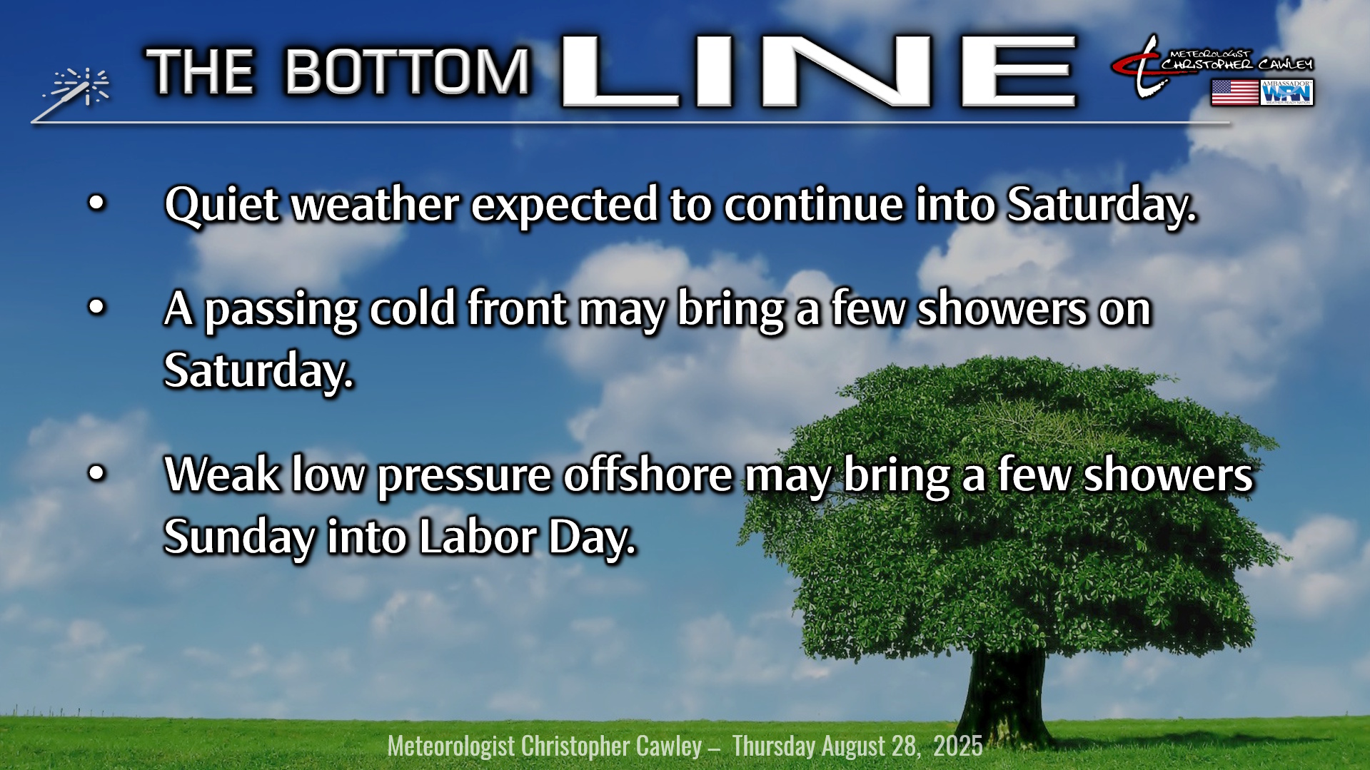
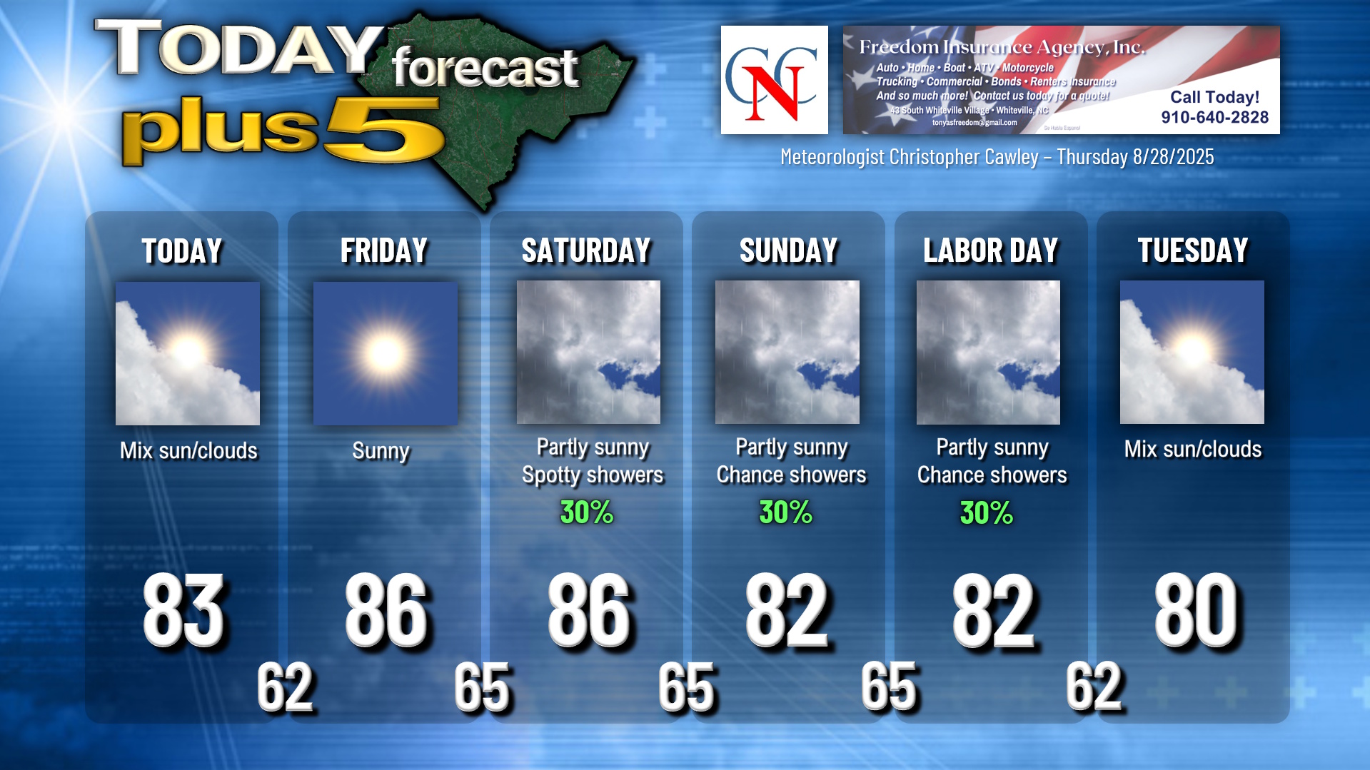
Quiet weather continues thanks to high pressure centered over Tennessee. A little bit of a coastal “trough” will bring some cloudiness to the area today, but I believe we’ll remain dry through the day. Spotty rain chances along the coast if you’re traveling to Wilmington or Shallotte or Myrtle Beach (20% at the worst).
That’s gone on Friday as high pressure moves eastward over western North Carolina. I thought yesterday that there’d be a wave of low pressure along a front just off the coast, but now it looks like that frontal boundary will be far enough south/east that the high-pressure cell will win the battle. Therefore, I’m going with a mostly sunny forecast for Friday with warm temps but low humidity.
A cold front starts to approach from the northwest Friday night and this should cross the area sometime Saturday. I think we’ll see a mix of sunshine and clouds, but with this frontal boundary in place comes the chance for a few showers. I don’t think there’ll be anything significant, and the modeling doesn’t really look all that impressive, but keep an umbrella handy for your Saturday plans.
The front lingers to our south for the rest of the Labor Day weekend as low pressure forms off the SC/GA coast. This will lift slowly — slowly — off the coast Sunday into Monday keeping at least scattered rain showers in our forecast. I don’t think we’re looking at any washouts but probably some scattered activity. I’m capping the chances at 30%.
I’ll be watching the low as it might try to take on some tropical characteristics over the very warm water off the GA/SC coast on Labor Day. Right now, the NHC is NOT highlighting this area as an area of concern. Even if it does develop a closed circulation, the trajectory takes it north and east and away from the shore. No worries at all.
Speaking of tropics…..
TROPICS: Post-tropical cyclone Fernand clings to life support in the north-central Atlantic and, as I’ve been saying, will be no threat to anybody.
All else remains quiet across the tropics, which is RARE for the Labor Day time period.
A tropical wave, the one that we were watching as “Invest 99L” near the Leeward Islands, continues to have some disorganized showers and thunderstorms near the center of the wave, but this is encountering shear and is not in a good development environment as it moves through the central Caribbean.
There’s another wave off the African continent with some moderate thunderstorm activity, but it’s not organized, and no development is expected from this.
There are no tropical threats to the Carolinas for at least the next 2 weeks.
Here is your Freedom Insurance Today-plus-Five Forecast:
–Meteorologist Christopher Cawley