Downtown Whiteville business owners are organizing an informational meeting to discuss flooding concerns and the new Madison Street Park project.
The meeting is set for May 12 at the old Mama Rita’s restaurant, 117 Mill Street.
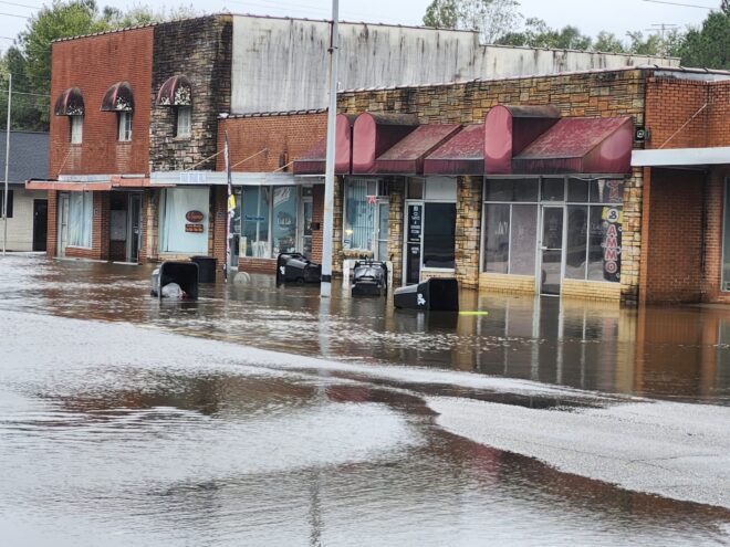
Former City Councilwoman Helen Holden owns Penn’s Grill. The Commerce Street landmark has been landlocked by flooding multiple times during hurricanes and high rain events. She said she has been questioning the purpose of the Madison Street Park since shortly after it was proposed.
“We all agree that a park would be a nice feature to bring people downtown,” she said. “The concern is whether or not the park will actually increase flooding for downtown businesses, or if it will improve stormwater runoff.
“I can’t get a straight answer. I couldn’t when I was on the board, and I can’t now.
“Was the grant for a nice park, or for a park that helps flooding?”
City officials have been struggling with flooding downtown since before Hurricanes Matthew and Florence, which caused millions in damage. The city established a Stormwater Crew to remove beaver dams from Soules Swamp, clear drains and clean ditches throughout the area. Work is also planned or has been completed on stormwater projects ranging from improving underground infrastructure to enlarging drainpipes under the railbed, which acts as a dam during times of high water.
A grant through FEMA that would have improved Mollies Branch was rescinded by the federal government before work began.
Whiteville typically gets hit in two directions during major rain events: water flowing down Soules Swamp, and water backing up from White Marsh.
When the two waterways meet, the water can cover Thompson Street from the railroad past Talbot. High water backs up onto Lee at Madison, flowing down Cypress, Frazier, and Commerce streets.
Soules Swamp flows into White Marsh below the city, but when the marsh is full, runoff is slowed and the marsh flows backward into downtown.
The floodwaters from Soules and White Marsh converge at Commerce Street, just below the Madison Street Park.
The park sits on what was once the Lewis Smith Shopping Center. The buildings were damaged by Matthew, Florence and other flood events, and were empty when a fire swept through the structures on Feb. 2, 2021.
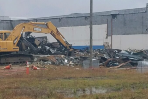
The city eventually took over the property and demolished most of the structures, removing acres of pavement from the parking lot to allow rainwater to soak into the ground. Plans are in place to clear more structures along Frazier, eventually leaving only the storefronts along Madison in place.
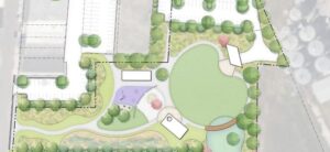
Ground was broken last year for a three-stage park project paid for through grant funds and private donations.
Plans call for around three acres of impermeable surfaces at Madison Street Park to be replaced with grass and trees. A holding pond was also built to allow water to slowly drain into Soules Swamp.
Downtown Economic Development Director Madison Ward and Planning Director Robert Lewis are coordinating the project for the city. Withers Ravenel secured funding for the park through the state Land and Water Conservation Fund and the Rural Transformation Grant program.
The design firm’s webpage on the Madison Street project says the property was identified as a good candidate for a park that not only provides recreation area downtown but can also help alleviate some flooding.
“The space… includes a performance stage, large open lawn space, playground, splash pad, and other site amenities in addition to parking and a strong pedestrian connection to Madison Street,” the firm said in its project portfolio, available here Whiteville Madison Street Park – Portfolio – WithersRavenel.
“While they will not solve the entire problem, plans for the community space include features that will contribute to managing these flood events,” the firm said. “Upon completion, the project will build resiliency and spur economic activity in addition to providing a central space for the community to gather and connect.”
Withers Ravenel conducted surveying, environmental investigation, and is overseeing construction. Construction of Phase One was expected to be completed this spring, but has been delayed.
Holden said she is also concerned that the park would do better with another type of grass, other than Bermuda, which tends to create a thick mat that increases runoff, rather than absorption. Artistic renderings of the park show multiple trees, but currently the plan only calls for two cypress trees to be planted near the bandshell.
Holden and several other residents have noted that the planned bandshell will be constructed facing the west, putting in full sunlight during the hottest part of the day, especially during the evening hours when planners hope to have live bands and other entertainment. That location could also redirect sound toward the downtown area.
Placing the bandshell at the side of the park along Wilson Street on higher ground toward the north and northwest would provide easier access to utilities, service, and backstage functions. The Wilson Street side would also allow the shell to orient toward the south, directing sound toward the swamp as opposed to downtown, Holden said.
Holden noted that changing the location of the bandshell could disrupt the project, but it would have benefits in the long run.
“A west-facing stage is wrong for this ground,” she said in an email to the city. “It will be hotter, harsher, and louder where it should be more comfortable and more wisely directed.
“There is still time to place it where the land, the light, and the sound all work better together.”
Holden said she is in favor of the park, which could provide a valuable feature to an area that would otherwise remain vacant.
“People just want to see it done right,” she said. “We have questions that need to be answered.”
The May 16 meeting is at 6 p.m. and is open to the public.
City Manager Sean Martin did not immediately return an email request for comment. His response will be added to this story when he replies.
Copyright 2026 Columbuscountynews.com. All Rights Reserved.