Good evening folks, sorry for the late update (the internet gremlins hit), but here’s your weather report for Sunday November 3, 2024.
We have some things to talk about, including the potential for some very-much-needed rainfall in Columbus County this coming week.
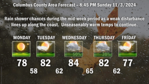
Strong high pressure will push off the New England coast on Monday. This will then drift southward keeping unseasonably warm temperatures in our area. Meanwhile, a “trough” of low pressure, which is known as a disturbance in the middle levels of the atmosphere, is likely to develop right along the coast during the midweek period. This may kick off some rain showers east of I-95. Modeling suggests most of the rain from this will be over Horry and Georgetown counties, but some rainfall here as well. This would be Wednesday into Thursday. A weak cold front moves over late Thursday night, bringing an end to the rain chances for this forecast period.
As for temperatures, they are going to remain well above seasonal normal values. Highs in the upper 70s Monday will push into the 80s Tuesday-Thursday, before falling back to the upper 70s by the end of the week. Lows will be more along the lines of what would be expected in September… ranging from the upper 50s to mid 60s.

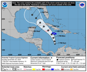
Tropics: FINALLY we have what will become Rafael in the Caribbean Sea. This is likely to reach hurricane strength, as shown by the NHC graphic, reaching the Gulf of Mexico and weakening by the end of the week. This should weaken because modeling is showing quite a bit of shear and dry air over the northern Gulf by mid- to late-week, which is hostile to sustaining a tropical system. It is possible (but definitely not certain) that this gets absorbed into the tail end of the cold front that crosses our area early Friday. If this occurs, the remnants will likely slide northward through Georgia and the Carolinas. That’s all speculation and “wishcasting,” though, so take that with a grain of salt.
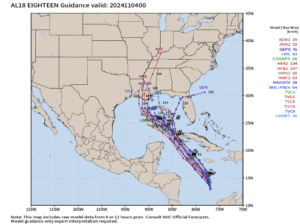
Hurricane Center spaghetti model plots are consistent with the official NHC graphic as far as the path goes. The spaghetti plots do NOT show this connecting with the frontal boundary; instead, the modeling suggests lifting north and dissipating over Louisiana or Mississippi.
That’ll do it for tonight’s update. It’s good to finally have some weather to talk about. We definitely need whatever rain we can get mid-week. Thanks for reading, and as always, take care!


