Greetings friends, welcome to the FRIDAY edition of the CCN Weather Update!
Hey at least it’s not as bitterly cold this morning!
Today is a “transition day” weather-wise. A more moist air mass will push into the area thanks to frontal system that is slowly approaching from the west. We should stay dry with mostly sunny skies through the day… maybe some more cloudiness this afternoon. Seasonable highs in the mid to upper 50s.
We become overcast tonight. The latest high-res guidance suggests periods of rain start developing by around daybreak Saturday. Periods of rain continue through early Saturday afternoon. The guidance suggests a break in the rain for the remainder of the afternoon, with another round of showers moving in Saturday night… with that window open until roughly noontime on Sunday.
Guidance suggests rainfall amounts are going to be a little bit less than originally thought, but I still think we’re going to see between a half and three-quarters of an inch of rainfall through this event. Not a drought-buster, but every little bit helps.
Temps this weekend will be seasonable by day, with highs in the mid 50s. Lows tonight/Saturday morning drop to the lower 30s. Not much drop Saturday night thanks to clouds and showers… minimum temps will remain in the mid to upper 40s.
The cold front finally pushes through Sunday afternoon, and cold air comes blasting in Sunday night. Temperatures tumble deep into the 20s early Monday morning.
NEXT WEEK:
High confidence — Bitterly cold air in place.
Low confidence — Precipitation and storm track.
Today’s modeling has done an about-face with regard to our “maybe storm system” for next week. If you DON’T want snow or ice, today’s update gives you some hope. If you were hoping for a snowstorm event, well, the uncertainty is higher today than it has been over the past several days.
Scenarios:
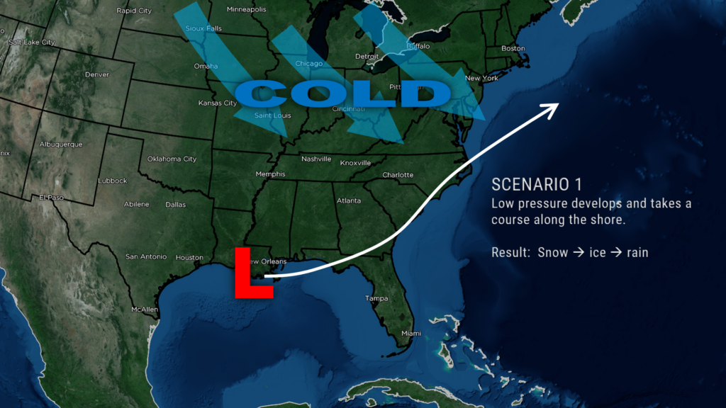
Scenario #1. Low pressure forms along the northern Gulf coast and moves along or just inland from the coast. This brings a snowy start, but like last Friday precipitation quickly transitions to freezing rain and then rain as warmer (relatively) air filters in.
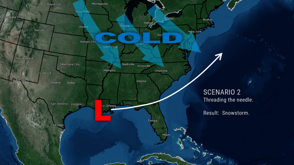
Scenario #2. Low pressure forms along the northern Gulf coast and then “threads the needle” in a Goldilocks Zone just off the coast. Far enough that cold air stays locked in place, but close enough that enough moisture spins in. The result would be a legitimate snowstorm for areas between I-95 and the beaches.
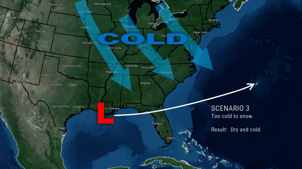
Scenario #3. Low pressure forms along the northern Gulf coast… but the strength of the Arctic high pressure, and the depth of the cold air, pushes so far south that it “shunts” the storm directly to the east and off the coast.
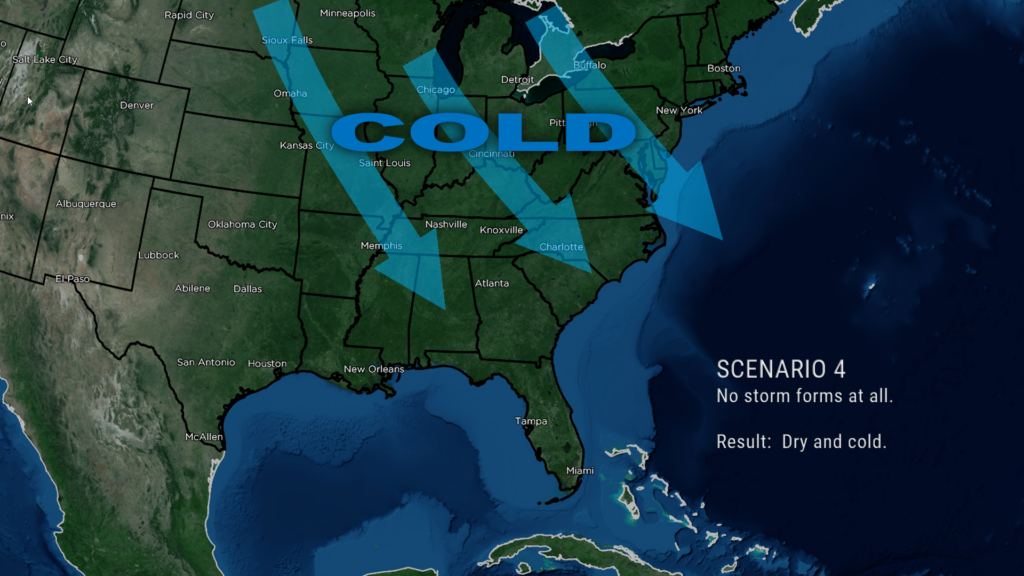
Scenario #4. Nothing forms at all and we remain dry and bitterly cold next week.
The latest deterministic GFS and Euro models favor scenario #3. The latest deterministic Canadian and ICON favor #2 and show “Biblical” level snowfall here. While a snow event remains possible, double-digit accumulations just aren’t going to happen.
The GFS and Euro ensemble members are trending southeastward. They still point to snow/sleet here but they’re pointing at a stronger Arctic high pushing down over the eastern United States, resulting in less overall accumulations.
The model blend chart has Columbus County in a 30% to 40% risk for 1 inch or more snowfall from Tuesday through Wednesday. Recall that yesterday we were at 60% to 70%. That’s quite a change.
So, my forecast is for a) bitterly cold conditions, and b) a 30% chance for snow Tuesday afternoon, Tuesday night, and Wednesday. I’m just not comfortable going any farther than that at this point. Prepare for a storm… that is still a possibility at this point. But just as equal is the potential that we get nothing at all and remain in a deep freeze.
Temperatures: My gosh, it has been a cold January thus far, but this will be the icing (no pun intended) on the cake. Now there is some doubt with temps given the storm track. Assuming a scenario #3 or #4 storm track, our highs on Tuesday will struggle to reach the 30°F mark. Morning lows by next Wednesday could very well fall into the single digits above zero, especially if we have clear skies. Folks, that’s pipe-bursting, dangerous cold.
Should the storm track up the coast, our temps overall will probably be in the 34-39 degree range through the storm. The “thread the needle” track has highs 30-35 with lows in the upper teens.
The NWS will issue Cold Weather Advisories for temperatures between 6°F and 15°F. Extreme Cold Warnings will be issued for any temperature or wind chill of 5°F or less. It’s a near-certainty that advisories of some form will be required next week.
Honestly… I think the bitter cold is a bigger threat than any wintry precipitation at this point.
Okay friends, that wraps it up for today’s report. Thanks for reading, thanks for supporting CCN, and as always, take care.
~Meteorologist Christopher Cawley

