Hey everyone, welcome to the Thursday 1/16/2025 edition of the CCN Weather Update!
Brrr. Mercy it’s cold out this morning with temperatures running in the upper teens to lower 20s. At least we don’t have a lot of wind to make things worse. But still, we’re off to a cold start.
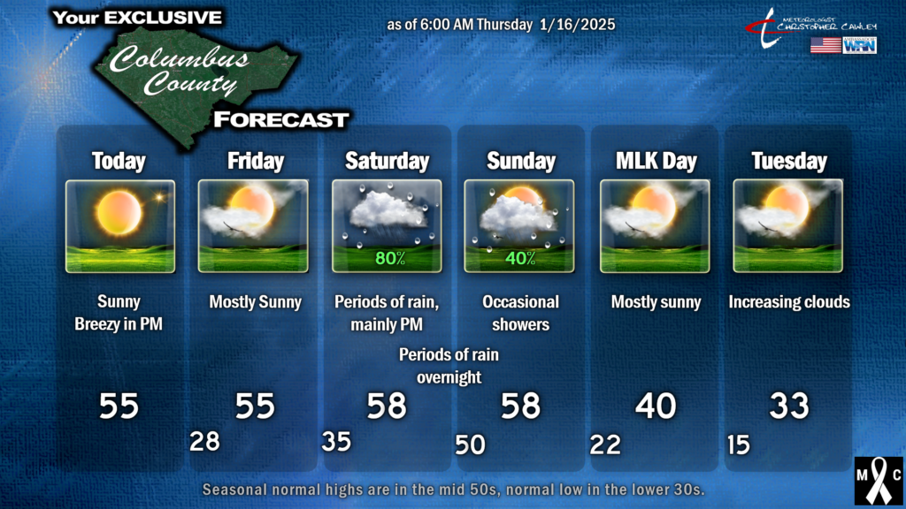
High pressure pushes offshore later today while a massive area of low pressure turns over Hudson Bay (Canada). The flow around these two entities turns our breezes to the southwest today, and that will help push our temps up to seasonal normal values this afternoon (mid 50s).
We’re quiet through Friday ahead of our next weather system, which arrives for the weekend. A continued southwesterly flow means another day with temps generally in the middle 50s on Friday, with considerable sunshine (although some cloudiness may increase later in the afternoon).
A frontal system approaches on Saturday and gets kind of “strung out” in a northeast to southwest orientation. The slow-moving system, with the possibility of a wave of low pressure forming on it, points to periods of rain across the county from Saturday afternoon through about lunchtime on Sunday. Temperatures will be mild but not quite as warm as I had originally anticipated… I think we’ll be in the upper 50s to near 60 both Saturday and Sunday.
As for rainfall amounts, the GFS is coming in a bit heavier than the Euro. Model blending depicts roughly three-quarters of an inch of rain from noon Saturday through noon Sunday, and I don’t see any reason to disagree with that.
Temperatures absolutely plummet after the sun goes down on Sunday. There might be a little bit of moisture leftover, and if that’s the case, I can’t rule out the potential for a few snow flurries during Sunday evening. Skies then rapidly clear out and the coldest air of the season enters the picture.
We’ll wake up on Martin Luther King, Jr., Day with temps in the lower 20s. Ok, so that’s not all that unusual this month… but our highs will struggle to reach 40 degrees, even with plenty of sunshine.
Temps fall to the lower and middle teens Monday night/Tuesday morning, and a Cold Weather Advisory is almost certain at this point. Our HIGHS on Tuesday will be lower than the coldest normal LOW at this point… highs Tuesday 30-35.
Now our focus turns on to what could be a significant winter storm for the area… or what could be a whole lot of absolutely nothing.
Frigid air from Siberia spilling over the north pole, diving southward across the eastern United States, will keep our area in the deep freeze. That much is certain.
Low pressure is expected to develop along the northern Gulf of Mexico. Where this low goes is still really up in the air at this point. It could take an inland track over GA, SC, and eastern NC, which leads to ice and then rain, similar to the last system. A track right along the coast indicates snow transitioning to a rather impressive ice storm, then ending as snow. A track about 100 miles offshore points to a bonafide snowstorm here. If the low tracks farther offshore, we get nothing other than a reinforcing shot of brutally cold air.
At this juncture, each solution is equally as possible/plausible.
On my FB page earlier on Wednesday I wrote a LONG post about models and model ensembles. I won’t rehash that here. Feel free to go to @MeteorologistChristopherCawley on FB to learn about those details.
Ensemble modeling, from the GFS side of things (30 total ensemble members plus a control), we have 13 out of 30 ensemble members pointing at the potential for snow Tuesday/Wednesday.
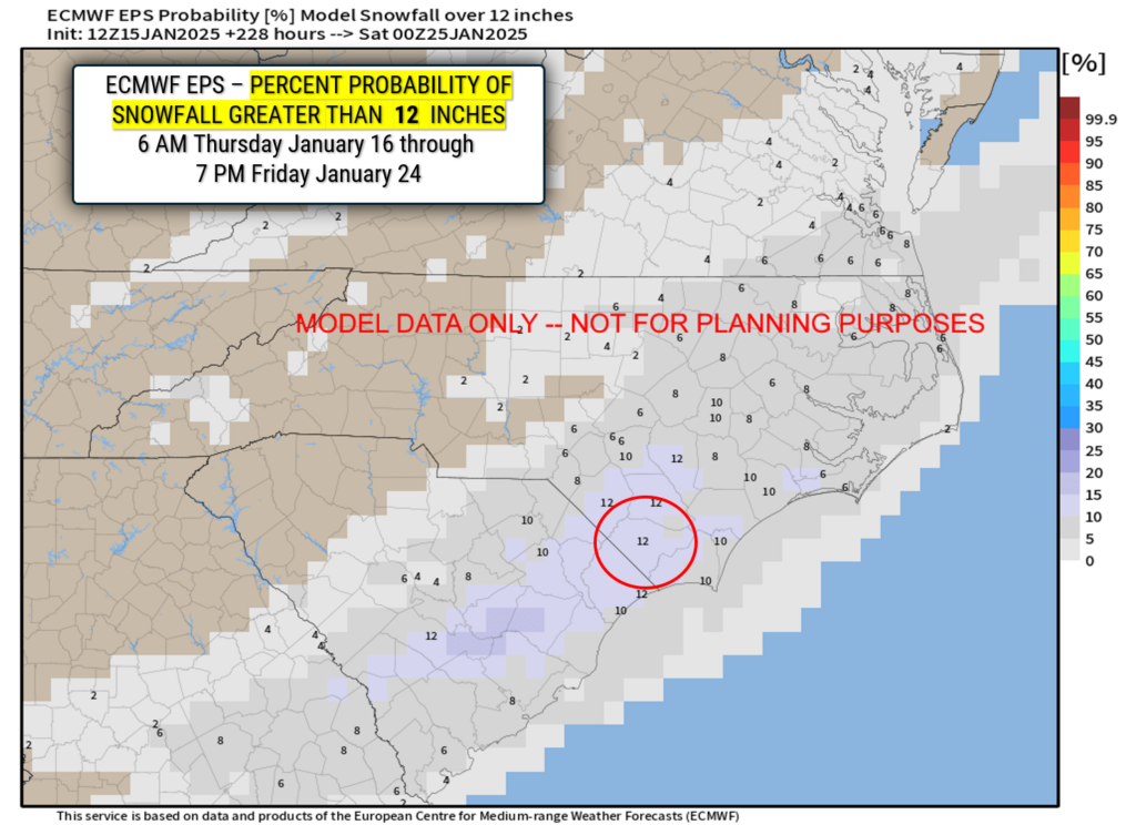
From the European side (50 ensemble members plus a control) shows 41 out of 50 members pointing at the potential for snow Tuesday/Wednesday. Some of these individual members are really displaying some eye-popping totals, including 12 inches, 17 inches, 14, 13, etc.
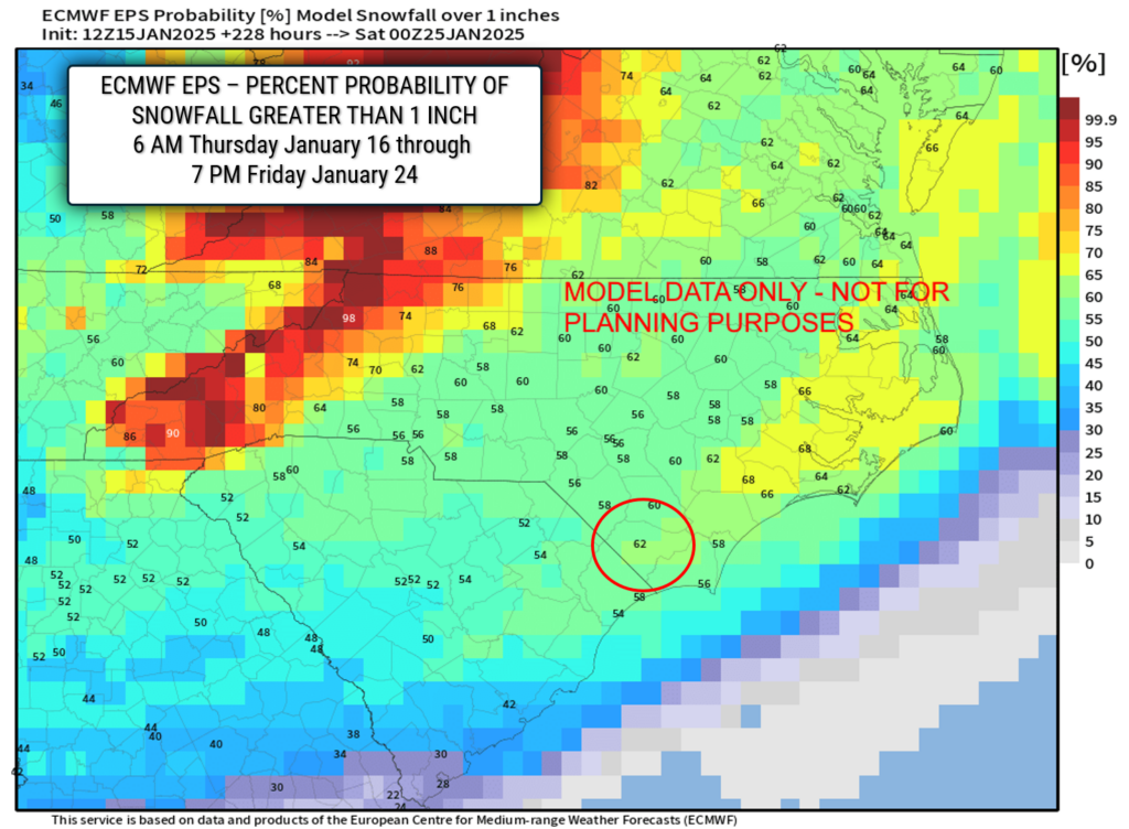
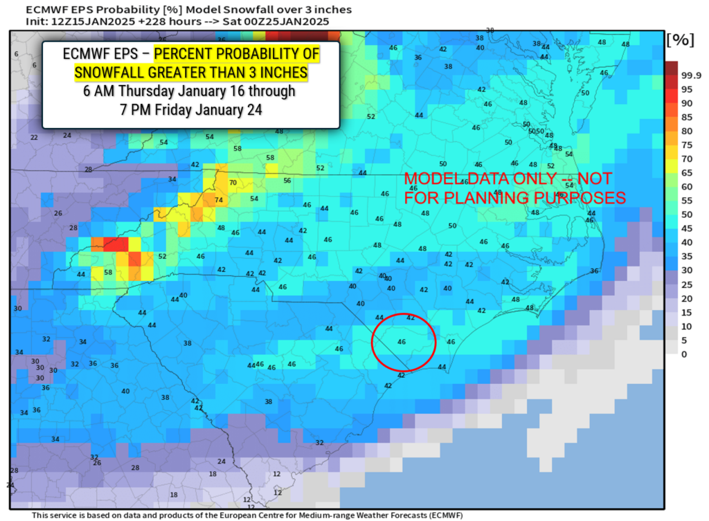
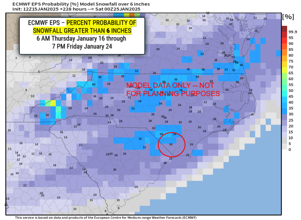
The latest percentages charts show very, very good chances for accumulating snow here. We’re talking 62% chance for greater than 1 inch, 46% chance for greater than 3 inches, 30% chance for greater than 6 inches, and a 12% chance for greater than 12 inches of snow. No that’s not a typo.
Now… again… I can’t stress this enough… this is all model data only right now. The storm in question hasn’t even developed. There’s a chance (a low chance, but a chance nonetheless) that the storm doesn’t form at all, and it’s just brute cold all week instead.
Like I said yesterday, we’re in “watchful waiting.” Stay tuned. I’ll start to know more by Friday, and definitely over the weekend. I will give my “first call” on snow/ice totals by Sunday morning’s report.
That’ll do it for today, folks, thanks for reading and supporting CCN! As always, take care.
~Meteorologist Christopher Cawley

