Greetings readers, welcome to the Tuesday edition of the CCN Weather Update.
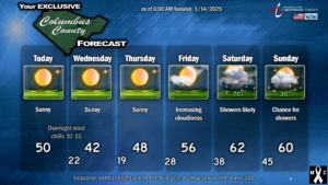
Dry weather — very dry air in place — with colder-than-normal temperatures will continue for much of the rest of the work week.
There’s not an awful lot to talk about through about midday on Friday. A cold frontal boundary will wander over the county later this afternoon and shift the light westerly wind to a northerly wind flow. There may be some very high cirrus cloudiness with the frontal passage, but that will be about it.
STRONG high pressure will push southeastward into the Carolinas by Thursday and then offshore by Friday. This will result in crystal-clear skies and a continuation of our unusually prolonged cold weather.
Tonight into tomorrow morning will feature lows in the lower 20s. Winds will be a bit blustery at times, possibly dropping wind chills into the lower teens. Wednesday night into Thursday morning will be very calm with once again clear skies. This sets up picture-perfect “radiational cooling” and we’re headed into the upper teens to around 20.
Thursday will feature slightly warmer temps as the high begins to shift offshore, and Friday will actually feature “seasonable” temps for a change… the first time since just after New Year’s.
Our next weather system approaches for the weekend. Model guidance just cannot seem to get on the same page with regard to timing and impacts. Southwesterly winds bring a warm, moist flow from the Gulf ahead of what will likely be a pretty potent cold front. Euro, GFS, and ICON all disagree on timing of rainfall and the frontal passage, so I’m going to let them argue in the corner, and go with gut instinct and experience for this call. I believe clouds will be rolling in by Friday afternoon, shower chances develop during the overnight Friday night. Showers are fairly likely on Saturday (with warm temps). To account for the model madness, I’ll throw in shower chances for Sunday but that may end up being nothing (NWS model blend doesn’t show anything in here on Sunday).

Are you sick of the cold? Well, guess what. There’s more coming.
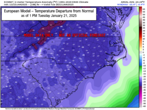
Global models suggest yet another lobe of the polar vortex dives southward over the central and eastern US as we go into next week (the 20th and beyond). The Euro operational model suggests our temperatures will be running some 25 degrees below normal by 1 PM Tuesday afternoon (the 21st). If this pans out, that would mean HIGHS struggling to reach the lower 30s, with the potential for low temps in the upper single digits. Woof.

The 50-million-dollar question then gets raised. Will it snow?
Guidance seems to suggest at something wanting to develop on the southern jet stream next Tuesday. That’s the generalized “big pattern picture” anyway. Where it goes is up for debate. Just like the previous system, an inland track leads to ice and rain here. A track right on the shore leads to a true-blue ice storm, and a track a hundred miles offshore means we get snow.
A friend of mine told me her phone app says we’re going to get 11-14 inches of snow next week. Phone weather apps are nothing more than model data, usually from the GFS model, or perhaps a combination of NAM and GFS or NAM and Euro. Either way, there’s no human quality control looking at the data. When she told me about the snow, I almost laughed out loud. Phone weather apps shouldn’t really be taken seriously, especially beyond about 48 hours out. But I digress.
I’m not even going to begin speculation on what might or might not happen next week. The “ingredients” responsible for any of this are on the other side of the globe right now, so no meteorologist or forecaster who is worth anything is going to make any calls at this point.
All that being said, we do have some members of the ensemble group indicating SOME snowfall here. We’ll see. 11-14? Yeeeaaahhh no.
Alrighty folks, that’ll wrap up today’s weather blog. Thank you for reading and supporting CCN, and as always, take care!
–Meteorologist Christopher Cawley


