Welcome to your CCN Daily Weather Update for Tuesday February 18, 2025.
Your CCN Weather Update is sponsored by Freedom Insurance in Whiteville. No matter your insurance needs, the highly qualified professionals at Freedom can work with you to develop the best policy for you. Call 910-640-2828 or visit their office near the south-side Hills, and their experts will provide you with the peace of mind you need.
STATISTICS FOR WHITEVILLE – Monday February 17, 2025.
High: 54.4°F at 3:31 PM (normal is 58)
Low: 34.1°F at 11:58 PM (normal is 34)
Precip: 0.00 in
View live, real-time weather data for Whiteville on my College Street Weather Station.
Here’s your Bottom Line for today…
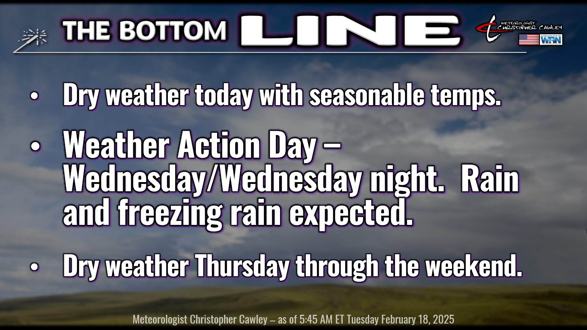
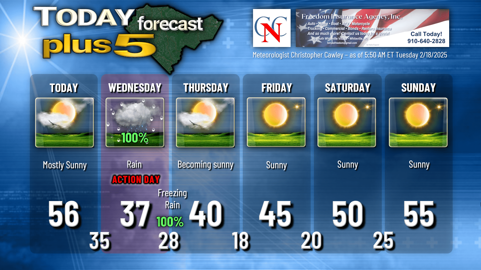
The calm before the storm for today. Lots of sunshine with seasonable temps as high pressure starts to give way to the coming storm.
An area of low pressure will form on the southern branch of the jet stream later this afternoon. At the same time, another disturbance dives southeastward from the Rocky mountains into the central Plains.
This all progresses forward tonight. Clouds will be on the increase tonight, and our temperatures will bottom out generally in the middle 30s.
The southern low transitions to the Georgia coast by early Wednesday morning while a large, sprawling Arctic high starts to build southward in the wake of the northern disturbance. As the coastal low takes the lead, cold air at the surface is “pulled” inward toward the coast. Warmer air (relatively speaking) will lift “up and over” the cold surface air and rain will develop. Expect a miserably cold day on Wednesday with widespread stratiform rain and temperatures holding steady in the upper 30s.
More colder air funnels in at the surface as we move through the afternoon and evening hours on Wednesday, while air that is located about 1000 feet off the ground is several degrees warmer. That warmer layer extends all the way up to the cloud base.
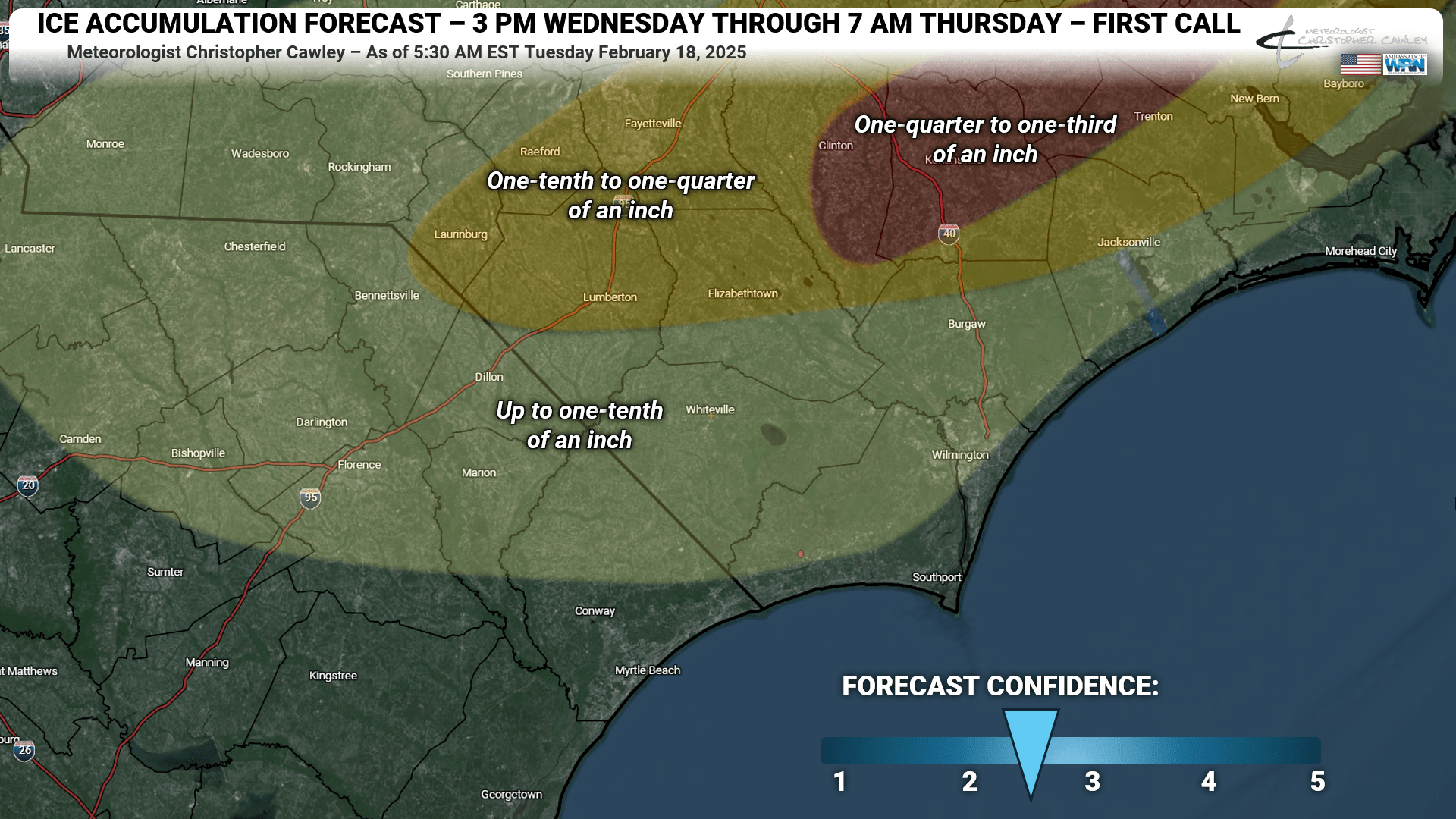
Eventually SURFACE temperatures Wednesday evening fall below freezing, leading to a freezing rain situation. I expect several hours of generally light freezing rain to occur over the county, with ice accumulations up to about a tenth of an inch. Some places possibly a little more, others possibly less (especially the eastern third of the county, east of the Waccamaw River).
Wouldn’t it be nice if the forecast was simple and straightforward? Nothing is that easy. Complicating our forecast is the potential for DRY air in the middle to higher levels of the atmosphere to wrap in during Wednesday evening. My ice accumulation forecast that is attached here has a relatively low confidence because I’m not sure how much this dry air aloft will “cut off” the precipitation.
For right now, again, for Columbus County I’m going with up to a tenth of an inch of ice accretion. Portions of Robeson, Bladen, Sampson, Pender, and Onslow counties are likely to receive up to a quarter of an inch of ice, and I painted in an area farther to the north where some places could receive up to a third of an inch of ice. That’s a true-blue ice storm for our friends up there. Ice accumulations will be less closer to the coast… Brunswick and the Wilmington area could see 0.01 to 0.05 inch. Here’s my ice accumulation “first call” forecast map…
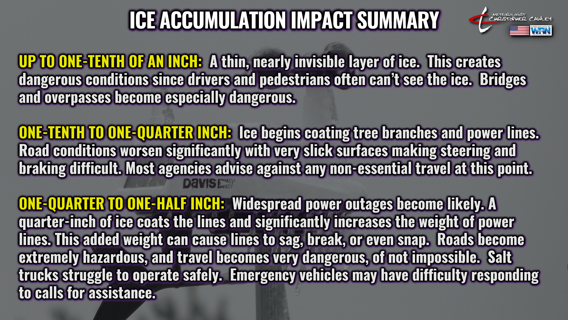
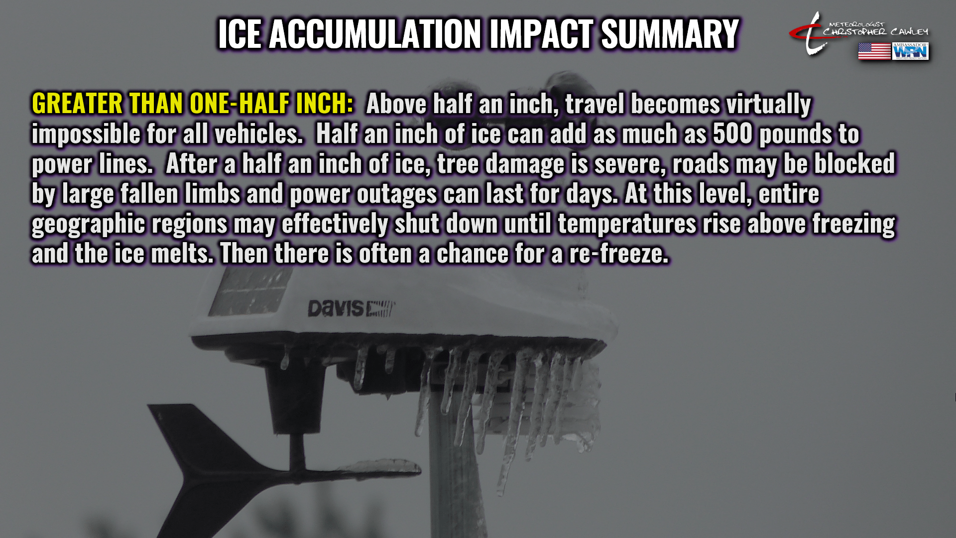
Different ice accumulations can have different impacts. I have created some slides here to detail what impacts can be expected.
The storm departs by Thursday morning and we’ll see a mix of sunshine and clouds throughout the day Thursday. COLD, Arctic high pressure builds in and we drop into the teens Thursday night/early Friday. Dry weather will stick around through the weekend with a general warming trend, but overnight lows will still be well below freezing. Dry weather is expected to continue into next week.
Here’s your Freedom Insurance Today-Plus-5 forecast for Columbus County.
That’ll do it for today. Thanks for reading, and as always, take care!
~Meteorologist Christopher Cawley