


Hello friends, welcome to the Wednesday edition of the CCN Daily Weather Update! Our update is brought to you exclusively by Freedom Insurance of Whiteville. If you’re in the market for some new wheels, well, you’ll want to make sure there’s top-tier insurance on that new ride. Contact Freedom today and they’ll get you on the road with all of the protections you need. Call today, 910-640-2828.
STATISTICS FOR WHITEVILLE – Tuesday February 4, 2025.
High: 79.3°F at 2:37 PM (normal is 56)
Low: 46.7°F at 2:38 AM (normal is 32)
Precip: 0.00 in
View live, real-time weather data for Whiteville on my College Street Weather Station.
Here’s your Bottom Line for today…

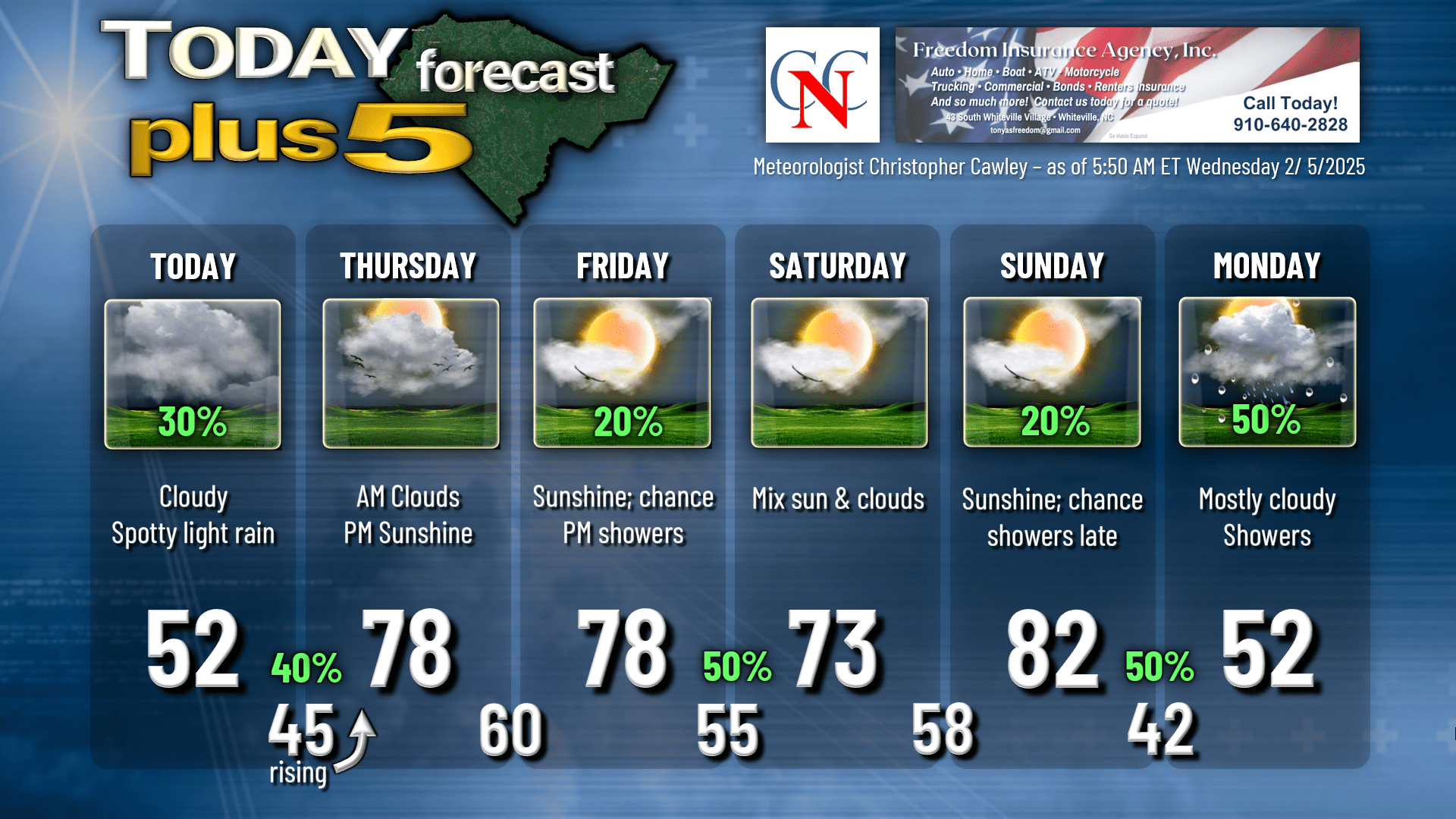
Mercy what a difference a day makes. Nearly 80 degrees yesterday… we’ll be lucky to get into the lower 50s today… and then back in the upper 70s on Thursday.
Why?
A series of frontal boundaries in an active “zonal” (west-to-east) weather pattern. One front dropped down from the north during the wee hours this morning. Our winds will be from the east-northeast today in a “wedge” setup (cold-air damming — see my posts on my FB page on how that works). This is caused by high pressure over New England. Clockwise wind flow around the high means our area is dead in line for that easterly flow off the cold Atlantic ocean. Meanwhile, the front that dropped to our south is likely to stall in a wavy kind of pattern from northern Georgia, to Savannah, and then curling back up along the NC coastline.
This afternoon, a little wave of low pressure is likely to spin up over central Georgia on this frontal boundary, and then lift northeast just off the NC coast tonight.
I expect spotty light rain to develop this afternoon in the chilly air mass trapped close to the surface. Warmer air will start to lift “up and over” the cold air this evening, resulting in a more steady light rain. This will continue as the low pressure wave lifts up the coast. The frontal boundaary also transitions to a warm front, and is “dragged” northward by the coastal low, and a much stronger low over the Ohio valley. We’re not going to see much in the way of rainfall. Perhaps one or two tenths of an inch at the most.
The rain should end after midnight and temperatures start to rise. Our lows will be experienced around midnight… with temperatures rising into the upper 50s/lower 60s at the bus stop Thursday morning.
The coastal low dissipates Thursday; the main low lifts north over the Great Lakes into southern Canada. I believe we’ll see clouds Thursday morning giving way to mostly sunny skies by lunchtime, with temperatures rocketing into the upper 70s during the afternoon.
Thursday night is quiet and unseasonably warm, and even somewhat humid (!!) with lows around 60.
Friday should be mostly sunny on the whole… but I’m still calling for the threat for showers during the afternoon as yet another cold front approaches. Highs should be in the upper 70s once again.
Cold front moves through Friday night with occasional showers and maybe some thunder. The front may stall in a way that’s similar to today’s front, but I think it will dissipate before any kind of wedge can set up on Saturday. Temperature forecast could be a little tricky Saturday, but I’m hedging my bets on warm temps with sunshine.
But wait… there’s more…
I’m fully confident that on Sunday we’ll be locked in a deep warm sector of a storm system moving eastward across southern Canada into northern New England. South to southwest winds from the tropics should easily bring our highs into the lower 80s Sunday afternoon.
Then *THE* cold front arrives, ushering in a wholescale change in the weather pattern that will likely last for the next 7-10 days, if not longer.
Showers and possible thunder a good bet Sunday evening and Sunday night with this front. Modeling shows the front slowing and stalling across the area going into Monday. If the front stalls to our south, our temps will be in the upper 40s to lower 50s with intervals of rain. If the front stalls just to our north, our highs on Monday could possibly reach the 60s with more “showery” conditions. Too soon to make any kind of call with confidence on this.
ALL guidance suggests to “colder” temperatures next week. In actuality, the temps should be around normal for this time of year, maybe a degree or two lower. The bigger story is the potential for significant, much-needed rainfall across the county next week. Ensemble modeling averages suggest that we could receive 1-3 inches of rain next week. That’s no guarantee, but when all 82 of the ensemble members say, “bruh, it’s gonna rain, lots,” I’m going with it.
(Oh, and in the case of “what a difference a day makes,” only 2 out of 82 members indicate frozen precip here next week… and both are less than half an inch. At this point the chances for another snow event here next week are almost zero.)
Here’s your Freedom Insurance Today-Plus-5 forecast for Columbus County.
That’s it for today my friends. Thank you for reading (and sharing!!) and for supporting ColumbusCountyNews.com I hope you have a fantastic day, and as always, take care.
~Meteorologist Christopher Cawley

