Greetings folks, welcome to your CCN Daily Weather Update for Saturday March 22, 2025.
This weather update is sponsored by Freedom Insurance of Whiteville. Protect what matters with Freedom Insurance. Life is full of surprises, but with Freedom Insurance, you’ll always be prepared. Whether it’s your home, car, business, or health, we provide customized coverage to keep you and your loved ones secure. Contact Freedom today at 910-640-2828!
STATISTICS FOR WHITEVILLE – Friday March 21, 2025.
High: 64.5°F at 5:06 PM (normal is 67)
Low: 43.1°F at 7:58 PM (normal is 42)
Precip: 0.00 in
View live, real-time weather data for Whiteville on my College Street Weather Station.
Here’s today’s Bottom Line
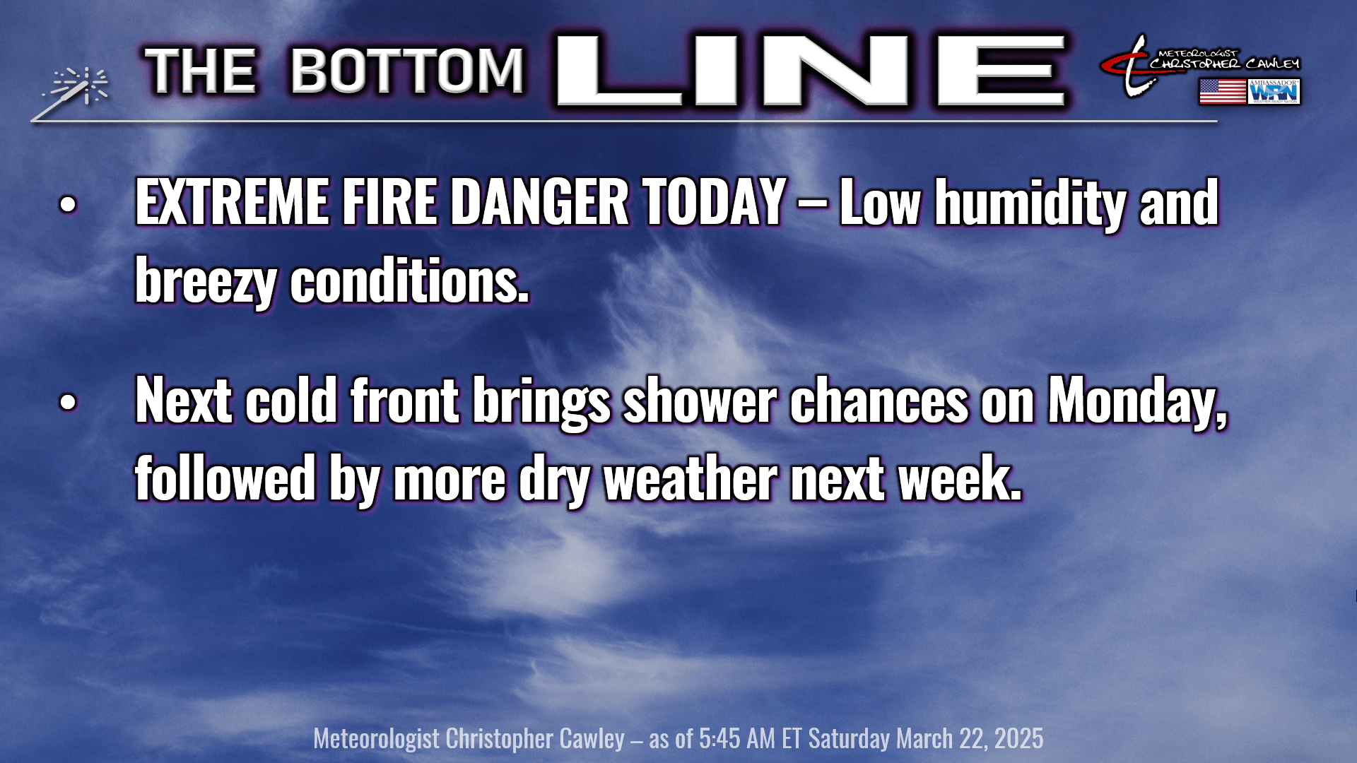

A Red Flag Warning is issued when critical fire weather conditions are happening or about to happen. It does not necessarily mean there is a fire, but that conditions will be very dry and breezy/windy. If a fire is present, it can very quickly become out of control.
In today’s case, relative humidity values will be between 20% and 30%, along with wind speeds in the 20- to 30-mph range. This will result in CRITICAL fire danger for today. Just a reminder, the NC Forestry Service has issued a STATEWIDE BURN BAN until further notice.
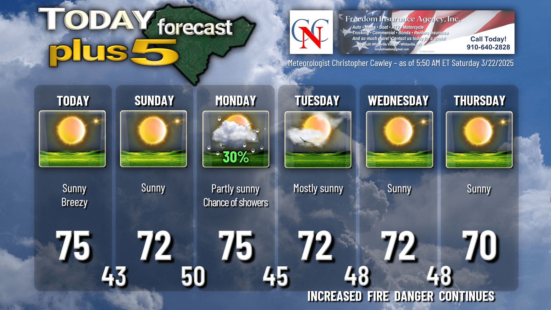
It’ll be a beautiful, albeit “yellow” and breezy day. Yall the pollen is insane… but not unusual for this time of year. It’ll be a great day to go out to the car show at the Veteran’s Memorial Park on 701 South.
A weak “cold front” (if you want to call it that) will sweep through the area tonight… but the only thing we’re going to notice is the lack of winds for Sunday. It’s still going to be very dry, with very low humidity values Sunday afternoon. So even though the winds will be light, the elevated fire danger will continue.
Sunday’s highs across the county should still be into the lower 70s … but if you’re traveling to the coast, from Wilmington to the Brunswick County beaches, highs will only be in the mid 60s thanks to a weak onshore flow.
High pressure pushes completely off the coast Sunday night and our next system begins to approach from the west. Winds become southerly and our lows early Monday will be around 50.
The only precipitation chances through the entire forecast period comes Monday afternoon as a shortwave and cold front moves through. Remember the few rain drops we received late Thursday? That’s similar to what we can expect on Monday. There is a very narrow window from about noon through suppertime on Monday where there could be enough moisture in the atmosphere to trigger a few rain showers. This front pushes off the coast by Monday night, ending the rain threat for the week.
Another cold front — entirely dry in passage — arrives Wednesday night into Thursday. This has a chance at being a fairly strong front (but again, completely dry). I’m going to be optimistic and put a 70 on the chart for Thursday but there’s a pretty good chance we’ll be lucky to reach the mid 60s. Minimum temperatures early Friday could be in the upper 30s with some patchy frost possible.
There will be an increased fire danger through the work week thanks to the dry weather. This second front coming through Wednesday into Thursday, could lead to more breezy/windy conditions. After the isolated frost threat early Friday, our temps jump back deep into the 70s (approaching 80) by next Saturday.
Here’s your Freedom Insurance Today-plus-Five forecast:
That will conclude today’s report. Thanks for reading, and as always, take care.
~Meteorologist Christopher Cawley