


CCN Weather Update for Saturday June 7, 2025.
This weather update is sponsored by Freedom Insurance of Whiteville. When severe weather strikes, with Freedom Insurance you will always be prepared. For home, car, boat, or whatever you need, Freedom can provide customized coverage to keep you and your family safe. Contact Freedom today at 910-640-2828!
Here’s today’s Bottom Line
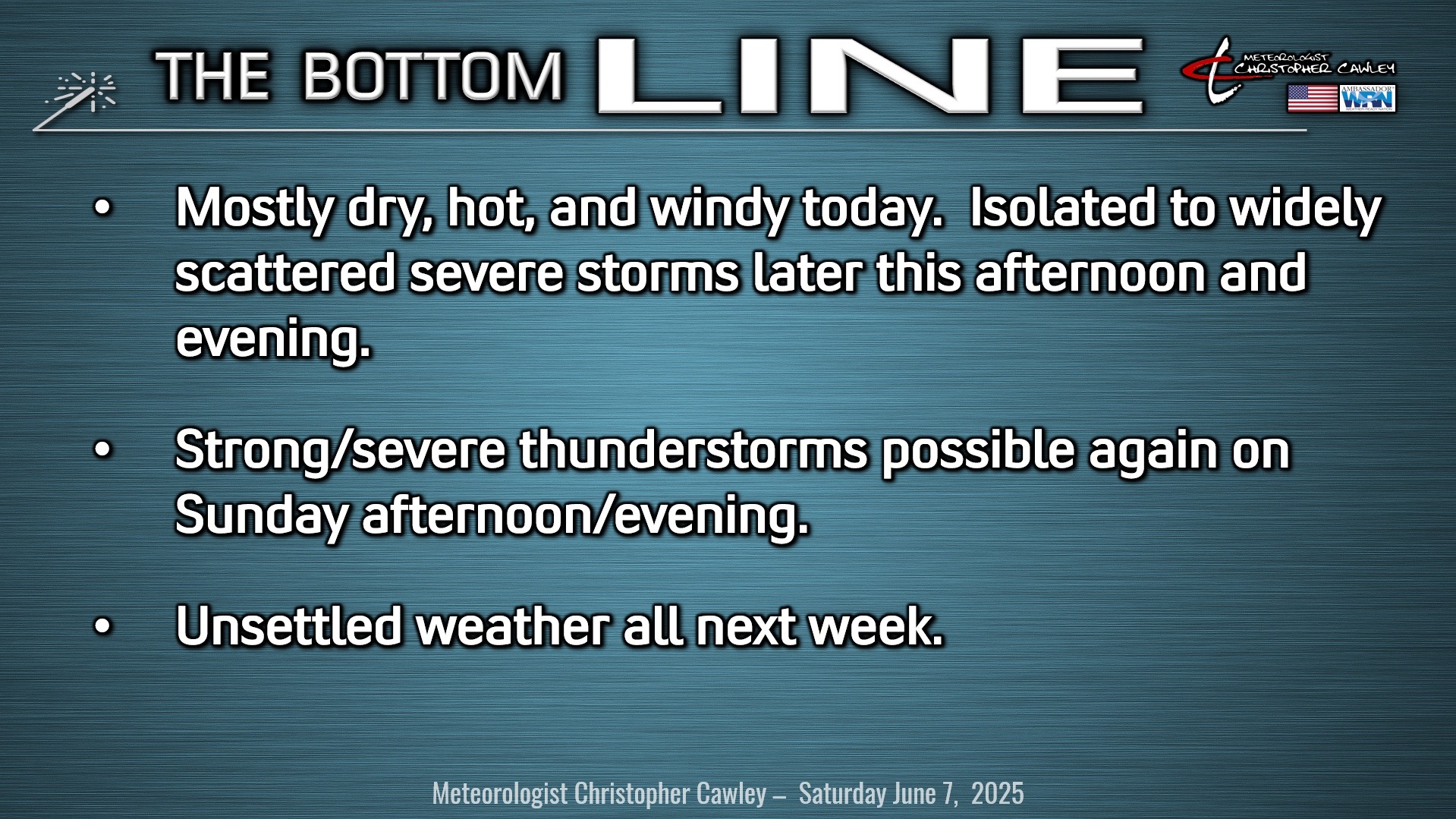
SEVERE THREAT TODAY: A shortwave trough, which is essentially a disturbance in the middle- and upper-levels of the atmosphere, will push a cold front toward Columbus County late this afternoon or this evening.
It’s going to be quite hot today, easily the hottest day of the season thus far, with our actual highs reaching the lower and middle 90s, and heat index values around the 100-degree mark.
It’s also going to become increasingly windy this afternoon.
For the most part today, we’ll be mostly sunny and dry. However, that approaching cold front will bring an increasing thunderstorm threat later this afternoon/evening. A cluster of strong storms is likely to develop over western and central NC and move to the east-southeast, but whether or not they survive the trek here remains a little uncertain.
All of the ingredients are in place. Instability numbers are going to be significant this afternoon, to put it mildly, with considerable shear in place as well. The environment will be quite supportive for severe thunderstorms. The primary threat will be that of damaging winds and wet downbursts, as well as large hail.
The Storm Prediction Center has our area under a level 2 out of 5 risk for severe weather. The SPC also outlines a 2% to 4% tornado risk for the county late this afternoon.
I do not believe this will be a widespread event. I believe the storms will be isolated to widely scattered in nature, but ANY storm that develops in this atmospheric environment could go from zero to 1,000 in a very quick fashion. It is very important that you maintain weather awareness late this afternoon into the evening.
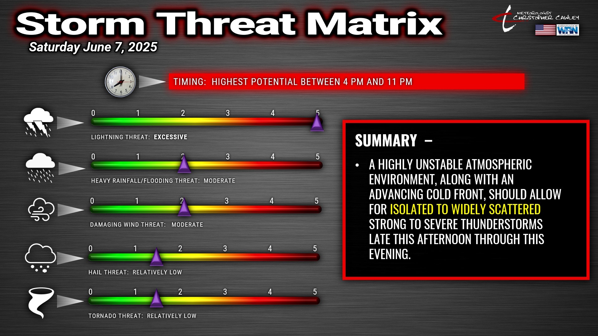
My threat matrix for today highlights LIGHTNING as a huge threat. Any storm that forms is likely to produce near-constant cloud to ground lightning. Lightning can, and does, strike up to 20 miles from the originating thunderstorm. If you can hear thunder, you are close enough to suffer a lightning strike, even if there’s blue sky overhead. I’m putting moderate for downpours and damaging wind, with relatively low hail and tornado threat. Any hail that occurs could be very large in nature.
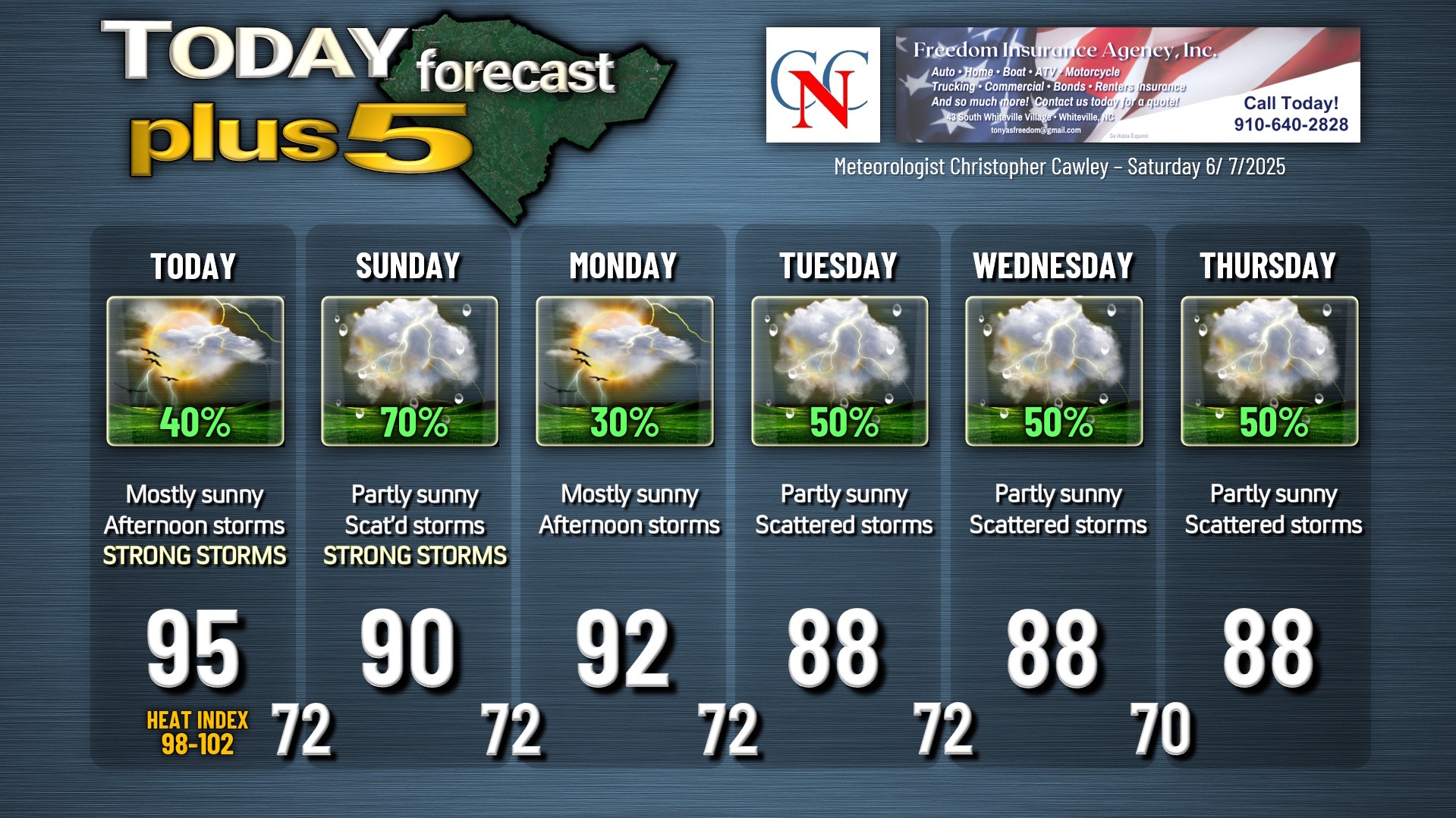
SUNDAY: There is a better chance for another round of strong to severe storms. This is thanks to yet another (and stronger) shortwave approaching and moving over the area. The SPC also has our area under a level 2 out of 5 risk. The primary risks for Sunday will be damaging wet downbursts and large hail. My threat matrix is virtually identical to that shown above for today, with the highest potential being after 2 PM.
Unsettled weather with occasional showers and thunderstorms is likely to last through the entire coming work week. My focus on today’s update is the severe threat today and tomorrow; I’ll worry about next week’s weather, next week.
SEVERE WEATHER REPORTING: The National Weather Service relies on what is known as “ground truth” as a part of the warning process. If you experience severe weather, such as damage from winds, flooding, hail, etc., you can contact the National Weather Service in Wilmington (which services Columbus County) by calling 800-697-3901. Be prepared to give an exact location and an accurate description. Hail should be reported comparing it to the size of common items, such as coins, peas, etc. “Marble” size hail is not a good report because marbles come in different sizes. Anyway, the meteorologist at the warning desk at NWS then takes your reports into consideration when establishing further warnings.
TROPICAL OUTLOOK: All remains quiet over the tropics.
Here is your Freedom Insurance Today-plus-Five Forecast:
–Meteorologist Christopher Cawley


