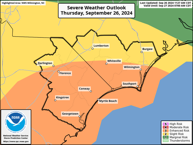

Southeastern North Carolina is now under an enhanced risk for tornadoes as powerful Hurricane Helene heads for the Florida panhandle.
The National Weather Service office in Wilmington in a 1 p.m. update increased the tornado risk here from Slight to Enhanced. While all of North Carolina is under a state of emergency, western counties are facing potentially catastrophic flooding. The southeastern part of the state will be targeted by the onshore winds from the eastern outer bands of Helene.
The chances of spinup tornados will increase throughout the afternoon, with the highest likelihood during the overnight hours.
Helene is expected to be a Category Three, potentially a Four, when it makes landfall today. The storm is already to be one of the most powerful in recent history to strike Florida. The radial arms of the hurricane are 300 miles long, so tropical effects will extend far out from the center for an extended period. Helene is expected to move north by northwest, with most if its effects being felt in the western parts of Alabama, Georgia and the Carolinas.
The hurricane is not expected to be a major rain event for Southeastern North Carolina. Area schools went to remote learning or cancelled classes for tomorrow due to the potential for high winds (see related story).
Monitor storm updates via the National Weather Service or local media outlets. Emergency officials said some social media pages dedicated to storms may have outdated or incorrect information. The Columbus County Sheriff’s Office app also offers text alerts with local weather warnings and advisories.