Welcome to the TGIF FRIDAY edition of the CCN Daily Weather update, wrapping up the month of February and meteorological winter.
This weather update is brought to you by our friends at Freedom Insurance in Whiteville. When severe weather strikes, have the peace of mind that your vehicles and property are well covered. Stop in today for a comprehensive policy quote that will fit all of your needs. Call us at 910-640-2828 or stop in at the south end Hills shopping plaza.
STATISTICS FOR WHITEVILLE – Thursday February 27, 2025.
High: 80.5°F at 1:22 PM (normal is 61)
Low: 51.9°F at 6:31 AM (normal is 36)
Precip: 0.04 in
Total precip for the month: 2.53 in
View live, real-time weather data for Whiteville on my College Street Weather Station.
Here’s your Bottom Line for today…
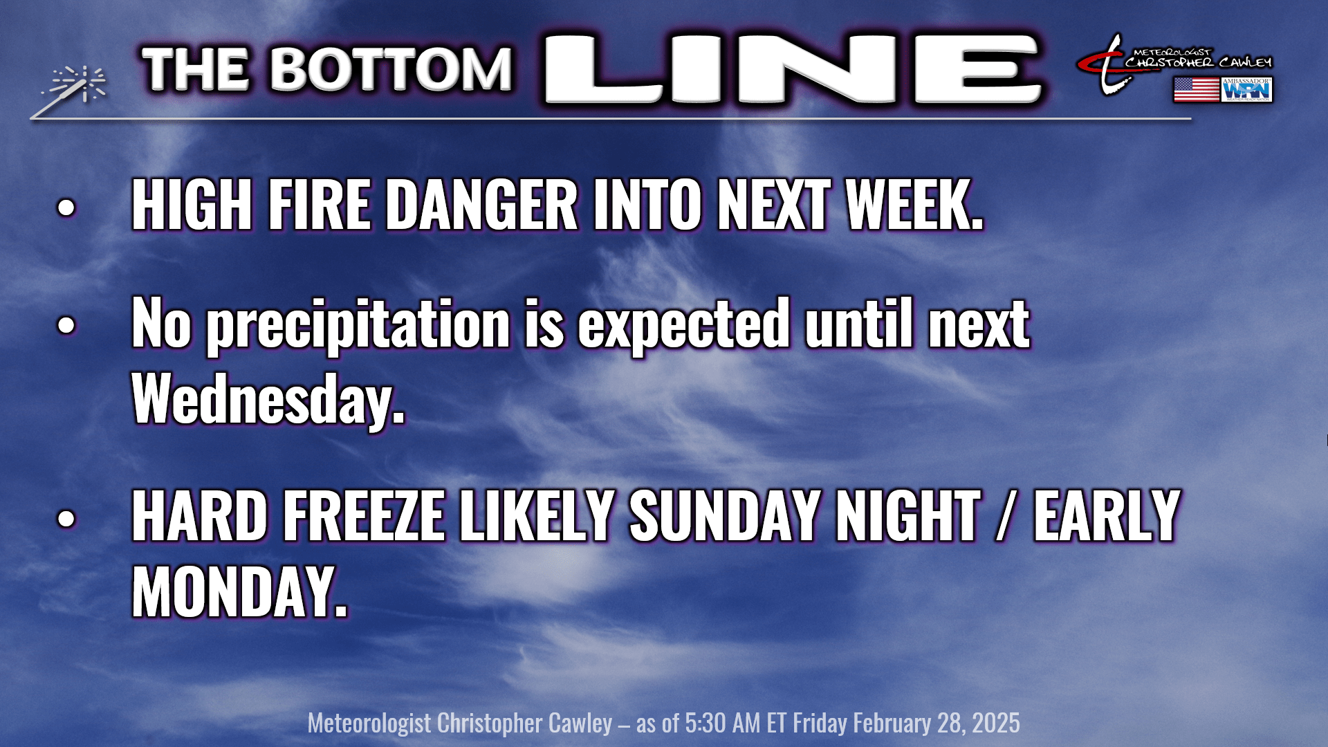

Very high fire danger remains in place today and tomorrow. The fire danger is expected to rise to EXTREME for Sunday through Tuesday. Even though temperatures on Sunday will be rather cold, and even though some of us had a nice little thunderstorm Thursday evening, soil conditions are very, very dry. Relative humidity values over the weekend and the first part of next week are likely to be in the 20%-30% range at times, so very high to extreme fire danger continues.
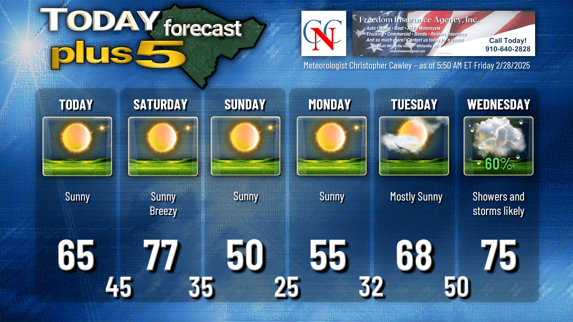
Dry high pressure will be in firm control of our weather through much of Saturday. Our highs today will average out in the mid 60s across the county. It’ll be a very nice day, but again, please, please, please avoid all burning. If you’re traveling closer to the beaches, temperatures will run probably 8 to 10 degrees cooler due to a healthy sea-breeze.
Southerly winds pick up on Saturday. It’ll be another dangerous fire weather day as winds gust 20-30 mph at times. This is all ahead of strong but moisture-starved cold front which will coast through Saturday night. Highs on Saturday reach the upper 70s to around 80…. and then temperatures absolutely tumble during the overnight, where we’ll be in the mid 30s by time you wake up on Sunday morning.
Sunday will feature January-like conditions with lots of sunshine but cold temperatures. Highs will struggle to reach 50 degrees. Sunday night becomes quite cold as temperatures drop well below freezing. My forecast will go slightly below the model blend averages — I’m putting a 25 on the chart for early Monday morning. Hard freeze will occur.
Monday’s temperatures continue below normal, but then a dramatic warm-up occurs on Tuesday as high pressure moves off the coast. A southerly flow pushes highs from the mid 50s on Monday to the upper 60s on Tuesday.
SEVERE WEATHER RISK ON WEDNESDAY
The “main event” of our forecast arrives on Wednesday. A powerful storm system develops over the central Plains on Tuesday and rapidly strengthens as it lifts toward the Great Lakes on Wednesday morning. A warm front will lift north over the area early Wednesday, which may bring some showers and thunderstorms… but it will bring dramatically warmer and possibly windy conditions by Wednesday afternoon. A very strong cold front then moves through late Wednesday afternoon or Wednesday night (there are some timing differences in the guidance) with rain and thunder.
There is a severe weather potential with this system… but there are some question-marks with this with regard to location of forcing and dynamics and timing of the frontal passage. At this time, the guidance suggests we will have a LOT of wind shear, but there is question of what instability builds during Wednesday afternoon. We have some time to watch this, so that’s what we’ll do… remain in “watchful waiting” mode.
We’ll clear out and return to more seasonable temps behind the front for the end of next week.
Next week is Severe Weather Awareness week, and I will be posting a series of videos on my Youtube channel and my socials talking about severe weather in the Carolinas. The 2025 Statewide Tornado Drill is scheduled for 9:30 AM on Wednesday March 5th.
Here’s your Freedom Insurance Today-Plus-5 forecast for Columbus County.
That’ll do it for today. Thanks for reading, and as always, take care!
~Meteorologist Christopher Cawley