

CCN Weather Update for the final day of July… Thursday July 31, 2025.
This weather update is sponsored by Freedom Insurance of Whiteville. No weather worries with Freedom Insurance. For home, car, boat, or whatever you need, Freedom can provide customized coverage to keep you and your family safe. Contact Freedom today at 910-640-2828!
Here’s today’s Bottom Line
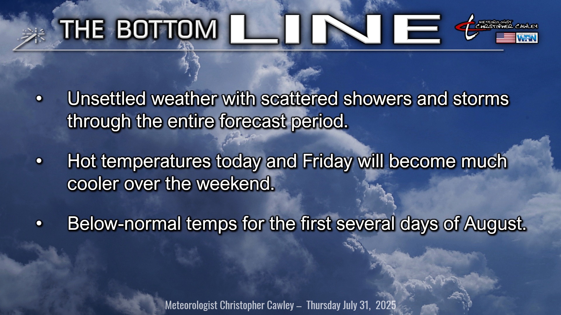
In a word: Unsettled.
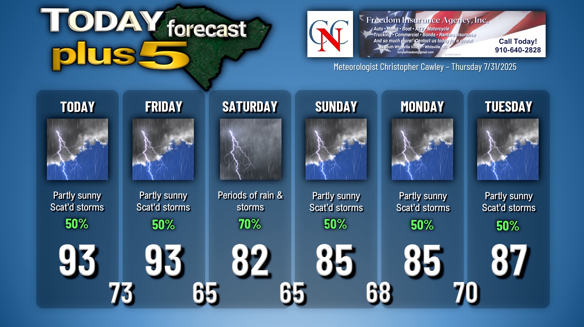
That’ll be the rule straight into next week with regards to our weather conditions. A slow-moving frontal system begins to approach our area today, which, when combined with multiple remnant outflow boundaries and the sea-breeze, will be the focus for thunderstorm activity. Storms should be scattered in nature, similar to yesterday, in a hit-or-miss type of scenario. Highs today will bump into the lower and middle 90s.
Much the same for Friday. The long-advertised cold front is taking it’s sweet time getting here and at this point I don’t believe it will cross the county until after dark Friday evening. We should start off the day with a mix of sunshine and clouds, but the threat for showers and thunderstorms once again increases as we move through the afternoon. There will be a bit of a renewed southerly push of very humid air… and while highs bump back into the lower 90s, heat index values might push advisory criteria at least for a few hours before storms start to fire up. I don’t know if NWS will issue an advisory on Friday but it’ll be the final day of significant heat.
As mentioned, the front finally inches its way across the area Friday night and stalls along or just south of the state line on Saturday. A wave of low pressure is likely to develop along the front and push eastward and off the coast Saturday afternoon and evening, bringing a round of rain and thunderstorms to the area. We could see some localized downpours Friday evening/overnight and once again Saturday afternoon/evening thanks to the front and the low pressure wave.
The frontal boundary continues to sag farther to the south Saturday night into Sunday and Monday, with repeated waves of low pressure riding along it. These waves of low pressure, along with a bit of a high pressure wedge pattern (extremely unusual for early August) will keep the threat for mainly afternoon and evening showers and thunderstorms in our forecast well into next week. Temperatures will drop several degrees below seasonal normal values (we should be right around 90 for highs on the 1st of August) this weekend before slowly pushing back up toward climatology by the middle and latter half of next week.
One might ask… could any of these waves of low pressure develop into something tropical once they push offshore? While the answer is never “no,” it’s highly unlikely at this time. These lows are more-or-less just shortwaves running along the frontal boundary and I don’t see them becoming anything interesting.
As far as rainfall amounts, they could be quite robust depending on where showers and storms set up. The National Blend of Models has between 2 and 4 inches of rain painted across southeast NC (including Columbus County) from today through August 5th. Amounts of 3-5 inches are possible from Myrtle Beach northward through Brunswick and New Hanover counties. The rainfall amounts will vary considerably, again depending on where the rain and storms become established.
Any thunderstorm, at any given location and time, could produce intense rainfall leading to isolated, short-term flooding of poor-drainage and low-lying areas. This is from today straight through at least next Tuesday.
TROPICAL OUTLOOK: There is nothing of interest or potential development in the tropics at this time. The GFS model wants to spin something up along the west coast of Florida during the August 9-11 timeframe, but that’s just too far out in time to give any consideration.
Here is your Freedom Insurance Today-plus-Five Forecast:
–Meteorologist Christopher Cawley


