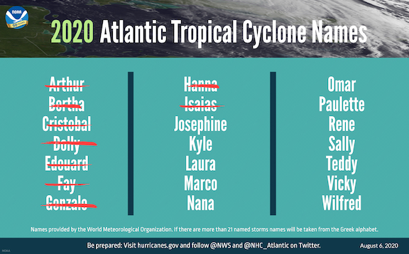
The updated hurricane forecast Thursday from the National Oceanic and Atmospheric Administration (NOAA) increased the anticipated number of storms in the Atlantic Basin.
The estimated number of named storms increased from 12 to a range of 19-25, with seven to eleven major hurricanes this year. The prediction includes the nine storms that have already come and gone, including Isaias,
“This year, we expect more, stronger, and longer-lived storms than average, and our predicted ACE (Accumulated Cyclone Energy)
range extends well above NOAA’s threshold for an extremely active season,” said Gerry Bell, Ph.D., lead seasonal hurricane forecaster at NOAA’s Climate Prediction Center. ACE data is just one set of data that helps forecasters predict tropical weather, and this year’s ACE data has increased the chances of an over-active season to 85 percent.
NOAA’s hurricane season outlook is for overall seasonal activity and is not a landfall forecast. Landfalls are largely determined by short-term weather patterns, which are only predictable within about a week of a storm potentially reaching a coastline.
Historically, Bell said, only two named storms form on average by early August, and the ninth named storm typically does not form until Oct. 4. An average season produces 12 named storms, including six hurricanes, of which three become major hurricanes (Category 3, 4, or 5).
Those numbers are out the window for this year, Bell explained.
“The 2020 Atlantic hurricane season has been off to a rapid pace with a record-setting nine named storms so far and has the potential to be one of the busiest on record,” he said in a press conference Thursday.
A number of meteorological events are contributing to the anticipated increase in storms, ranging from an active monsoon in Africa to warmer water in the Atlantic and Caribbean and a lack of wind patterns that tend to cause “shear,” breaking up hurricanes before they reach land.
NOAA’s National Hurricane Center provides tropical weather outlooks out to five days in advance, provides track and intensity forecasts for individual storms, and issues watches and warnings for specific tropical storms, hurricanes and the associated storm surge.
NOAA’s hurricane season outlook is for overall seasonal activity and is not a landfall forecast. Landfalls are largely determined by short-term weather patterns, which are only predictable within about a week of a storm potentially reaching a coastline.
Bell said that 2020 could be one of the most active seasons on record in the United States, although it’s entirely possible that none of the storms every make landfall here.


