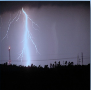
Tornadoes, hail, severe thunderstorms and high winds are likely across Southeastern North Carolina Thursday afternoon, according to the National Weather Service.
The National Severe Storm Prediction Center (SPC) has upgraded all of the area to a moderate risk for severe weather. Moderate is the next to highest level used by the SPC.
Some of the winds could reach tropical storm to hurricane force, with stronger gusts. The storm is not expected to be a significant rain event, but some ponding on roads and nuisance flooding could occur.
Widespread, intense and extended thunderstorms are anticipated across the Columbus County area. Large damaging hail is also expected.
The storms are expected to move into the area early Thursday afternoon, and continue into the overnight hours, according to the Wilmington office of the National Weather Service. The most severe impacts should begin around 1 p.m.
Of gravest concern, according to the NWS, is the possibility of tornadoes. The weather system bears some resemblance to the deadly April 2011 tornadic system that caused some damage here and killed two people in Bladen County.
Due to the threat of severe weather tomorrow, all Whiteville City Schools will dismiss at 1 p.m. tomorrow. All after school events are canceled. Bladen and Brunswick schools have cancelled in-person classes for tomorrow due to the storm threat. Columbus County Schools also postponed Thursday’s District Strategic meeting for West Columbus, rescheduling the meeting for Monday at 6 p.m.
Emergency officials are urging residents to make sure anything that could become a flying hazard is tied down and secured before tomorrow morning.
State Emergency Management officials also offered the following suggestions:
Families should identify a safe place to take cover in their homes in the event of a tornado warning. That should be an interior room on the home’s lowest level, away from doors or windows. Everyone in the family should know the plan, and be prepared to act on it if a tornado warning is issued for your area.
- Report power outages immediately to the local electric company. Don’t rely on your neighbors to report your outage.
- Stay away from downed power lines, flooded areas and debris. Treat all fallen wires and anything touching them as though they are energized. Immediately report downed lines to your local electric company.
- Keep freezer and refrigerator doors closed. Food will stay frozen for 36 to 48 hours in a fully loaded freezer if you keep the door closed. A half-full freezer will generally keep food frozen for 24 hours.
- Pack refrigerated items, such as milk, other dairy products, meat, fish, eggs, gravy and spoilable leftovers into a cooler surrounded by ice.
- Follow safe operating procedures for generators. Never operate one inside your home or in an enclosed space, such as a garage.
- If using portable stoves, kerosene heaters, or lanterns, make sure that the area is sufficiently ventilated.
The NWS is scheduled to release updated information Thursday morning. We’ll have that information here and on WTXY 103.9 FM/AM 1540.