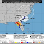

Tropical Storm Debby is expected to reach hurricane status today (Sunday), and could bring what officials are calling historic rainfall to North and South Carolina later this week.
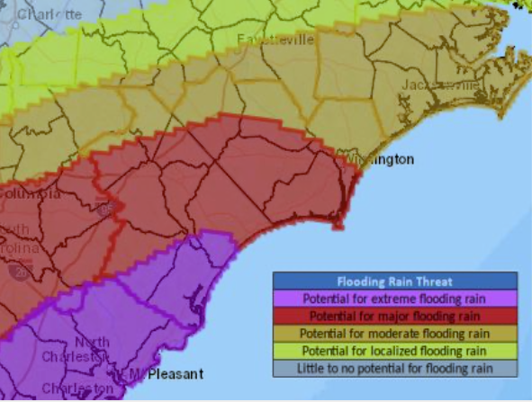
The National Weather Service (NWS) said in a briefing today that up to a foot of rain is possible in some areas of upper South Carolina and southeastern North Carolina. The NWS said in a briefing this weekend that the rainfall could reach “historic” proportions in South Carolina, with the potential for record-breaking rainfall here.
“Debby is forecast to slow down considerably near the Georgia/South Carolina coast during this week,” said Steven Pfaff of the NWS in an email briefing Sunday morning. “The very slow progression will result in significant rainfall and the potential for areas of flash flooding.
Much uncertainty exists with the longer range track of the storm, given the storm will become situated in a prolonged area of weak steering.”
Preparations are underway in flood-weary Columbus, where Tropical Storm Idalia flooded downtown Whiteville less than a year ago. City officials and some downtown business owners were wasting no time preparing for the storm, and a potentially heavy band of tropical rain that will precede Debby’s visit.
Teresa Smith of Columbus County Emergency Management said county staff has been briefed, but no emergency measures have been taken yet. Staff is monitoring the storm, she said, and sharing updates as the NWS Wilmington office provides new information.
Stephanie Miller of Columbus Regional Health Systems said the hospital is in contact with the county and NWS
“If you live in a flood-prone area, you need to be making plans now,” Whiteville Emergency Services Director Hal Lowder said Saturday. “Avoid misinformation. Get your news and updates from responsible sources like the National Weather Service.”
City crews have shifted over to storm preparations, Lowder said. All available drains will be cleared before the storm. Crews constantly work on keeping stormwater pathway clear, he explained, “but it gets a little more urgent” when a severe weather event is possible.
“Folks can help by not putting debris in the gutter, where it can wash into drains,” Lowder said.
Lowder said officials in the city will be aggressively enforcing “no drive” zones in flooded areas if streets have to be barricaded due to flooding.
“We say it all the time – don’t drive through floodwaters,” Lowder said. “People do it anyway, and you’re endangering your own life, the lives of anyone with you, and our first responders.”
Some properties in downtown Whiteville as well as Chadbourn sustained damages due to wakes caused by vehicles driving through Idalia’s flooding.
“If it’s flooded, nothing is going to be open,” Lowder said. “There is absolutely no reason to drive through floodwaters. A few inches will float a car out of control. You don’t know if a road has been washed out, or what is under the water.
“If a road is blocked – there’s no reason to be driving on it ,” Lowder said.
Additional rain will be moving into the area through Wednesday from a system to the west that is not directly related to Debby. While the forecast is subject to change, Debby’s effects are expected to move into the area Wednesday into Thursday.