DEEP FREEZE COMING AFTER THANKSGIVING.
The coldest air of the season to date is staged and set to invade the coastal Carolinas right after Thanksgiving.
We are looking at a deep, hard freeze… especially the mornings of Sunday-Wednesday, December 1-4.
Here’s how this is all going to play out.
Monday and Tuesday (November 25-26): The first part of this week will be unseasonably warm with highs jumping well into the 70s on Monday and Tuesday. There will be the chance for showers Tuesday afternoon as a cold front moves across the area. This front will be attached to a strong area of low pressure just north of the Great Lakes. The front should drag through Tuesday afternoon. I don’t believe there will be a lot of moisture for the front to work with, so we should be looking at widely scattered showers at worst.
Wednesday (November 27): High pressure builds in on Wednesday from the northwest bringing slightly cooler and drier air to the area. We should still be quite a bit above normal for our highs — mid to upper 60s. No local travel concerns for the biggest travel day of the year.
Meanwhile, a complex area of low pressure will be getting its act together over Oklahoma and Texas, with additional low centers over New Mexico and Colorado. A cold front … with an attitude … will begin to take shape.
Thanksgiving: The aforementioned storm conglomerate takes dead aim on our area. Turkey Day should start off dry… but the threat for showers and thunderstorms increases through the afternoon hours. Thunderstorms are possible due to some mid-level instability that is being shown by the modeling. I wouldn’t be surprised to see a low-end severe weather risk during the late afternoon on Thanksgiving if enough instability can develop.
The cold front moves through Thursday night. Breezy to windy conditions with widespread showers will accompany the front, and again, some thunder is possible Thursday evening.
Black Friday: Showers may linger early in the day, especially along the coast, but we should see increasing sunshine through the afternoon with breezy conditions. Our high temperatures will likely be reached early in the day with a temps falling during the afternoon.
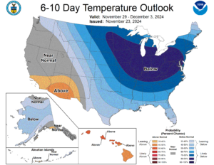
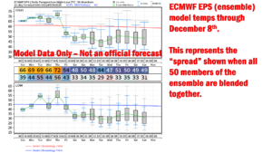
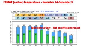
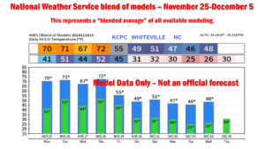
Friday night and Saturday the deep freeze begins. Details are a little bit sketchy right now as we’re talking 7 days out, but modeling is in firm agreement that a deep freeze will commence. Friday night should drop to the upper 20s/around 30, with highs on Saturday struggling to reach 50. High temperatures after that … Sunday through at least Wednesday … will likely be in the 40s with morning lows in the lower to middle 20s. It appears right now that Tuesday will be the peak of the cold snap… the latest European (main ECMWF) is advertising highs in the 30s with lows dipping to the lower 20s. I think that might be a bit extreme, but you get the idea.
There is a slight potential for breezy conditions at least during the first part of this cold snap… Saturday and Sunday. This could lead to wind chill values in the upper single digits or perhaps lower teens during the morning hours.
Snow chances? Not zero! While the center of the Arctic blast will be thanks to strong high pressure, a weak system known as an “Alberta Clipper” may impact portions of the Great Lakes into the northeast. This will a) reinforce the cold air in place here, and b) lead to the potential — potential — potential (far, FAR from a certainty) that we may see a few snowflakes even here in southeast NC. The European model ensemble snow grid shows that 9 out of the 50 model runs paints a little bit of snow here Monday night into Tuesday. The GEFS (GFS ensembles) aren’t really on board — just one of out the 30 runs show a trace of snowfall about the same time frame. So I doubt it… highly doubt it… but there’s a chance.
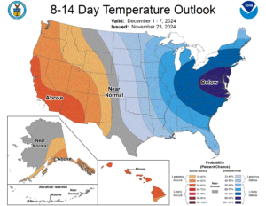
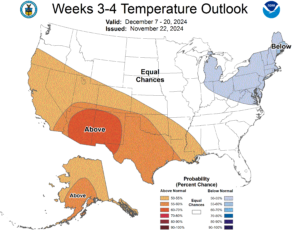
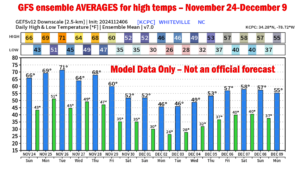
The cold air looks to be locked in place through at least December 7-8 before we start to modify toward more seasonable normal values by the 10th.
Normal (average) high temps for the first week or so in December run from the upper 50s for inland locations to around 60 at the beaches, with average lows in the upper 30s inland to around 40/lower 40s at the beaches. We won’t experience temps at these levels until at least December 10th, possibly later.
Make sure your home, business, and vehicle are ready for the cold temperatures. Make sure your tires are inflated to the proper level, that your coolant (antifreeze) is full, and keep at least half a tank of gas to prevent moisture build-up in the gas tank. Make sure outdoor pipes are protected and covered, garden hoses are disconnected, and that your heating system is in good running order.
Please make sure your kiddos are dressed appropriately when they return to school after the Thanksgiving break. Temperatures at the bus stops will be deep in the 20s.
Graphics attached are all labeled and include the model temperatures — these are models, not specific forecast. I have also attached the CPC outlooks for the first part of December.
Thanks for reading, and take care!

