Good evening, here’s your weather update for Tuesday November 5, 2024.
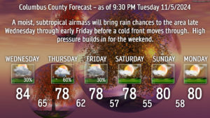
We’ll have rain showers developing later Wednesday afternoon, peaking Wednesday night and Thursday, tapering off Thursday night. This is thanks to a subtropical air mass pushing onshore. The air mass becomes southwesterly in the upper atmosphere, and this will bring in some moisture removed from Hurricane Rafael.
The amount of rainfall, as shown by modeling, generally puts Columbus County into an area of between half an inch and 1.5 inches late Wednesday into early Friday. Regardless of what we get, every little bit helps ease the dry conditions, and we need it.
After this system, a cold front crosses the area Friday. Following that, high pressure pushes back in bringing dry weather and a continuation of unseasonably warm temps.

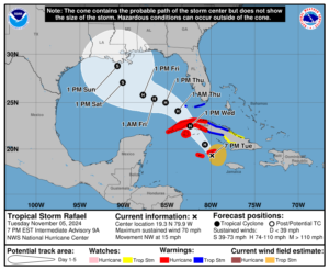
Tropics: Now-hurricane Rafael continues a northwesterly track in the Caribbean. The latest NHC forecast shows Rafael crossing the Cuba peninsula Wednesday, and then moving into the Gulf of Mexico Thursday and Friday. Modeling still shows a good deal of shear and dry air along the Gulf coast by the weekend, which should work to weaken Rafael before he makes landfall Sunday afternoon, likely somewhere along the Louisiana coast (although the cone of uncertainty is large).
As I said, some upper-level moisture from Rafael will connect with the subtropical air mass and work to enhance some of the rainfall we’re likely to receive this week.
That’ll do it for tonight, folks. Thank you for reading, and take care.


