Meteorologist Christopher Cawley here with your weather update for Monday December 9, 2024.
Keep an umbrella handy for today through Wednesday as the chances are fairly certain we will receive some much-needed rainfall across the area.
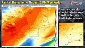
We’re currently listed as being under a “moderate drought” by the US Drought Monitor. The rain we are set to receive will certainly help put a dent in this. A series of weather systems will move over the area and we stand to receive 1-2 inches of rain now through Wednesday afternoon.
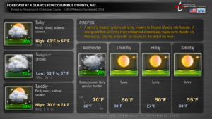
TODAY (Monday): We’re not looking at a lot of rain today. A middle-level system will lift northeast over the Carolinas today. An area of light rain is possible/probable this morning. This likely comes to an end late this morning and we should be dry into the afternoon hours. Showers develop once again during the mid-afternoon (according to the latest HRRR modeling).
TONIGHT THROUGH TUESDAY: An increasingly moist southwesterly wind flow will allow several “shortwaves” (basically weather systems occurring in the middle to upper levels of the atmosphere) to move from southwest to northeast over the Carolinas. This keeps occasional showers in the forecast through about lunchtime on Tuesday. It won’t be raining everywhere all the time, and there will, of course, be a few areas that receive little to nothing. Tuesday afternoon will feature some sunshine and our temps will jump well into the 70s on southerly winds.
TUESDAY NIGHT INTO WEDNESDAY … and a little bit of SCIENCE: The multitude of “shortwaves” kind of conglomerate together (or “phase” for all you weather geeks out there), and a strong cold front pushes across the area. This is likely to bring widespread showers to the area, with some potentially heavy rain.
We also have the potential for thunderstorms… and a low-end severe risk may develop on Wednesday. The atmospheric environment will be known as a “high-shear, low-CAPE” environment. This is a fairly common occurrence over the Carolinas during the cool season, when strong cold fronts move through the area. Severe weather in these environments usually amounts to “gusty showers” with very little, if any, lightning/thunder. A forecasting difficulty with these environments is the threat for tornado development. Shear represents the change of wind speed and/or direction with height (from the ground upwards). High shear can “tilt” a thunderstorm’s updraft in such a manner that the updraft and downdraft remain separate from one another. In the summertime, high shear values are typically accompanied by high levels of instability (also known as CAPE). In the cool season, and during Wednesday’s event, the instability will be extremely low, if any exists at all. This means that there is low energy in the atmosphere for thunderstorm development. Therefore, the high shear can allow rotating air to be ingested into whatever updraft exists, which can lead to isolated, weak tornadoes.
In digesting the numbers for Wednesday, weak lapse rates (the rate at which temperature changes with altitude in the atmosphere) and increasingly widespread rain will limit instability, but there may be some potential for “low-topped” showers with gusty winds to spread across the county. Shear values do look robust. IF … IF a severe weather threat evolves, it would consist of a broken-segment line moving west to east across the area during the late morning or early- to mid-afternoon hours, and the primary threat would be that of an isolated weak tornado. I’m not really on board with a severe risk but there’s still some time to pinpoint the specifics. The gist of all of this is that Wednesday could be a rainy and breezy day.
Rainfall totals across the County should be between 1 and 2 inches. Some areas may pick up more rain, while other areas may get less. MOST of this rain will occur late Tuesday through early Wednesday afternoon.
After the cold front passage, another blast of Arctic air invades the area, but I don’t think it will be as significant as the last two cold snaps… but we will be below normal for several days.
WOLFPACK ROUND 5 in Elizabeth City, NC – the early call is for clear skies with temperatures falling into the mid 30s.
Ok friends, that’ll wrap it up for this weather update. Stay dry, thanks for reading, and take care!


