Hi everyone, Meteorologist Christopher Cawley here with your Saturday morning CCN Weather Update.
In today’s report we’ll talk about the unseasonable warmth we’ll experience through New Year’s Eve, the severe weather threat for tomorrow (Sunday), and the big-time cool-down that is likely to take place after the first of the year.
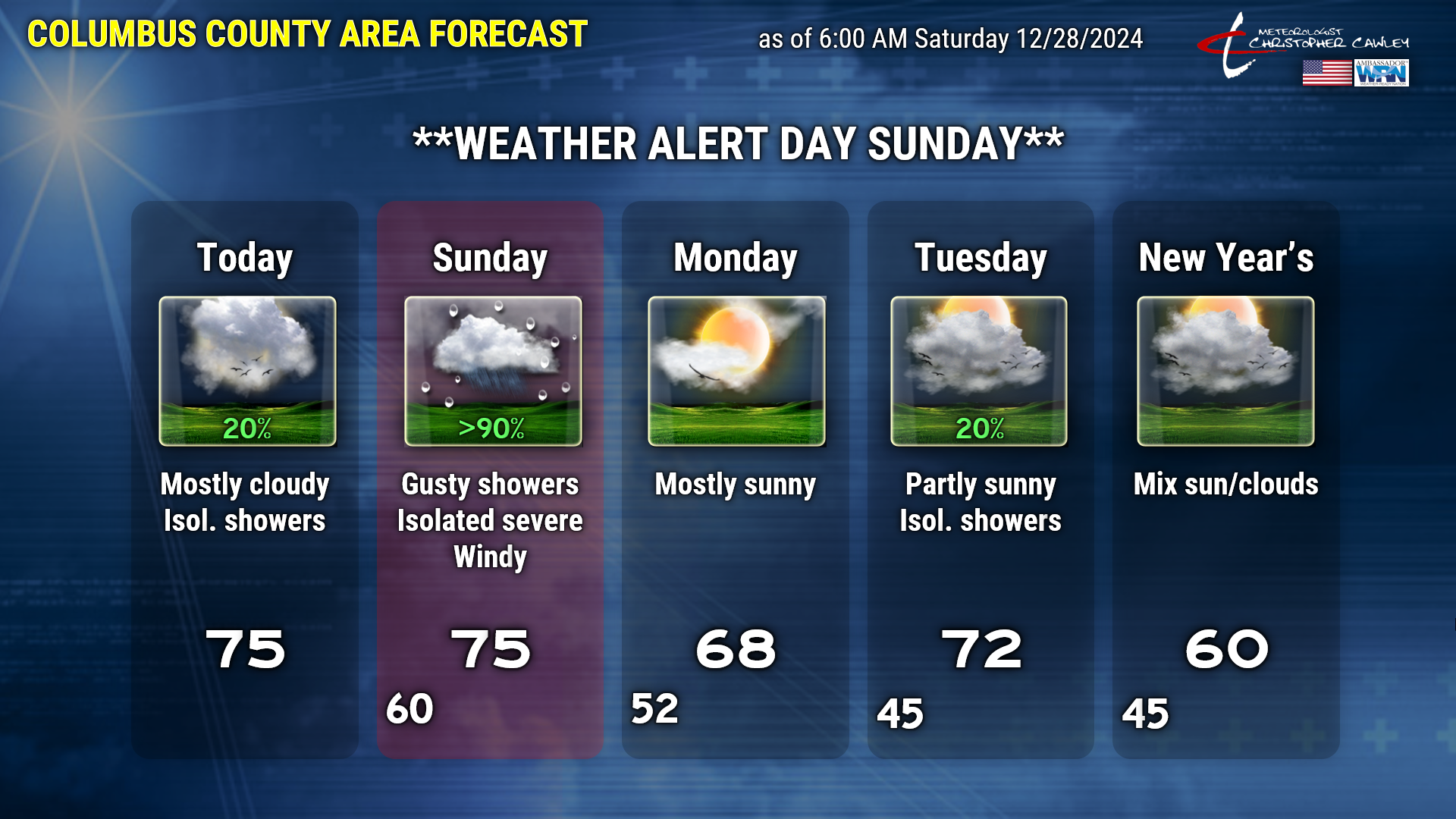
TODAY AND TONIGHT: Open up the windows today, it’s going to be WARM. And somewhat on the humid side. I didn’t think I’d be writing that on December 28th, but here we are.
We’re starting off our day with some low clouds, which should gradually erode this morning in a warm southerly flow. I expect our skies to remain mostly cloudy, though, with a mix of middle and upper level clouds. We should still see some breaks of sunshine from time to time. In this warm flow, our temps punch deep into the 70s across the county. If you’re traveling out to the coast, temps will be a few ticks cooler, and if you’re headed west, temps will be cooler west of I-95. I can’t rule out a few isolated showers as well.
The southerly flow only becomes more robust tonight. Our lows will be warmer than our normal highs … I think we’ll stay around 60 tonight. Increasing chances for showers as well.
SUNDAY — WEATHER ALERT DAY — SEVERE WEATHER POTENTIAL: A STRONG southwest flow increases in the middle and upper levels of the atmosphere ahead of a “trough” (essentially a “disturbance” in the atmosphere). This trough works to lift a warm front northward through the area… and then will push a strong cold front across the county late Sunday afternoon or early evening.
There is a severe weather threat Sunday afternoon in the form of damaging winds and isolated tornadoes. Modeling suggests a squall line comes together and moves across the county during the mid- to late-afternoon time period. There is a little disagreement in the timing when looking at the shorter-range modeling, and this will hopefully get ironed out a little more by this evening. I think the “prime time” for severe weather will occur between 1 PM and 6 PM, but again, that window could shorten as I look at future model runs. I will post updates on my Facebook page with those details.
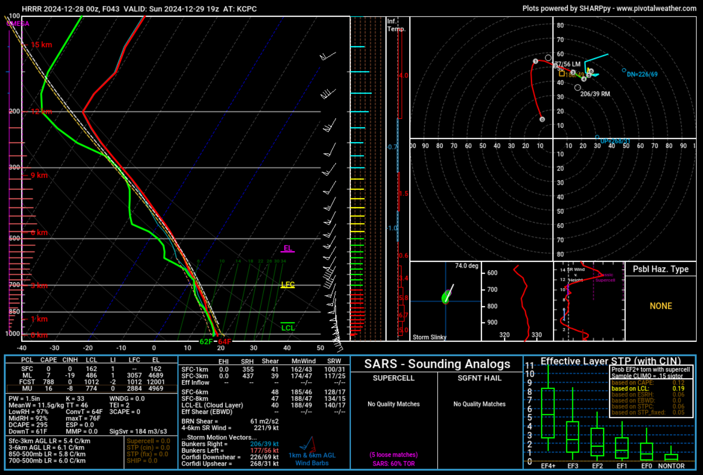
Factors involved with the severe weather threat are those typical with winter-season events. I don’t expect there to be a lot of lightning/thunder, if any at all. The model forecast sounding, also known as a Skew-T/log-P chart, just doesn’t show a “dynamic” severe weather picture. For severe weather we need shear, instability, and lift. We have plenty of lift, with the frontal boundary. The shear parameters in this event are in the 40 to 60-knot range on Sunday afternoon, which are somewhat elevated, but not eye-popping.
As far as instability goes, the sounding does show some “elevated instability,” meaning the most unstable air (if you want to call it that) will be above 8,000 to 10,000 feet off the ground. I say “instability” loosely here, I’m practically zooming in 500% on the image just to find it. IF there are any rumbles of thunder, they should be “high” up and quite faint. There’s a very stable layer of air between 1,000 and 6,000 feet thanks to our closeness to the ocean, and I think this is what’s going to prevent us from really getting anything reaching severe limits.
Here’s a screenshot of the HRRR model sounding for all you weather nerds out there:
I wouldn’t be surprised to see 35-45 mph wind gusts “pushed down” to the surface as a semi-broken or broken line of convection approaches (see below), with perhaps a few gusts approaching 50 mph right as the line is at our doorstep.
The NWS Storm Prediction Center has the western half of Columbus County shaded under the level 2 out of 5 risk for severe weather on Sunday. This will be updated throughout the day today, and I’ll post those updates on the FB page.
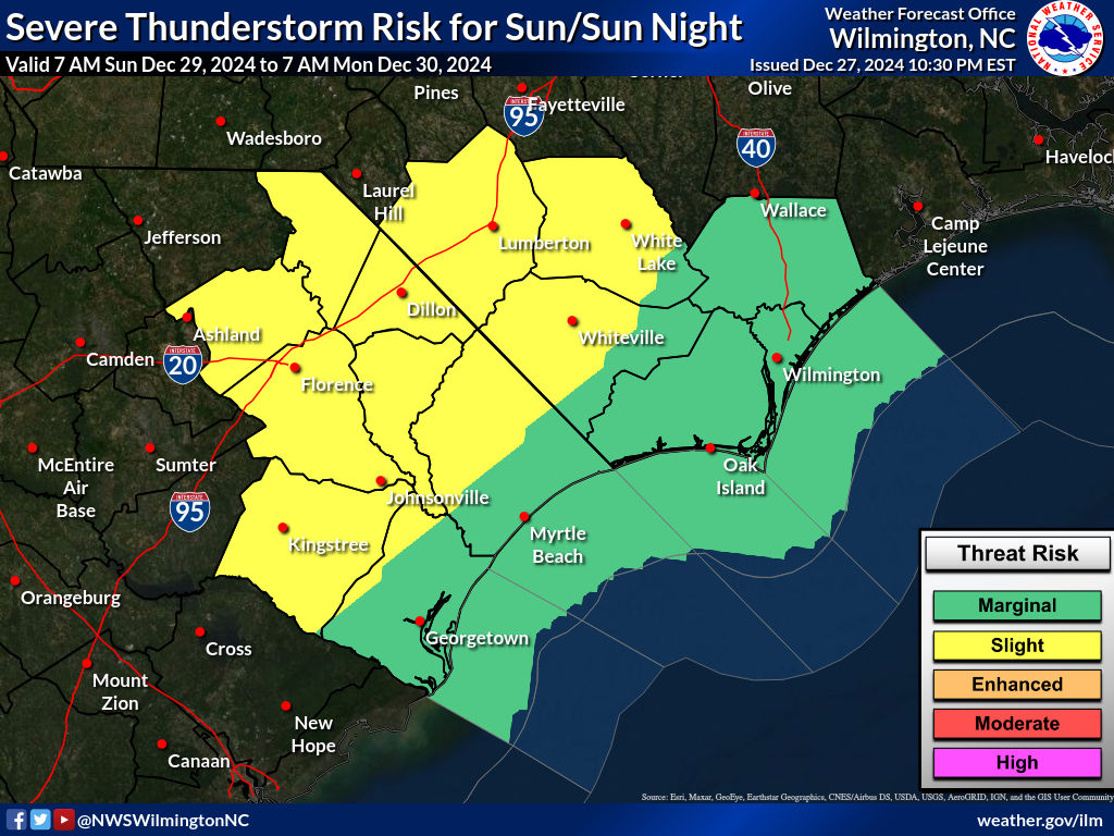
The primary threat, again, will be ISOLATED damaging wind gusts and an ISOLATED tornado. And honestly, I think that’s a stretch.
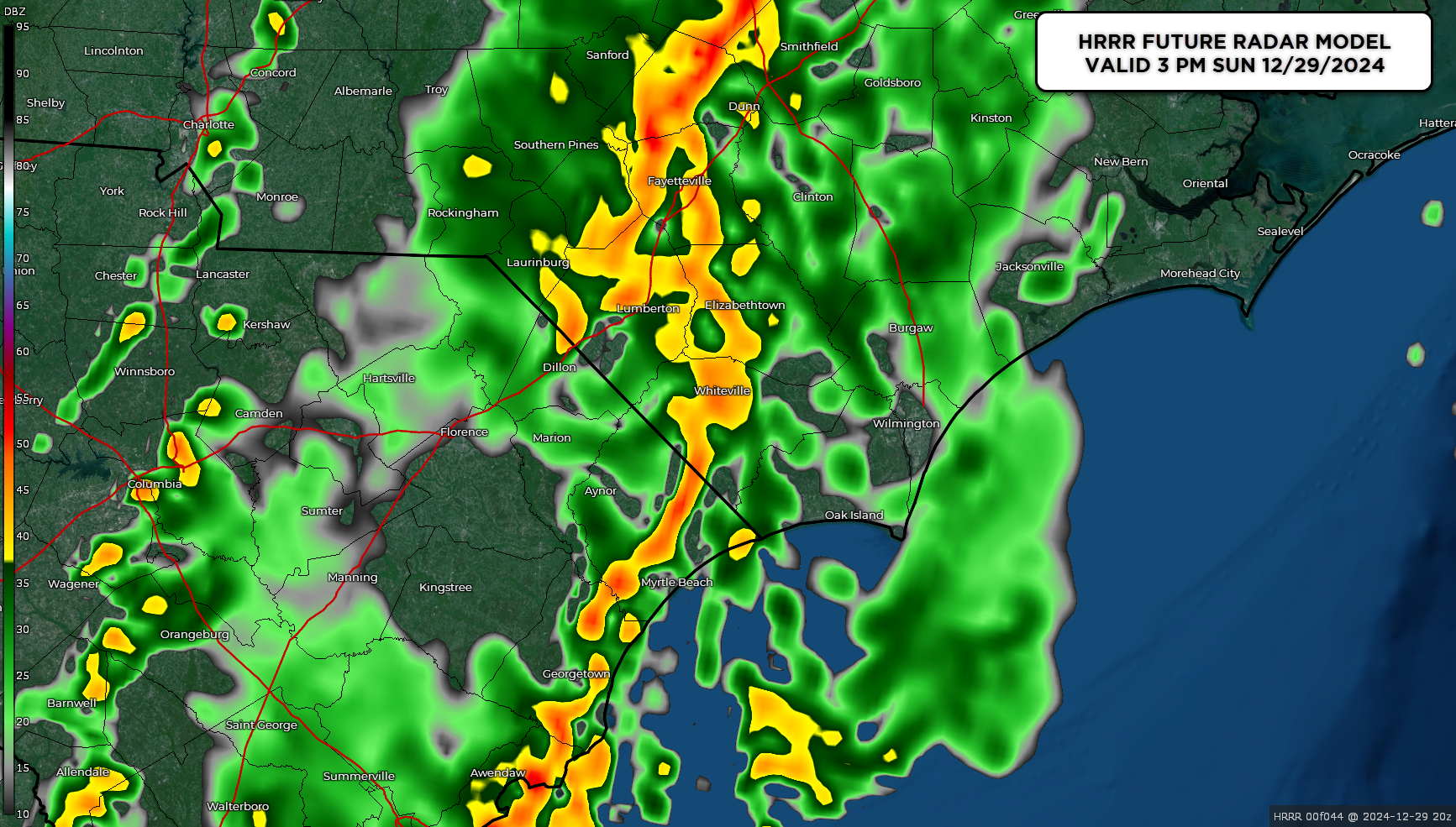
Below is the future radar model for 3 PM on Sunday afternoon — this is the HRRR model. I believe this is illustrating a “worst case scenario.” I expect more of a broken line of “convective showers” (heavy showers with gusty winds, but little to no thunder or lightning). The NAM3k is lagging a few hours behind, and shows a more broken/segmented line of showers moving through between 3 and 5 PM. Don’t focus specifically on the “time” right now as this will be modified/updated, probably by the time you read this. Just be prepared for some rough weather to blow through here Sunday afternoon.
Breezy conditions are also likely on Sunday even away from the squall line. That robust southwesterly flow ahead of the front will feature winds gusting in the 30-40 mph range at times, especially from late Sunday morning through the afternoon. The latest short-run modeling has a peak wind gust for Whiteville of 43 mph Sunday afternoon, and that does not include what may occur when the front passes by.
Rainfall looks to be between three quarters of an inch to around one inch.
So for Sunday, make plans to just stay indoors and enjoy some NFL action.
It’s all a memory by Sunday night as the front clears the coast. The winds will likely stay elevated in the 25-35 mph range through Sunday night.
MONDAY INTO NEW YEAR’S EVE: A west-to-east wind flow will take shape over the area. This is known as a “zonal flow,” and it’s actually quite strong for the winter season. A frontal system pushes through late on Tuesday afternoon with cloudiness, perhaps a few spotty rain showers to ring in the New Year, but meh… I doubt it.
We’ll kick off 2025 with warm temps but colder air will begin a push into the area as we approach next weekend.
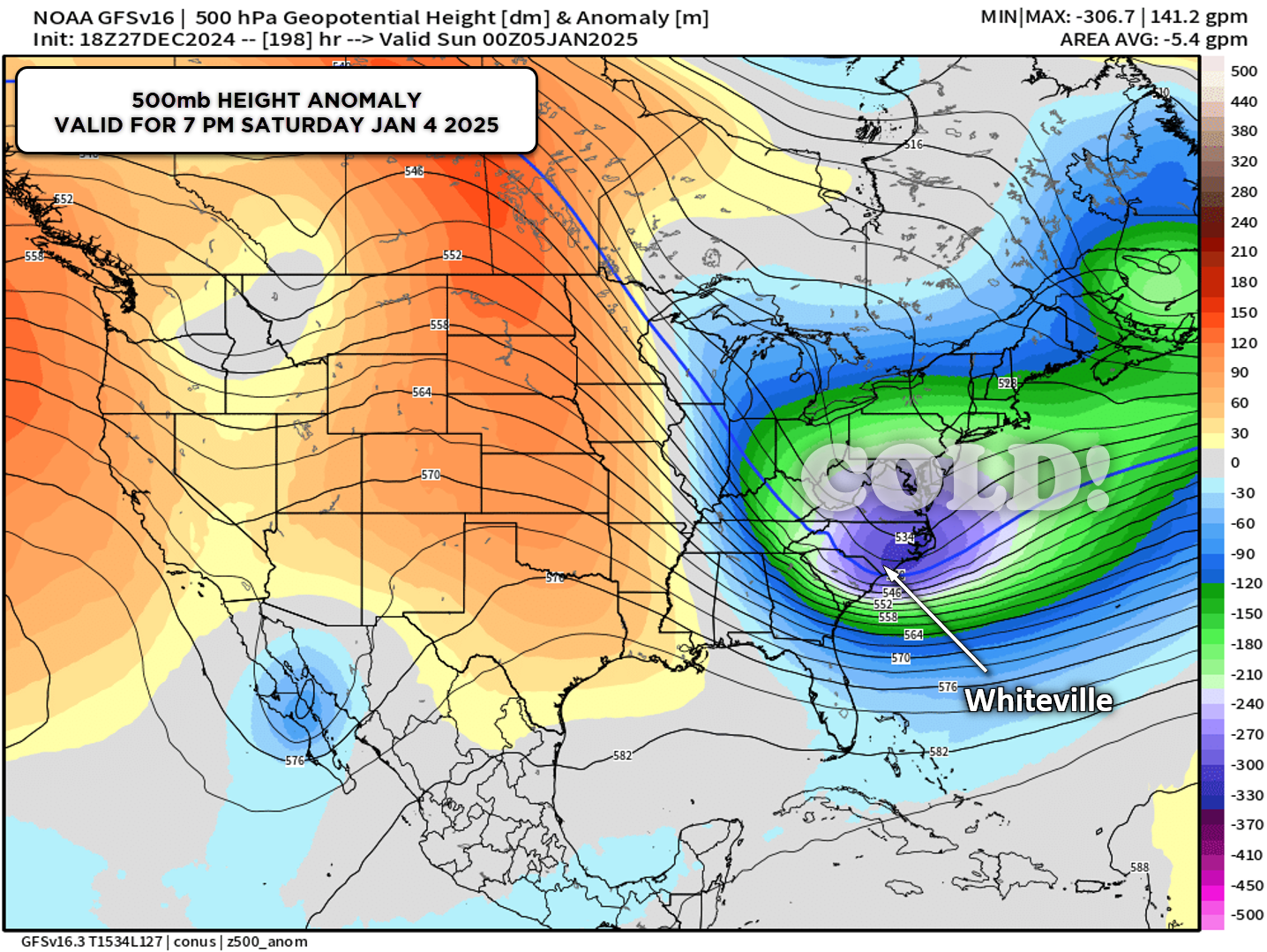
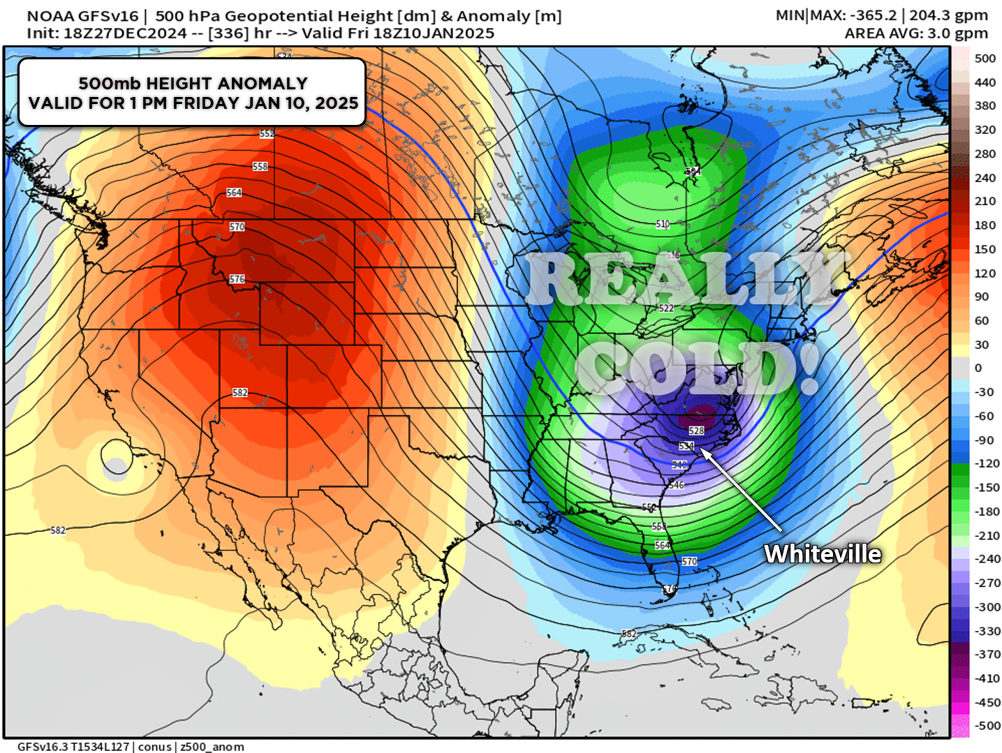
LONG TERM: DEEP cold air is expected to be firmly in place going into the first weekend of the New Year, and then REALLY in place by the end of the first full week of January (the 9th-10th). If we could just get something to spin up on the southern branch of the jet stream…. like some of the Euro modeling suggests…..
Ok that’ll do it for today. Get out and enjoy some of the warmth while we have it. Remember, Sunday is the “action day,” so stay inside, eat pizza, and watch football. Thanks for reading, and take care.